Updated 24th November - Covering 1st - 23rd Dec 2025
Mean temperatures are expected to be above the 1991-2020 long-term normal overall, probably by around 2C in most regions unless we end up with substantial colder weather after mid-December.
It is forecast to be wetter than average in western parts of Britain, particularly western Scotland, the west of Northern Ireland and probably also west Wales, but eastern counties will tend to have near or below average precipitation totals, with north-east Scotland likely to be considerably drier than average.
Sunshine is forecast to be above normal in north-east Scotland but it will probably be below normal in most other regions, especially the west and south.
This week will be mild and changeable, dominated by south-westerly winds, with a strong and persistent Icelandic low. Early in the week, there will be bands of rain crossing the country at frequent intervals, interspersed with brighter showery weather. Later in the week, high pressure will tend to become more prominent to the east and south-east later in the week, bringing some quieter weather into the south and east at times and introducing more of a northwest-southeast split in the weather, with frequent rain bands especially for western Scotland and the west of Northern Ireland, but not much rain getting into south-eastern Britain. Sheltered coastal areas of eastern Scotland and north-east England are also likely to see relatively limited rainfall amounts during the week. It will be windy at times with potential for gales, especially in north-western Britain, and potentially also in the south early in the week, when depressions will take a more southerly track.
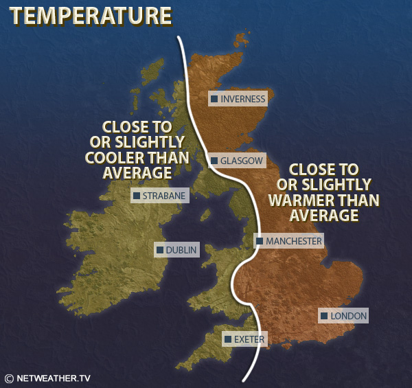
Mean temperatures are thus forecast to be above the 1991-2020 long-term average in all regions, probably by 2 to 3C in the east of England, potentially by nearer 1C in north-west Scotland and the west of Northern Ireland.
It will be wetter than average in most western areas, particularly western Scotland and the west of Northern Ireland, but probably drier than average along the coasts of eastern Scotland and north-east England and probably also in East Anglia.
Sunshine totals are likely to be generally below average in the west and near or above average in the east, with north-eastern Britain most likely to have above average sunshine.
There are signs that we may see more frequent blocking highs to the east and north-east as we head towards mid-December, so winds are expected to become predominantly south to south-westerly, especially late in the week. This will tend to set up a west-east split, with western Britain generally mild and wet, with potential for bands of rain to become slow-moving as they stall against the highs to the east, while eastern Britain will tend to be drier with temperatures often closer to the long-term normal, although rain is likely to sometimes penetrate to eastern areas as well, turning lighter as it moves further east. At present it does not look likely that the highs to the east will be far north enough to draw much in the way of cold air across from the east, and so it now looks unlikely that there will be any snowy spells before mid-December.
Mean temperatures are again forecast to be above normal, but with a shift in the magnitude of the anomalies: the south and east of England are likely to be closest to normal, probably around 1C above normal, while in Northern Ireland and northern and western Scotland, temperatures may end up 2 to 3C above the long-term normal. It will tend to be wetter than normal in the west and drier than normal in the east, and most likely to be considerably drier than normal in north-east Scotland. Sunshine is likely to be generally below normal except in north-east Scotland.
Uncertainty increases in the weather patterns during this period, due to a mix of the upcoming sudden stratospheric warming event, which could disrupt the weather patterns and make high pressure blocking at high latitudes more likely, and the Madden-Julian Oscillation possibly heading into phases 6 to 8. Thus, there is some potential for the blocking highs to the east to become more extensive to the north and north-east, which would bring potential for cold air masses to come across from the east. However, there remains quite a strong signal for low pressure to be strong out in the North Atlantic which could hold those cold air masses away to the east and leave Britain in a continuation of the relatively mild southerlies. In general I suggest that winds are likely to be predominantly southerly during this period, with a slight chance of some cold easterlies developing but northerlies look less likely than average. Overall, the most likely outcome is for near to slightly above-average temperatures, so less mild than the preceding two weeks, with a tendency for wetter weather to extend across the south, probably turning drier than average for much of Scotland, particularly the north. Sunshine is likely to remain on the low side for most but probably above normal in northern Scotland.
Monthly weather forecast
The month ahead forecast is written by Ian Simpson and is updated every Monday.