


Issued 2024-05-17 07:54:27
Valid: 17/05/2024 0800 - 18/05/2024 0600
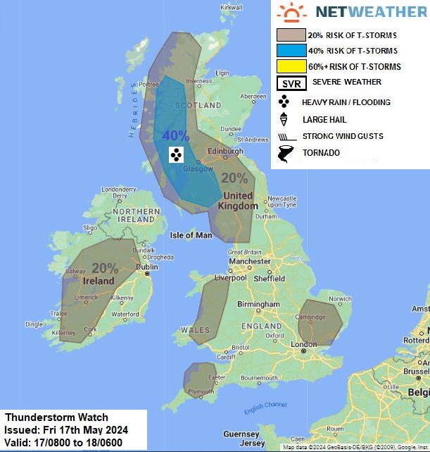
Upper trough will lie across mainland Europe to the south and southeast of Britain, with upper and collocated surface lows over the Bay of Biscay and Germany. East to west warm/moist air advection will continue across much of Britain above low pressure further south over the continent. Pool of cooler air in the mid-levels looks to move west towards Scotland during the day, this will steepen lapse rates above warm/moist airmass heated in sunny spells to yield 500-1000 j/kg CAPE across southern and western areas of Scotland – where breeze convergence also looks to pool moisture. The breeze convergence and orographic lift of mountains looks to support the development of heavy showers and thunderstorms this afternoon across S and W Scotland along with Cumbria. These will be slow-moving – so will pose a risk of localised flash-flooding.
Elsewhere, scattered showers, locally heavy, will develop from the warmth of the day, but capped atmosphere will limit cloud growth and lapse rates look weaker than further north, so thunderstorm risk looks generally below 20%, apart from over E Anglia and also across W Wales, N Devon & N Cornwall along with N and W of the Rep of Ireland, where 20% has been delineated for a small risk of a storm triggered by sea breeze convergence.
Issued by: Nick Finnis
Issued by the Netweather forecast team whenever there is a risk of storms or severe convective weather, these discussion based and in depth forecasts will highlight the areas at risk and give an in depth description of the risk and the factors surrounding it.


.jpg?w=175)