Issued 2024-05-21 07:41:17
Valid: 21/05/2024 0800 - 22/05/2024 0600
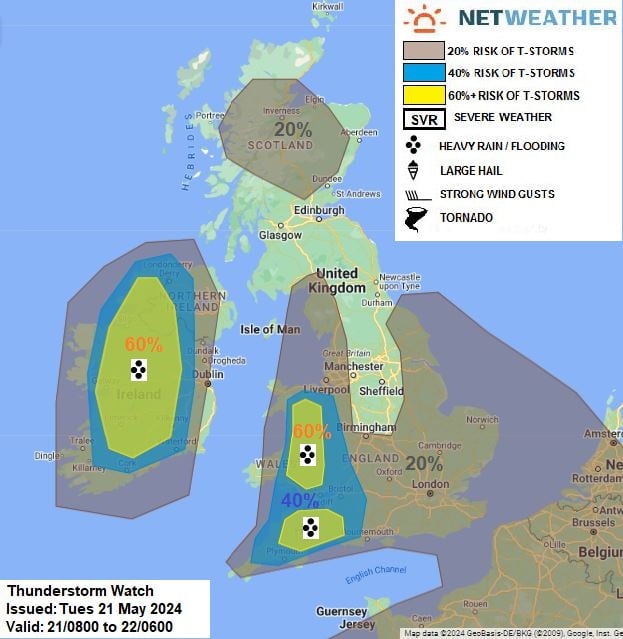
Upper low over N France will continue to drift north on Tuesday to be over S England at midnight, surface low over Germany will drift NW slightly deepening as it reaches Netherlands/North Sea early Wednesday. An occluded front moving NW out of the near continent will bring a band of showery rain across SE England and E Anglia through the morning, this may have sufficiently deep convection to bring isolated lightning as it moves NW. Otherwise – slack pressure pattern will encourage breeze convergence zones to develop inland across western areas of England, Wales, Rep. of Ireland and N. Ireland - which combined with surface heating, will support the development of heavy showers and scattered thunderstorms to develop and these areas will be the main focus for thunderstorms today. Elsewhere, heavy showers are expected to develop across S England, E Anglia & N Scotland, where sunny spells / surface heating develops, which may also produce isolated lightning. Convective cells will be slow-moving, so there is a risk of localised flash-flooding, any storms may also be accompanied by hail. Also, light flow aloft and surface convergence will be the ideal conditions for funnel clouds to form with stronger updrafts.
Issued by: Nick Finnis
Issued by the Netweather forecast team whenever there is a risk of storms or severe convective weather, these discussion based and in depth forecasts will highlight the areas at risk and give an in depth description of the risk and the factors surrounding it.