Issued 2024-05-01 08:45:04
Valid: 01/05/2024 0600 - 02/05/2024 0600
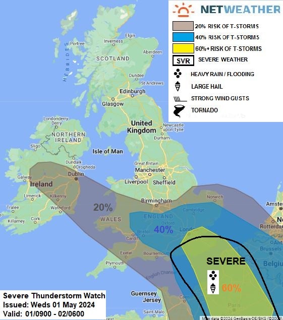
NW-SE elongated upper low sits across the far west of Europe on Wednesday – tending to extend towards the western Mediterreanean, with a surface low over the western Alps drifting north towards Benelux. A plume of higher wet-bulb potential temperatures (theta-w values of 14-16C) will continue to advect NW from central Europe and in across Britain over the next 24 hrs to the north of a warm front moving west across Britain.
Increased lift along the warm front as it reaches SW England and Wales, as increased forcing aloft arrives from France, will bring an area of locally heavy rainfall NW here this evening, perhaps with some isolated thunder & lightning. Further east, substantial destabilisation of the higher theta-w plume spreading WNW over Benelux and N France looks to occur during the afternoon and evening across northern France, as increased forcing aloft from falling heights from the southwest and falling surface pressure from low moving north occurs. High resolution models indicate this forcing engaging the plume and undercut of drier air from the NE at the surface generating an arcing area of thunderstorms across N France during the evening, which could produce large hail (3-5cm diameter) and flash-flooding – before the storms then move N and NW towards SE England / E Anglia overnight. The thunderstorms will tend to be elevated above a stable drier surface flow from the NE, but tapping into MUCAPE of 1500 j/kg MUCAPE, as forecast by ECMWF & AROME. There is some uncertainty over the extent of thunderstorms when they arrive across SE England – however, given large CAPE values forecast – storms may produce isolated large hail (2-4cm diameter), intense rainfall leading to flash-flooding, frequent cloud-to-ground lightning and strong wind gusts. A severe area has been issued for the far SE of England.
A line of storms are forecast to continue NW and N across southern Britain in the early hours, perhaps reaching SE Wales and S Midlands before weakening. Some isolated lightning also possible further west across Ireland and S Wales along northern side of rainfall along warm front.
Issued by: Nick Finnis
Issued by the Netweather forecast team whenever there is a risk of storms or severe convective weather, these discussion based and in depth forecasts will highlight the areas at risk and give an in depth description of the risk and the factors surrounding it.