


There's more rain on the way as we lead-up to Christmas, but there should at least be a break from it on Christmas Day.
We still have a fair number of flood warnings in place mostly in the South, and unfortunately, there's more rain to come overnight. After that conditions will slowly improve, as it becomes primarily fine and dry by Christmas Day, but it's unlikely to last, with more rain spreading from the West later on Boxing Day. So no white Christmas this year I'm afraid, except for some hills over the North and North East of Scotland.
For most, it's bright today with sunny intervals, although with a few showers, The bulk of them are currently over central Scotland where some are heavy, with the central belt and southern Scotland and parts of Northern Ireland likely to see a lot of cloud at times and showers today. Elsewhere they'll be scattered allowing sunny intervals, with the showers falling as snow over the mountains of North Scotland. Not everywhere will see them however, with eastern England, best placed to stay dry.
A South West or westerly wind will feel chilly particularly over northern Scotland where after an early slight frost, some sheltered glens may struggle to reach 2 or 3C. Elsewhere temperatures generally will be close to normal for the time of year and on the mild side in the South, reaching 5 to 7C in the North and 8 to 10C further South. Towards the South West 11C is possible, but here, cloud will increase towards dusk threatening rain.
After a fine start to the evening East of the Pennines, all but Scotland and the far North of England, turn cloudy overnight with some rain. There'll be heavier bursts, with southern England, parts of Wales and the Midlands seeing a change to more broken skies and just a few showers moving in later. Most of Scotland and Northern Ireland see fewer showers these mostly in the North where they'll fall as snow on hills.
A South West wind becomes fresh and blustery across southern coastal counties, but with somewhat lighter breezes elsewhere. Where you see cloud and rain temperatures won't fall below 4 to 8C Where skies remain clear over Scotland however you'll see a frost, with temperatures dropping as low as -4 or -5C in some sheltered glens.
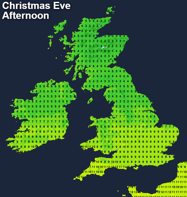
Christmas Eve remains unsettled with showery rain over England and Wales mostly during the morning. Scotland and Northern Ireland see scattered showers that'll fall as snow on northern hills. By the afternoon most places see an improvement, with sunny intervals eventually coming through. Winds will be mostly moderate or fresh Westerly making it feel chilly, with top temperatures only 3 to 6C in the North and 7 to 10C in the South. In some sheltered Highland glens, however, the thermometer may not get much above freezing.
There'll be further showers into the evening, with any snow for Santa mostly confined to the hills of Highland and Grampian. As a transient ridge moves in though, the showers become increasingly limited to coastal areas and the North and East by Christmas Day morning. A cold West to North West wind will also decrease a little, and as skies break, there'll be a touch of frost in some sheltered rural areas by dawn as temperatures mostly fall to between 1 and 6C. Seasons greetings to all!


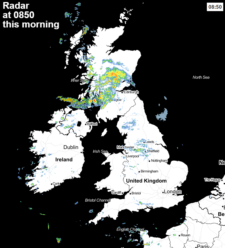 Check the latest radar here.


