After a very wet 48 hours, there is more rain in the forecast as we close in on Christmas. High pressure should give us a respite by Christmas day though.
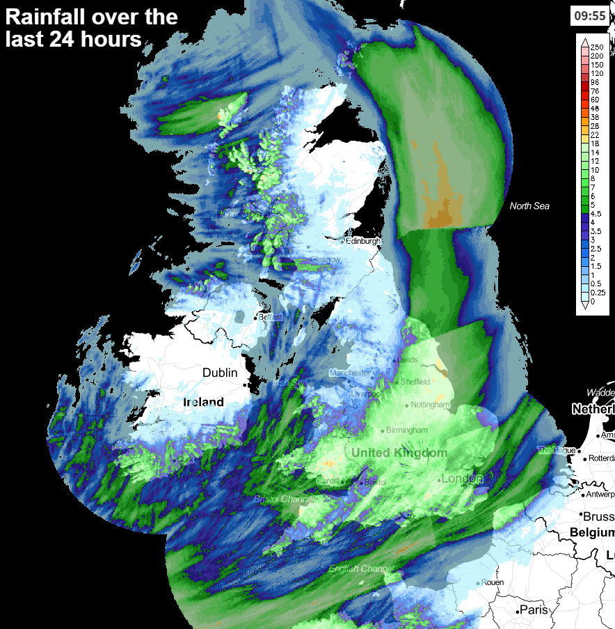
Well, it hasn't been the ideal start to the Christmas getaway, with heavy rain, flooding and plenty of disruption on the roads and railways. Yesterday saw another drenching, with a wide portion of England and Wales seeing 10-20mm of rain, all falling onto the already sodden ground.
Today isn't looking quite as wet, for most but there will be some sharp showers around through the day. Then a spell of persistent rain will move up from the southwest across southern areas later on and overnight. It's not all doom and gloom though, as there will be some bright or sunny spells away from the showers, so it should be a more pleasant day for travel or last-minute Christmas shopping. Temperatures will vary from 4-7c across the northern half of the country, 6-9c further south.
The low bringing the next batch of wet weather will arrive into the southwest this afternoon, before zipping through into other parts of southern England this evening. It'll take a while to clear away overnight, finally easing away from the southeast tomorrow (Sunday) morning.
For the remainder of the country, Sunday will be quite similar to today, with some decent sunny spells but also a good scattering of potentially heavy showers - these most frequent in the west. It'll be a breezy day in most parts, and blustery in the south with gales near to the coast. Temperatures will be on a par with today.
Into Monday, the sunshine and showers theme continues with most of those showers in the west and particularly northwest of the country. Similar to Sunday though, there'll be another system on its way up from the southwest later to bring a spell of wind and rain. This time the rain is likely to be more widespread, pushing up into much of England and Wales during the evening and overnight. In the meantime much of Scotland will stay drier, with a scattering of showers, mostly affecting western parts.
By the morning of Christmas Eve (Tuesday), much of the rain will have cleared to leave a scattering of showers. Then with high pressure starting to ridge north, that quieter theme will continue. That'll mean plenty of sunny spells to end the day, and with clearer skies overnight, patchy frost and fog are likely in time for Christmas morning. For most, Christmas day will stay fine, dry and chilly, but there is a spoiler low which may make a move in from the southwest.
There's some uncertainty over this one, it may be that rain and strengthening winds move up from the southwest later in the day, but equally some models keep the low further away for longer. Something to keep an eye on as we move through the latter part of Christmas day and into Boxing day.