


At long last, we are getting rid of the awful, damp, gloomy weather so typical of November, as things turn drier and much brighter from the North by tomorrow. It'll be becoming noticeably colder too.
At long last, we are getting rid of the awful, damp, gloomy weather so typical of November, as things turn drier and much brighter from the North by tomorrow. It'll be becoming noticeably colder however, but with today still relatively mild, particularly over the southern half of England and Wales.
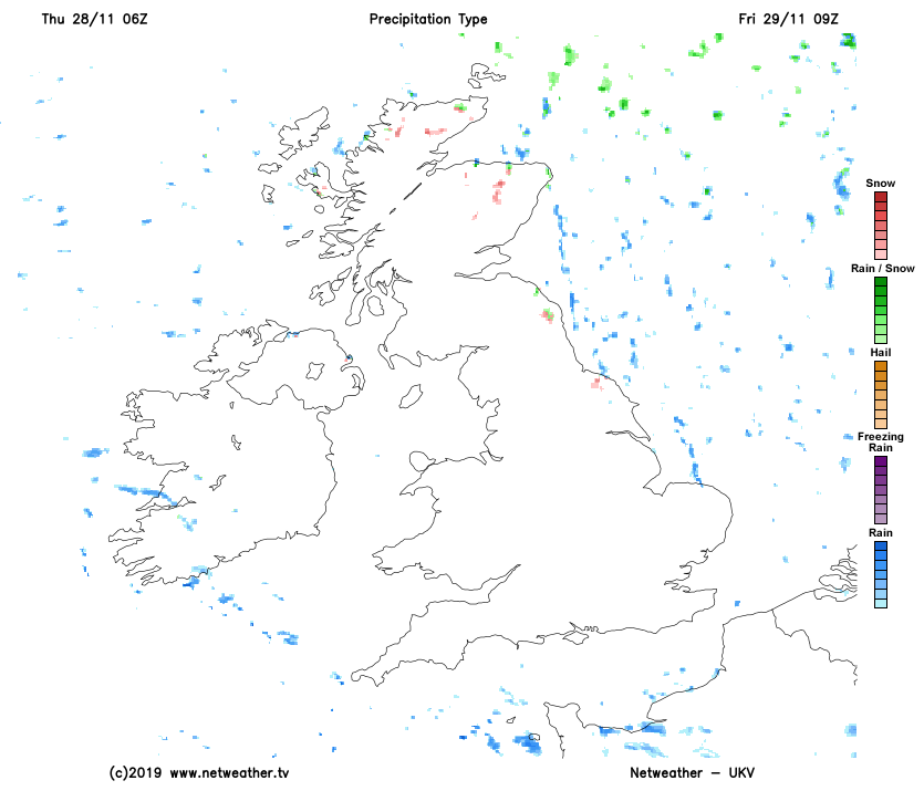
Although parts of the South see sunny intervals for a while, it's another grey and in places misty start over the bulk of England and Wales. We also have some rain across northern England, parts of Wales, the Midlands, East Anglia and the South East. Much of it is light, but there are heavier bursts across the South East, with the rain moving South through the day and becoming showery. After a damp start in the south, Scotland and Northern Ireland turn brighter with some sunshine, particularly in the West. Across the North and East of Scotland however, scattered showers turn increasingly wintry on hills, as colder air spreads from the North.
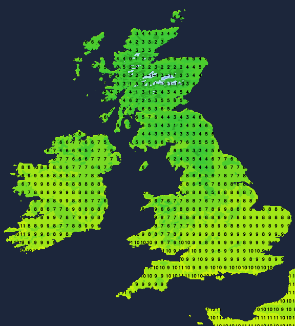
A Westerly wind that'll be fresh in the English Channel and along the South coast at first will decrease. Elsewhere there will be a North West or northerly wind which will spread to most parts through the day. This'll be fresh and gusty over the North and East of Scotland and of Arctic origin making it feel quite raw. As a result, temperatures here remain around 4 to 7C, with 8 to 10C more likely further South.
Central and southern parts see further mostly light showers into the evening, that should have cleared from all but the far South West and the South coast by morning. This'll allow skies to break, with clear spells developing especially over Northern Ireland and across more western and central areas leading to a frost. Towards the East coast cloud amounts will vary, with the North and East of Scotland continuing to see a scattering of wintry showers giving hill snow.
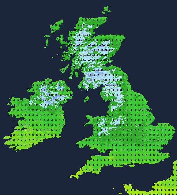
A raw North wind will be fresh and blustery towards North Sea coasts, but somewhat lighter in the West. Over much of Scotland, Northern Ireland, the West and in some central areas temperatures will fall to between 0 and -3C, with some sheltered Highland glens perhaps falling as low as -5 or -6C. In the South, towards the East coast and where you keep cloud, you'll escape a frost, with 3 to 5C more likely here.
Friday will be finer once remaining cloud has cleared from the far South West. The welcome change will bring lots of sunshine, although still with a scattering of showers across the North of Scotland and towards some North Sea coasts. These will be wintry on hills, with further snow falling on Scottish mountains.
A raw North wind still fresh and gusty along some North Sea coasts for a while will be lighter generally, with temperatures getting no higher than 4 to 6C in the North and 7 or 8C in the South.
The North and East of Scotland continue to see a few wintry showers after dark, but for most, there'll be clearing skies. Winds fall light allowing a widespread and in places sharp frost to develop and also a few freezing fog patches. Temperatures could fall as low as -10C in the coldest spots, but -2 to -5C will be a more general minimum.


