With chilly winds and bands of showers whirling around a low pressure it is an unsettled Tuesday but eyes are on more rain from Thursday onwards and the flooding risk.
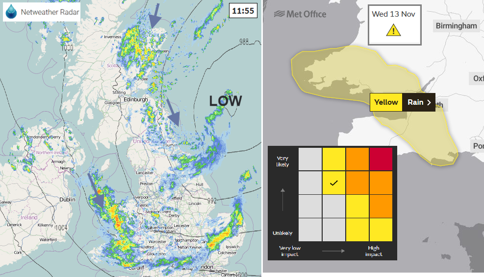
We have heavy rain and strong winds whirling around a low pressure which has moved out over the North Sea this morning. It will be a blustery unsettled day, with heavy rain warnings this morning and numerous flood alerts and warnings too.
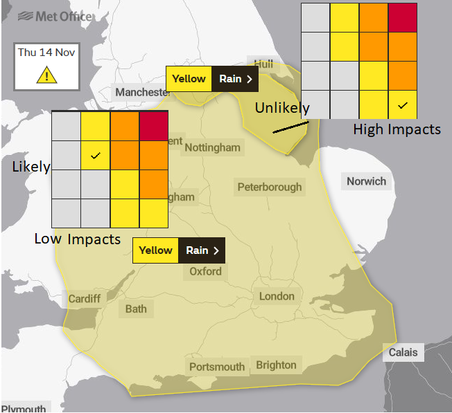
On Monday a yellow warning for heavy rain on Thursday was issued as the next low pressure dives south and pulls in rain for England with particular concerns for the flood hit areas of the East Midlands, Lincolnshire and South Yorkshire.
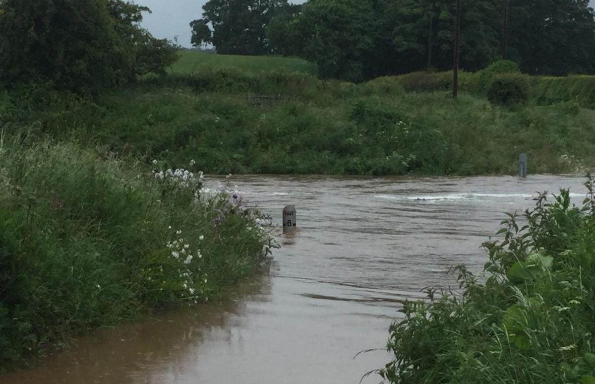
River levels remain high, still the five severe flood warnings on the River Don, flood plains are full and the ground sodden. This has been a very wet autumn. Any more rain is causing concerns.
It is cold this morning in the brisk wind and after clear skies overnight allowed temperatures to fall away. Over the next few mornings, it will be cold with a frost for sheltered spots and decidedly chilly for Friday night. The west to SW winds veer to a cold NW direction and it will feel cold for the coasts of Wales and also eastern England this afternoon as the wind drives in.
This morning there has been a yellow warning for Rain for eastern counties of Northern Ireland, that finished at 10am. Also, a wind warning for north Wales this morning with severe gales and very rough seas mentioned in the Inshore Waters forecast. There is also an ongoing yellow warning for rain for parts of Midlands and Yorkshire and there has been an area of rain, from an occluded front pushed down from the Irish Sea over Wales and the warned area this morning. Another occluded front is bringing heavy rain to NE Britain. There will be areas of heavy showers throughout the day with bright spells in between. Southern England has started the day with sunshine and there is a gap around the Solway Firth, but these rain bands are shifting southwards as the blustery conditions continue.
The winds ease down tonight as many of the showers ease off inland. A feed for Northern Ireland, Wales as the showers for NE Britain fade. It does become a cold, clear and calm night, a lull in between weather systems. With temperatures for inland Scotland down to -6 and -3C for the far north of England, it will be a frosty start for Wednesday with ice in places.
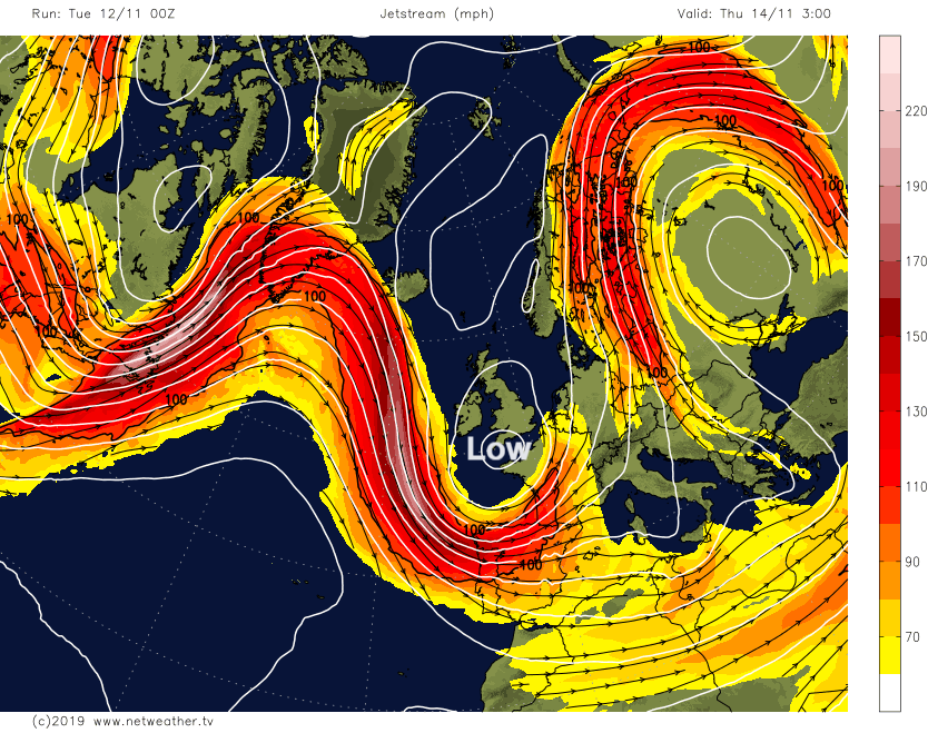
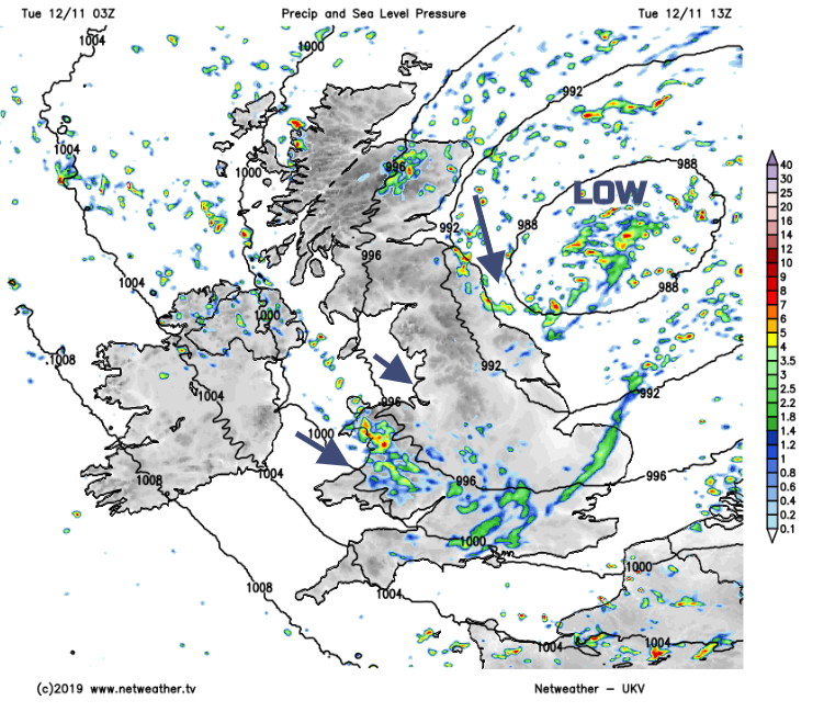
The buckling Jetstream guides a low pressure from Greenland down past Ireland and SW England to the Bay of Biscay. When there is a more zonal flow the jet powers west to east across the Atlantic, whisks deep low pressures across the UK, sometimes as storms and we get wind damage but not the linger rain which has already caused some much flooding. There haven’t been any named storms yet this season. As low pressures get caught in the great meanders, their rain bands get stuck and dump large amounts of rain which has happened several times this autumn.
Wednesday looks fine and sunny for many but there will be showers for SW Britain with a spell of heavier rain late afternoon/evening for SW England, southern Wales and then southern England by the evening. There is now a Yellow warning for Rain from the Met Office. Windy around the low centre, particularly for Cornwall later in the day.
As the low pressure rotates across mainland Europe the worry, and hence the early yellow warning for rain, is that the frontal bands will bring persistent rain to England. More rain for soggy ground and high rivers. The bands could reach into SE Scotland and Wales, both wet as well but the risk of ongoing rainfall continues into Friday even the weekend. There will be brisk winds from the east or NE during Thursday and Friday, adding to the miserable feel to things and hill snow. The inner section of warning has been highlighted because these areas are so flood-sensitive. There is some uncertainty about there the rain bands will settle but the rainfall totals show more rain from the east over several days.