


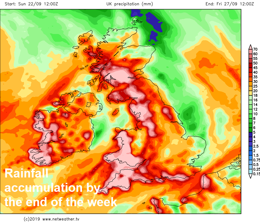
On cue with the start of astronomical autumn, the weather will turn increasingly unsettled over the next few days, with wind and rain at times, or sunshine and showers, cooler too.
It’s the autumn equinox today, the start of astronomical autumn, when the sun is directly in line with the Earth's equator, resulting in day and night being equal in length. But from today, the nights will grow longer and days shorter until the winter solstice on around 21st December. After the fine and warm weather under high pressure last week, the weather is also on a downward turn into a more autumnal feel, with low pressure taking charge bringing unsettled and cooler conditions for the rest of this week, with spells of wind and rain or showers, but there will also be some dry and sunny spells at times too.
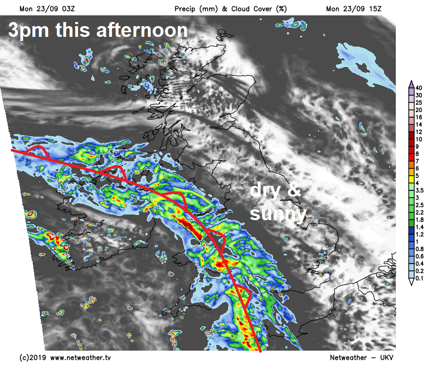
For many though, Monday should remain dry for much of the day. A few well-scattered showers will affect northern England, Wales, Northern Ireland and the north of Scotland this morning, before gradually clearing away. But otherwise it will be a dry and bright or sunny morning for many. Clouding over through the morning across SW England and south Wales, with outbreaks of rain already affecting southern Ireland spreading in later in the morning.
.png)
Cloudy skies and outbreaks of rain will continue to spread north and east across SW England, Wales, Republic of Ireland and Northern Ireland through the afternoon – accompanied by a strengthening southerly wind. But for the rest of Britain it will continue to be mostly dry with sunny spells through the afternoon, though a few scattered showers are possible across northern Scotland. Temperatures this afternoon reaching 17-18C at best under the cloudier skies and rain spreading in across the west, but in the sunnier skies elsewhere we are looking at temperatures reaching 18-21C.
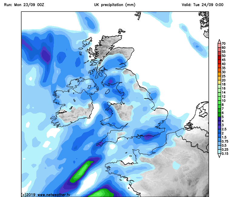
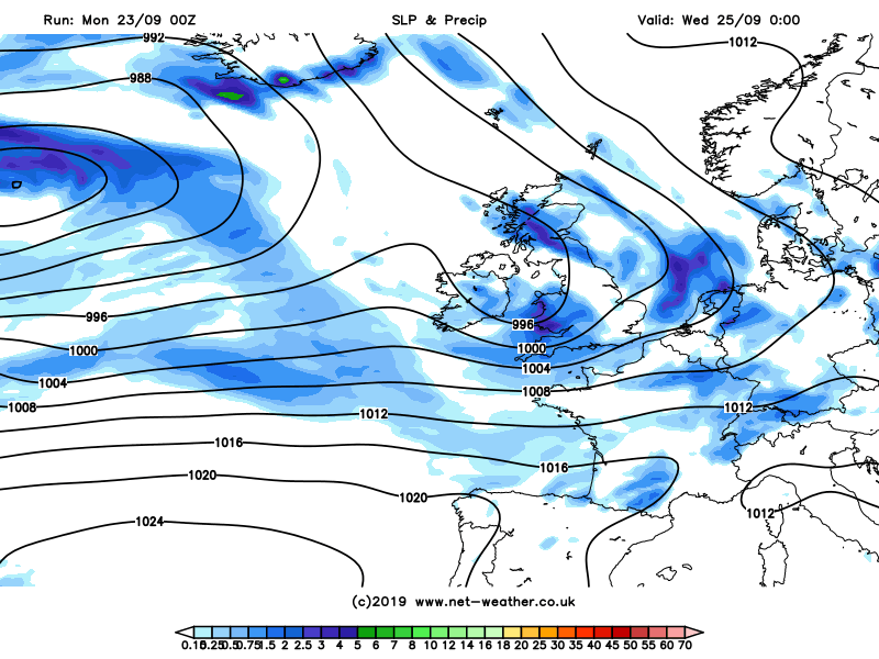
Turning wet and increasingly windy across many parts overnight, as sets of fronts spread areas of rain northeast across many areas, rain turning heavy across Wales, central and southern parts of England, with thunder and lightning locally. Northern Scotland perhaps staying dry with clear spells. Despite the wet weather setting in, it will be a mild night, temperatures falling no lower than 12-15C.
A wet and windy start across much of Britain away from northern Scotland, that may start dry. Rain will be locally heavy with thunder across central, southern and eastern areas of England for the morning commute, with a risk of standing water and spray bringing some tricky driving conditions. A Met Office yellow warning for rain across southern parts has been in place since yesterday morning.
Heavy and thundery rain will gradually clear northeast from central and eastern England later in the morning followed by brighter conditions but with blustery showers already moving in across Wales and SW England. Heavy and thundery rain spreading northeast across northern England and Scotland through late morning and into the afternoon, but further south brighter with showers, perhaps heavy with thunder, affecting mostly SW England and Wales, but a few showers spreading across southern England too. A cool and windy day, temperatures reaching 17-19C in any brightness, but under any rain only 15-16C at best. Winds gusting to 30mph inland across southern Britain, perhaps 40-50 mph around southern and western coasts.
Heavy thundery showers, perhaps merging into longer spells of rain, spreading east from Wales and SW England across southern England Tuesday night, clearing SE England Wednesday morning. Otherwise Wednesday will be a day of sunshine and showers for many, though some places may escape the showers and stay dry. Temperatures ranging from 16-18C in the north, 18-20C in the south. Less windy than Tuesday.
An active frontal system associated with a deep low moving in to the northwest of Britain will bring a band of heavy rain and strong winds across the west Wednesday night, before sweeping east across all parts Thursday morning, followed by brighter skies with showers in the west, but rain perhaps not clearing Scotland until the evening.
Low pressure centred close to the northwest and tightly packed isobars will ensure a cool and windy Friday with sunshine and showers.


