
There's some rain across the northern half of the UK today but warmer and drier further south. Next week, with high pressure taking hold, there'll be plenty of fine, dry and increasingly warm weather on offer.
We have a cold front moving slowly South across the country, with gales over the far North of Scotland, bringing a few blustery showers to Orkney and Shetland. These'll fade through the day as winds decrease, with central and northern Scotland seeing some sunshine. Along the front, there's patchy rain affecting parts of northern England, southern Scotland and Northern Ireland where some of the rain is quite heavy.
 Check the latest rain radar here.
To the South of the front across much of Wales, the South Midlands, Home Counties and southern England it'll be another dry day with sunny spells. Although unlike yesterday, there'll be more in the way of cloud at times in a mostly light Westerly breeze. The best of the sunshine will be in the South where it'll become warm or very warm again, as temperatures reach 22 to 25C. To the North of the front, however, it'll be cooler, with temperatures getting no higher than 13 or 14C over northern Scotland and 16 to 18C more generally.
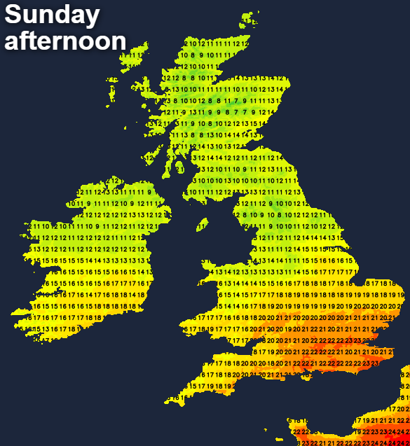
Orkney and Shetland may see further rain or showers moving in overnight as a South West wind freshens again, with the rain clearing from Northern Ireland into the evening. This'll leave the province together with most of Scotland with clear spells after dark. Light winds will allow a few mist or fog patches to form in rural areas. It may also turn cold enough for a touch of grass frost in some vulnerable glens as temperatures fall to 4 to 8C and 2 or 3C in the coldest spots. Southern England may also see clear spells, but across parts of the Midlands, North Wales and northern England there'll be some rain, that'll prevent temperatures from falling below 8 to 11C.
The far North and North East of Scotland sees a Westerly wind bringing a few further showers into the new working week. There'll also be more cloud over the Midlands, East Anglia and southern England particularly at first, but any remaining showers on the weak front will fade. As a result, it'll become mostly dry, with the bulk of the country increasingly fine with sunny spells on Monday. After a chilly start in the North, it'll feel pleasantly warm in the sunshine in a light West or North-West breeze.
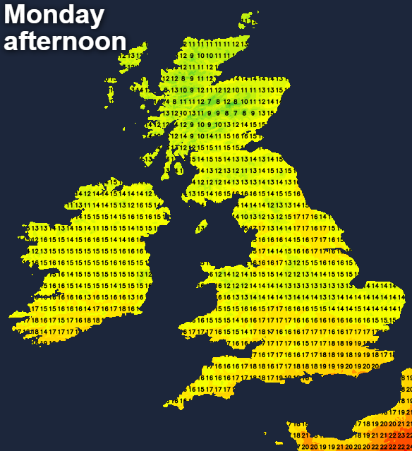
Even so, top temperatures of 14 to 16C in the North and 18 to 21C in the South will be down on recent values.
Apart from the North and North East of Scotland where a further scattering of showers is likely, it'll continue mostly fine and dry after dark. There'll be clear spells, and with light winds, it'll soon turn chilly. A few mist or fog patches will form again towards morning, with a touch of grass frost also possible in vulnerable rural valleys of the North, with lowest temperatures 5 to 8C and 1 to 3C in the coldest spots.
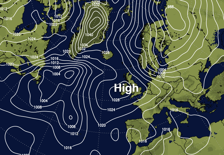
With an anticyclone dominating much of the remainder of the week, it's going to be mainly dry and quite pleasant in most parts. There'll be sunny spells, but light winds will result in some chilly nights with mist and patchy fog. As temperatures rise later in the week, though, the risk of grass frost will diminish. Enjoy!


