


There'll be wind and rain at times this week, thanks in part to the visits of ex-Dorian and ex-Gabrielle. But then a fine weekend beckons as the jet stream buckles and moves north.
September marks the peak of the hurricane season with not one, but two ex-tropical storms affecting the British Isles this week. Firstly will come the remains of ex-hurricane Dorian that'll pass to the North mid-week, with ex-Gabrielle following on bringing humid conditions to southern and central parts for a while on Thursday. But don't worry, as they'll be nothing more than vigorous Atlantic systems bringing a couple of bouts of wet and windy weather.
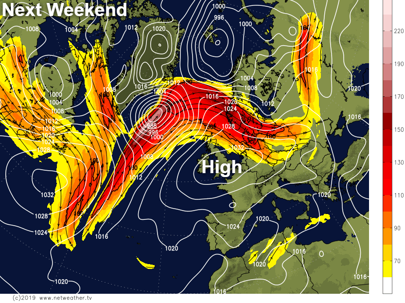
Sometimes these storms can be beneficial to us, as they interfere with the Jet Stream causing it to buckle. This'll encourage pressure to rise sharply after the passage of ex-Gabrielle, with the prospects for next weekend looking fine particularly for central and southern areas.
We currently have several slow-moving bands of rain through the spine of the country, in a mostly dull start to the new working week. Some of the rain is heavy, particularly over South Wales, the South West and the Channel Islands, where you could well hear some thunder through the day. It's not wet everywhere though, with East Anglia, the far East of England and parts of central southern England still dry. The Northern Isles and the far East could well remain dry, but be prepared for a shower mostly this morning. The rain will turn lighter and more patchy through the day, allowing a few sunny intervals to come through later.
Across Northern Ireland it's a much brighter picture with western parts of the province, in particular, seeing sunny spells. That should eventually spread to Down and Antrim where there have been a few showers to start the day. A North West wind will be gusty over exposed parts of Northern Ireland, Dyfed and in the far South West but elsewhere, winds will be light. It'll be chilly though mainly in the rain, with temperatures getting no higher than a rather cool 13 to 17C.
As the slow-moving fronts weaken and break up, it should eventually become mostly dry overnight. Into the evening though the South West could some sharp bursts of rain, with the North East of Scotland also probably 'holding on' to a few showers. Where skies break mostly in the far East, over Northern Ireland and West Scotland, it'll turn quite cold with temperatures falling as low as 4 or 5C in the coldest spots. Light winds could also allow a few mist or fog patches to form in rural areas, but more cloud elsewhere should prevent temperatures from falling below 7 to 11C.
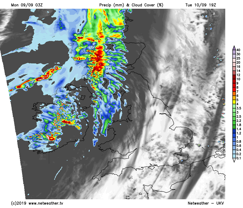
After a dry, bright start over much of Northern Ireland on Tuesday, cloud and freshening southerly wind will bring rain from the West. This'll be heavy in places spreading to the West of Scotland later, as the remnants of ex-hurricane Dorian begin to move in.
Elsewhere there'll be a mixture of patchy cloud and some sunshine, with any remaining pockets of mostly light rain soon 'petering-out'.Through the afternoon though, western areas will see cloud increasing again perhaps some bringing patchy rain towards evening. Light winds at first will become South West or South, lifting afternoon temperatures between about 16 and 20C.
After a dry start in central and eastern areas, most places see some rain moving in during the evening or overnight. This'll be light and patchy in the South but heavier in the North and West, followed by blustery showers across Northern Ireland and the North of Scotland later. A South to South West wind will become fresh or strong, with gales becoming severe in exposed parts of the North and West where gusts of over 60mph are possible.
It'll be a milder night though, with temperatures generally not falling below 9 to 12C.


