


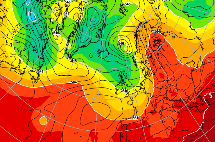
A new day, a new season meteorologically speaking and a change of air mass to a polar maritime type. Hello Autumn.
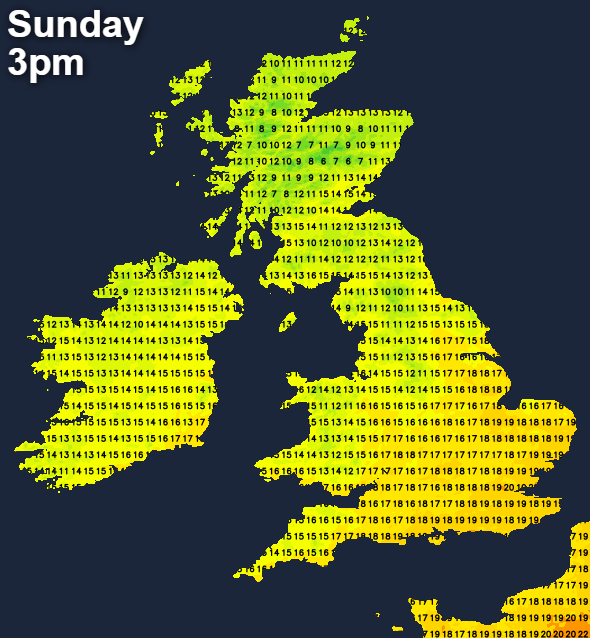
A new day, a new season meteorologically speaking and a change of air mass to a polar maritime type, all add up to a very different feel to the weather this Sunday. It's a much chillier start than of late, but a fine one for most with some sunshine, although cloud will build through the morning to bring a scattering of showers.
We already have a few showers mostly over Scotland where they'll become more widespread and heavy in places, giving local hail and thunder by the afternoon. North and North East England will also see some heavy showers, with a scattering in the West and over Northern Ireland where the showers may become more widespread later. Elsewhere they should be few and far between, with much of the Midlands, South and South-West probably staying dry where you'll see the best of the sunny spells.
It'll feel noticeably cooler in a moderate locally fresh North West or Westerly wind that'll be blustery in the heavier showers. As a result, the new month will begin chilly, especially across Scotland where temperatures will get no higher 12 to 15C. Elsewhere 16 to 19C is more likely, with sheltered parts of the South and South-East reaching 20 or 21C, but even this will be down on recent values.
A West or South-West wind continues to bring a further scattering of showers into the evening. These'll be most frequent in the West and over the North of Scotland, with many central and eastern areas seeing clearing skies after dark. This'll allow it to turn quite chilly, with temperatures falling to 6 to 9C quite widely. In some sheltered eastern areas, around the Welsh marshes and over rural parts of South Wales, the thermometer could fall as low as 4 or 5C, cold enough for perhaps a touch of ground frost briefly around dawn in a few prone 'hollows'. Later in the night, increasing cloud across Northern Ireland brings some rain.
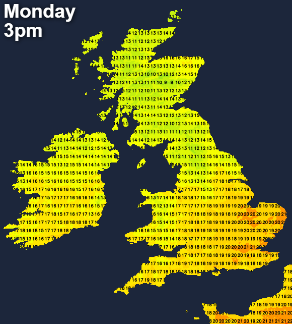
After a bright start in the East, Scotland and Northern Ireland have a wet start to the working week. The rain will be heavy at times in the North and West where a fresh or strong South West wind will give gales in exposed areas for a time. Towards Lothian and The Borders; however, the rain may be more intermittent.
Northern England especially Cumbria and the North and West of Wales also see some rain and leaden skies for a time on Monday, after a bright start towards Northumberland. Western coasts and hills will see some drizzle. Otherwise, remaining parts of England and Wales should be mostly dry and a little brighter, with the best of the sunny intervals in the South East at first, where the South West wind will be lighter. After a chilly start, temperatures will reach 13 to 17C in the North, 18 to 20C more generally and 21 locally 22C in the South.
The rain over Northern Scotland should clear to just a few showers after dark before more rain probably moves in from the South West by morning. Across Northern Ireland and northern England, there may be further rain at times, with more broken skies and mainly dry weather further South. A South West wind will give a milder night generally, when temperatures shouldn't fall below 8 to 12C
The rest of the week looks like remaining in much the same mood. The south will see the best of the weather, with the majority of any showers or outbreaks of rain further north. Temperatures will briefly recover, before it turns cooler again from mid-week, with autumn certainly upon us now.


