Temperatures climbing into the low-thirties under often sunny skies this weekend. Amazing for a bank holiday, and potentially record-breaking for the late-August holiday too.
It's a bank holiday weekend for most this weekend, the grand summer finale with events up and down the country, and the weather is playing ball. It's not too often you can say that on a long weekend. Sunshine and warm, if not hot temperatures will be the theme for a good part of the country - with just the far northwest seeing some rain from time to time.
Yesterday saw temperatures peak at 28.8c in Hull, that's likely to be bettered by a few degrees over the coming days. There are some temperature records to keep an eye on over the weekend. Firstly, the hottest temperature ever recorded during the late August bank holiday is 31.5c (2001 at Heathrow). The highest recorded late August bank holiday Monday is currently 28.2c (Holbeach in 2017). And regardless of whether it's a bank holiday or not, daily records across the weekend could also be in danger:
Today's record (Saturday 24th) may be safe though, with forecast maxes likely to be around the 29c mark in eastern and central England.
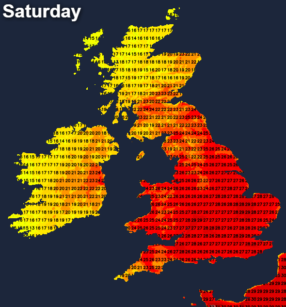
Much of the rest of the country will see highs into the mid-twenties with the exception of western and Northern Ireland, along with the northern half of Scotland. Here, there'll be a bit more cloud around and a few outbreaks of showery rain running in at times. For the majority though, it's a day of long sunny periods, albeit with a bit more cloud running into the west later in the day.
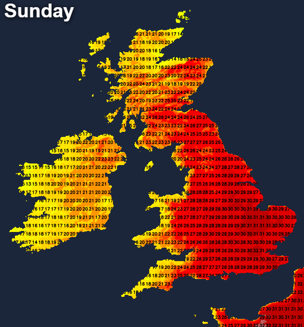
Some low cloud will form overnight, but it stays dry for the vast majority with any rain in the north and west dying out. Then into Sunday, much of the cloud will quickly burn off to leave just about everyone to enjoy sunny spells and another hot day. Western coastal counties will be fresher and cooler by this point but head further east, and the heat will quickly rise. Temperatures are liable to peak into the high-twenties or low-thirties quite widely.
More low cloud and murk will form again overnight, with even some mist or fog patches in western regions by dawn. It shouldn't take long for the sun to break through again on Bank Holiday Monday. Although the northwest of Scotland, along with the far west and north of Ireland, could see some rain arrive later in the day.
Temperatures will again climb up into the mid-high twenties or low-thirties for many. The western fringes of England and Wales will stay cooler, along with the western half of Scotland and much of Ireland (North and South).
There is the threat of some showery rain, perhaps even thunderstorms running up into the south later on and overnight, but at the moment this looks like a very low risk and unlikely to happen.
The weed pollen season is in full swing currently, and there'll be moderate levels of that throughout the weekend. So if you're a hayfever sufferer, that's something to bear in mind.
Don't forget that the sun is still very strong at this time of year with high UV levels. Cover up and wear suncream if you're out and about to avoid getting burnt. You can check your pollen and UV levels in our local forecasts here.