While there'll be a fair amount of dry, warm weather this weekend in the East and South, the overall picture remains unsettled.
While there'll be a fair amount of dry, warm weather this weekend in the East and South, the overall picture remains unsettled. Atlantic systems will bring more rain or showers by Sunday particularly to the North and West. So for those areas still affected by flooding, or mopping-up after the recent deluges, this won't be good news, particularly for the Whaley Bridge area. Then, there will be further showers or outbreaks of rain some heavy and thundery, expected throughout next week.
Although not entirely settled today, we have a relatively uniform pressure gradient across most parts for the start of the weekend, so winds generally will be light. Most parts start dry, and there'll be sunny spells through the morning once mist, patchy fog and low cloud have cleared this mostly in the East. Some cloud will build to produce a few possibly sharp showers by the afternoon, these mainly over Northern Ireland, West Wales, North West England and the West of Scotland.
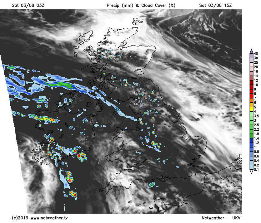
Elsewhere any showers will be isolated. So it should stay dry for the Test Match at Edgbaston, while across the South West it'll turn dull, misty and wet in places later.
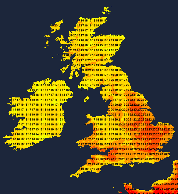
After the placid start, a South-East or southerly breeze will develop in the West, becoming moderate locally fresh over exposed parts of Northern Ireland later. It'll end up another warm day though in most areas. Temperatures will reach 18 to 24C fairly generally and 25 or 26C across the South East and perhaps parts of East Anglia, where you see the best of the sunshine.
Apart from the odd rogue shower, many central and eastern areas together with the North and East of Scotland have a mostly dry evening and night. There'll be clear intervals, and with only gentle breezes, mist and a few fog patches could form once more chiefly in rural areas. Elsewhere showers are more likely as Atlantic systems move in from the South West. Some of the showers will become heavy and lengthy over Northern Ireland later in the night, although not everywhere will catch one, in a mostly light or moderate a South or South Easterly wind. It'll be a very mild somewhat humid night, with temperatures falling no lower than 11 to 13C in the North and 14 to 16C further South.
East Anglia and the South East continue to have the best of the weather on Sunday. But after a fine start especially towards North Sea coasts, it'll tend to cloud over with the threat of catching a shower becoming more acute through the afternoon. Elsewhere although bright at times with sunny intervals, there'll be a scattering of showers. These'll be most frequent over Northern Ireland after a brief lull across the province, in western Britain and more particularly over parts of northern England and Scotland. Here, some will be heavy with a few thunderstorms by the afternoon giving local torrential downpours.
A southerly wind will be gusty near the heavier showers, but despite this most parts become warm again. Over parts of East Anglia, and the South-East a very warm, humid 26 or 27C is possible, but 18 to 24C will be a more general maximum.
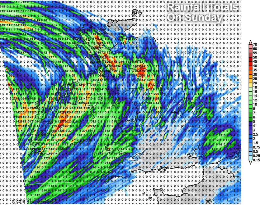
By Sunday evening most parts will probably have at least seen a shower, although parts of the South and South-East may stay dry overnight. For most, though there'll be a further scattering of showers some heavy and thundery in the North at first, between drier spells that'll give broken skies. It'll be yet another very mild somewhat humid night though in a southerly wind that'll be gusty in exposed areas, with temperatures generally falling no lower than 11 to 16C.