


Warm and humid with some thundery showers in the east today, elsewhere drier and fresher. Heavy rain for northern and eastern areas this weekend, cooler for all.
Thursday brought the UK’s hottest July day on record, with the temperature reaching 38.1C at Cambridge. This was also the second hottest temperature ever recorded in the UK, the all-time record for the UK still stands at 38.5C at Faversham, Kent back on the 10th August 2003. So we weren’t far off breaching the all-time record yesterday, mid-level cloud and showers spreading up from the south across SE England may have thwarted temperatures getting even higher than they did. But it was exceptionally hot nonetheless.
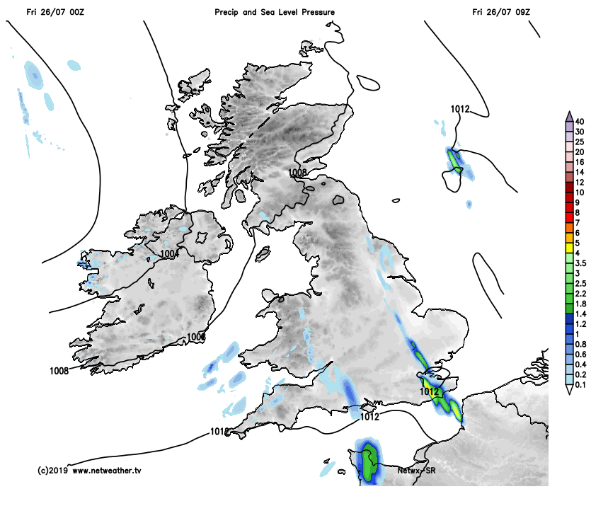
However, the next few days will offer relief from yesterday’s exceptional heat, with everywhere cooler today. A cold front has slowly edged east overnight, so it will be cooler across western areas, the cold front won’t clear eastern England until tomorrow, so it will be another very warm and humid day here, but because there will be a fair bit of cloud and thundery showers, it will be nowhere as hot as yesterday.
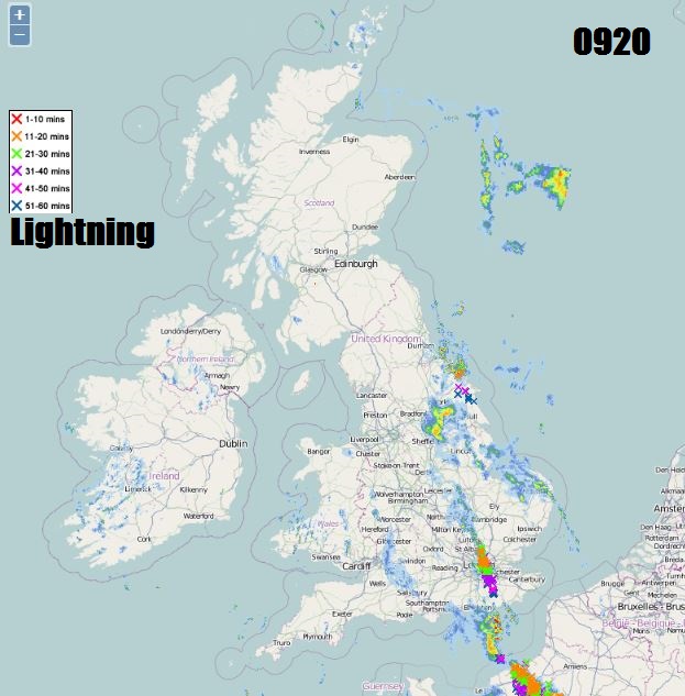
Despite the heat yesterday, no overnight records have been broken, but it’s been a very warm start to the day. Temperatures still in the low twenties at dawn in the east ahead of the cold front, and at 8am already 25C in East Yorkshire. There are some lines of heavy downpours and thunderstorms rumbling their way north across SE England, East Anglia, Lincolnshire and East Yorkshire this morning. Further north and west, it’s a generally drier picture with variable cloud and some sunshine, particularly further north. Cloudier across the south and southwest, with a few showers.
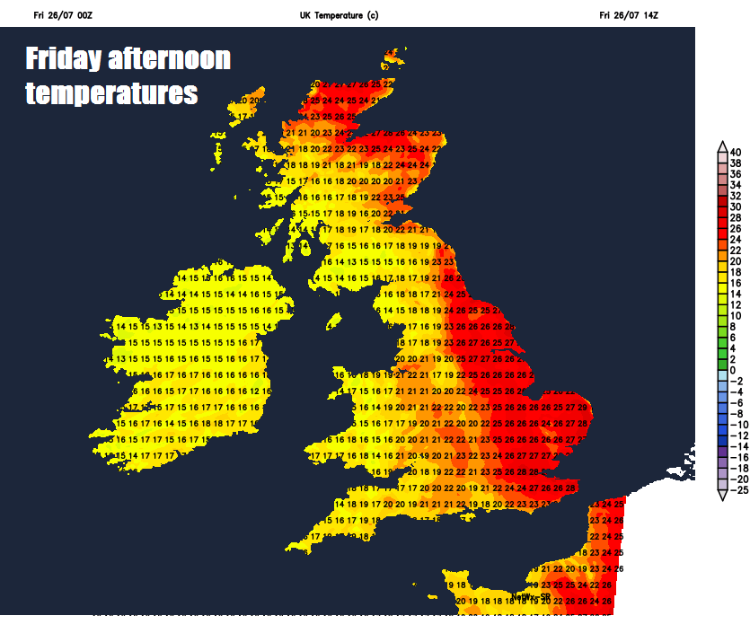
Eastern England and eastern Scotland will stay on the warm side of a slow-moving cold front today, so although it will be very warm and humid here today, it will be rather cloudy at times with thundery downpours working north in places, but not everywhere will see them. If the sun does come out, it will feel hot and sticky, with temperatures reaching 26-30C. Elsewhere, after a cloudy morning with some patchy rain across southern and central areas of England along with Wales, it should become drier and brighter here to join NW England, Scotland and N. Ireland to a mostly fine and dry afternoon, with sunny spells. Temperatures reaching 21-24C and feeling fresher then recent days.
The slow-moving cold front lying across eastern England and eastern Scotland will pep-up overnight, so some heavy and locally thundery pulses of rain developing along it across eastern Scotland, along with northern and eastern England. Elsewhere, it will be drier but rather cloudy away from SW England, Wales and N. Ireland – where there will be some clear spells. Comfortable overnight temperatures in the west, but in the east it will be a warm night with temperatures no lower than 15-17C.
Saturday will feature a slow-moving frontal boundary lying across northern and eastern Britain – which will bring a cloudy and wet morning across northern and eastern Scotland along with eastern England, with pulses of heavy rain. The front will gradually pivot, so rain tending to spread further west across Scotland and northern England while easing across SE England after perhaps a wet start here. Part sof NE England and eastern Scotland could see a few inches of rain by the end of the day. Elsewhere, a few showers for central areas, mostly dry and bright or sunny across SW England, Wales and N. Ireland. Temperatures ranging from 17-20C in the north, 20-23C in the south.
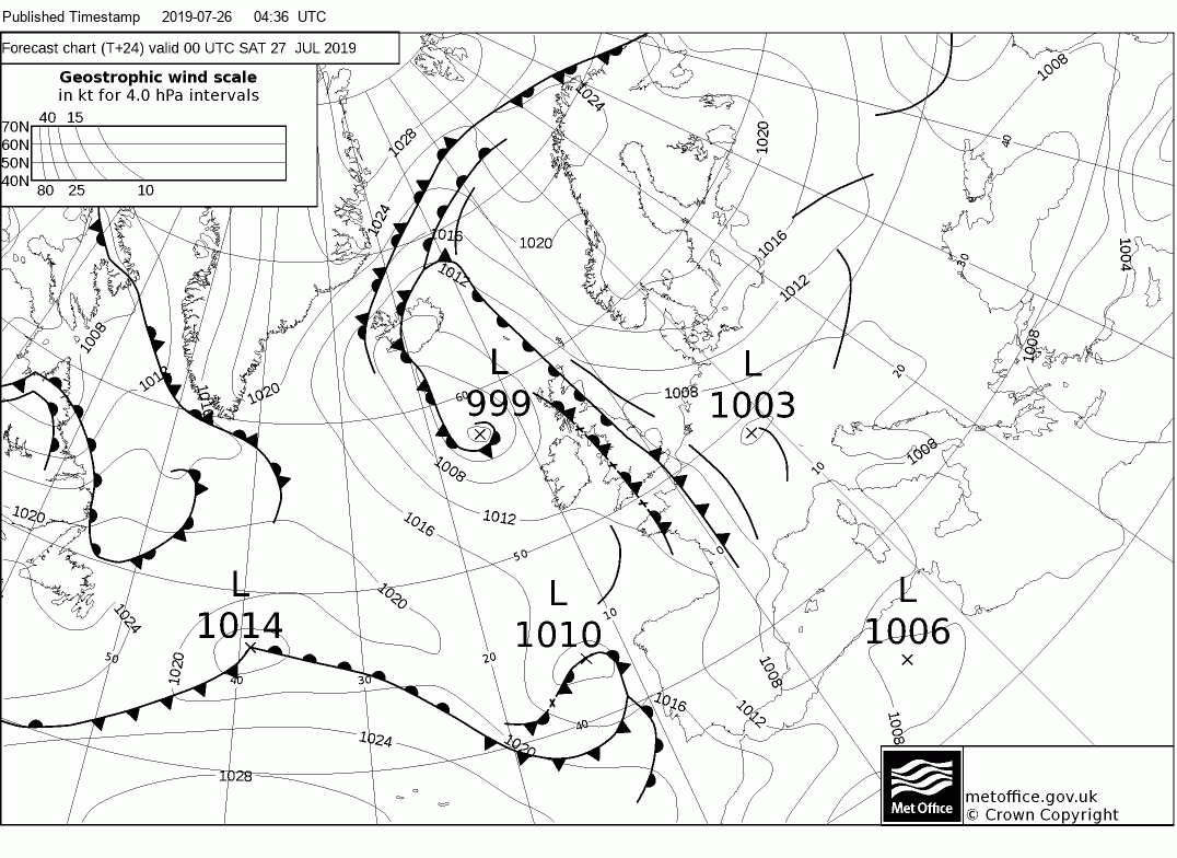
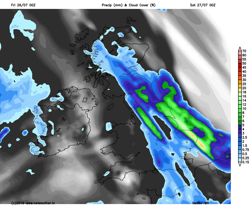
On Sunday, the slow-moving frontal boundary will continue to pivot a little further west across the north, so band of slow-moving rain likely to lie from western Scotland, across southern Scotland, northern England and onto Norfolk through much of the day, could bring some flooding problems across northern England with 2 days of persistent rain. Either side of this rain band it will drier with some sunny spells. Temperatures reaching 18-20C in the north, 21-25C in the south.
Monday is looking cloudy with outbreaks of rain across Scotland and N. Ireland, dry and bright morning for England and Wales, before outbreaks of rain arriving in the southwest spread across southern areas. Rain clearing the southeast Tuesday morning, then thundery showers developing across the south, northern areas drier. More showers across the south on Wednesday, drier and brighter in the north.


