


Heat & humidity building across England & Wales this week, we could see 35C across SE England mid-week, some thunderstorms breaking out in places though

England and Wales are set for a very warm or hot and sunny week ahead, as we start to draw in a southerly flow from France – where temperatures may reach 41C as far north as Paris by mid-week, while London could reach 35C. Scotland and Northern Ireland will become warm or very warm too for a time. There will be a risk of thunderstorms at times though, particularly Tuesday night across parts of England and Wales, then generally across the west at times for the rest of the week.
For now, it’s been a rather wet night across the north, with heavy and persistent rain still affecting the north and west of Scotland, so there will be a lot of surface water on the roads for the morning commute here. Further south across England and Wales, it’s a drier but rather cloudy picture, cloud thick enough to bring patchy light rain or drizzle over western hills. Though there is some breaks in places to the lee of high ground across central and eastern areas, allowing some sunshine.
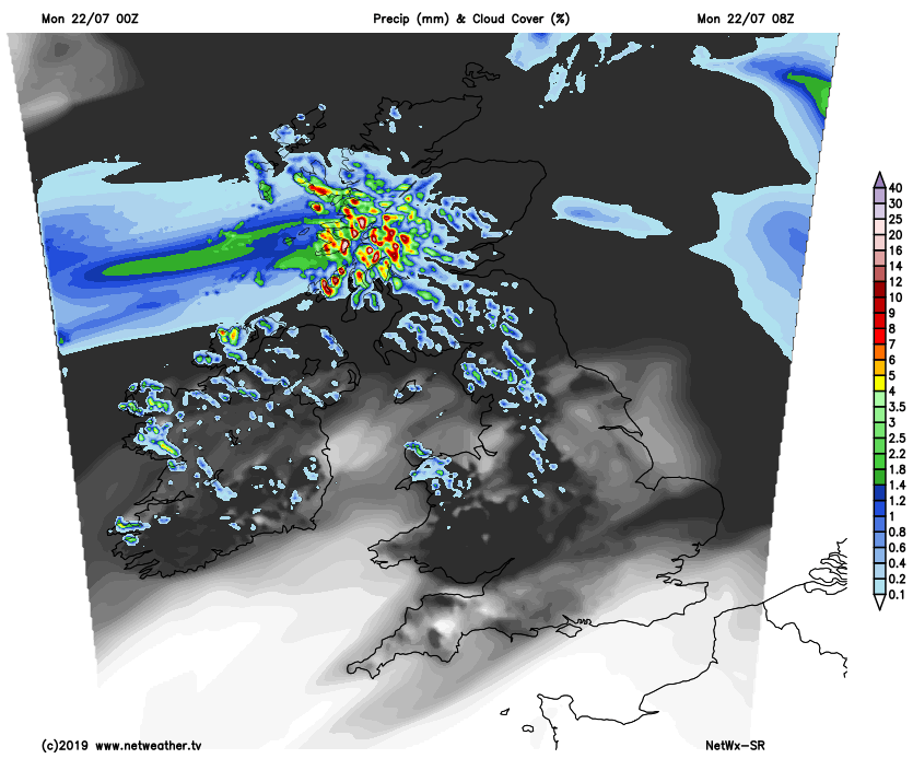
Rain will continue across northern and western Scotland for much of the day, heavy and persistent over western slopes. Elsewhere across Scotland and NW England along with western coasts of Wales and far SW of England it will likely stay rather cloudy for much of the day – cloud thick enough for some patchy drizzle. Northern Ireland and eastern Scotland likely seeing some warm bright or sunny spells towards the east. Elsewhere though, across central, southern and eastern England, early cloud should thin and break to allow increasing amounts of sunshine to develop through the morning and into the afternoon.
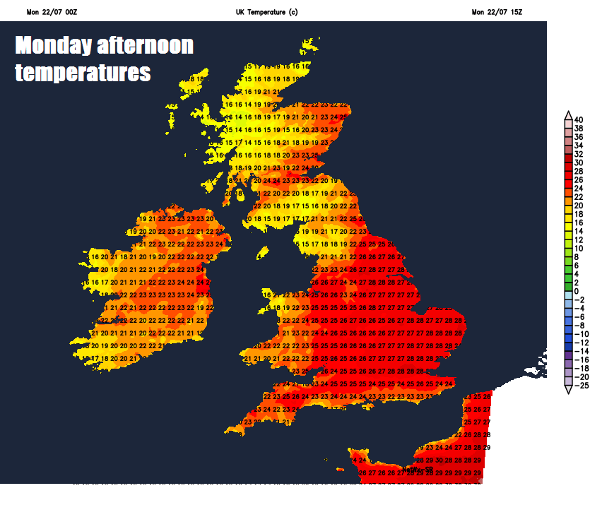
Becoming hot across central, southern and eastern England – temperatures here reaching 26-29C. Western areas of England along with Wales reaching 23-25C. Scotland and N. Ireland reaching 20-24C.
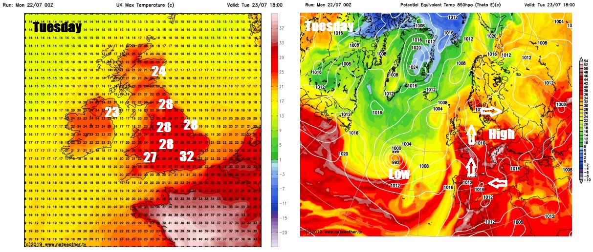
By Tuesday, high pressure builds over the near continent, while low pressure stalls to the west over the Atlantic – which will draw hot and humid flow from the southeast off a very hot continental Europe. With much of the UK under the influence of high pressure, clear skies and the air becoming increasingly humid will mean temperatures rocketing into to low thirties Celsius across central and southeastern England, mid-high twenties elsewhere. We could see 32-33C reached in London and the southeast.
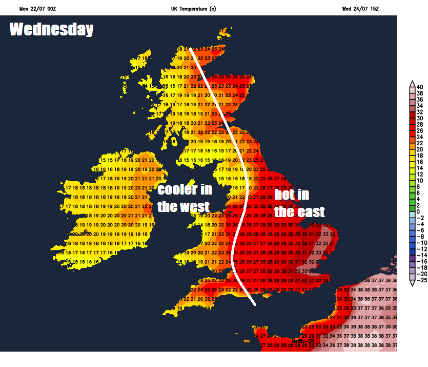
 Wednesday
Temperatures very slow to fall Tuesday night across the south, so an uncomfortable night for many here, also thunderstorms look to break out across parts of England and Wales overnight, these storms clearing away northeast across northern England and Scotland during the morning, followed by another dry, hot and sunny day across central, southern and eastern England, perhaps even hotter than Tuesday, with 35C possible in London. Perhaps fresher conditions spreading in across the north and west, with some thundery showers in the far west, but most will stay dry and sunny, temperatures still reaching the low-to-mid twenties.
More hot sunshine for central, southern and eastern England on Thursday, as we continue to draw in a hot and humid southeasterly flow off the near continent here, temperatures in the low thirties again. Perhaps warm and sunny for eastern Scotland too, but towards western areas of Scotland, N. Ireland, Wales and western parts of England – we could see more in the way of cloud along with some thundery outbreaks of rain spreading north. These may spread further east than currently suggested.
Likely a change to less hot conditions across the east on Friday, as fresher and cooler conditions spread east off the Atlantic, pushing away the oppressive heat and humidity flooding out of the near continent. There will be a scattering of thundery showers around too, particularly for northern and western areas. Nonetheless, it will still be very warm across eastern England – where will see the sunniest conditions.
Cooler, fresher and more unsettled conditions into the weekend, as low pressure takes over from the Atlantic, though perhaps a northwest to southeast split developing, where the north and west sees more unsettled, windier and cooler conditions, while the south and east see drier, sunnier and warmer weather, perhaps locally very warm in the southeast.


