After plenty of rain and several flood events this week, the worst of the heavy rain is easing. However, there will be more showers from the west over the weekend but 25C showing by the middle of next week.
After one soggy week, the wet weather is beginning to ease. There is still rain about today and hefty showers from the west at the weekend, but the worst of the heavy, persistent frontal rain is passing, and most river levels and waterways are now receding.
There is still plenty of standing water at Wainfleet in Lincolnshire where the RAF was called in to help with the riverbank breach. Conditions on the roads were difficult and with the rain, breeze and temperatures around just 12C, it was a pretty miserable day. SE England fared better with temperatures up to 17C and by next week it will be warmer with mid 20sC in the forecast. A bit more like June.
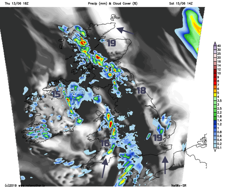
A low-pressure centre has moved away from NE Britain and is away to the NW of Scotland now. It will lurk through the weekend swinging out to the west of Ireland. Rotating around the low pressure we have occluding frontal bands, pockets of showers and early on Saturday another little low running up to Northern Ireland bringing more rain to Wales, SW and NW England and SW Scotland.
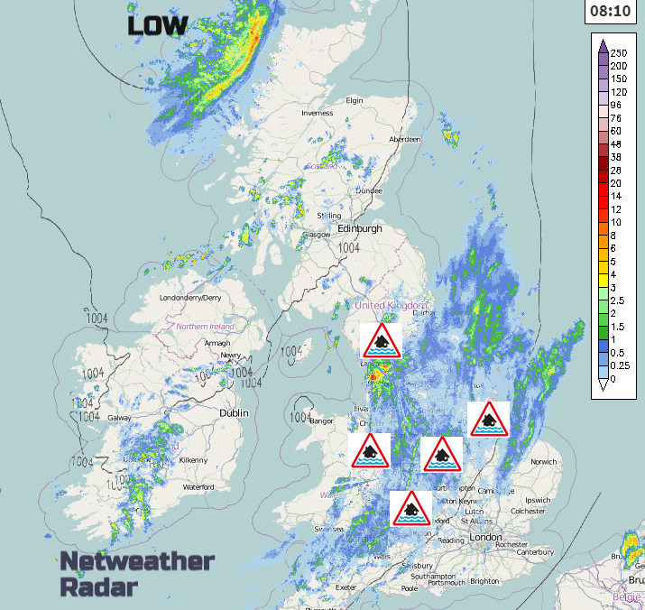
Thursday - Local flooding from rivers is probable today through parts of the north Midlands and Lincolnshire and is possible in the north-east of Wales and the north-east of England. Continuing local river flooding impacts are possible but not expected along parts of the River Severn from Friday to Sunday, causing ongoing operation activity (e.g. flood defences in place). Local surface water flooding is possible but not expected across parts of central, eastern and north-eastern England today due to heavy showers, and on Saturday in the far south-east of England. Environment Agency
5 day forecast should be updated mid morning
Today there is the wet patch across a swathe of Britain SW to NE which will turn more showery through the day, so some hefty downpours with brighter spells. Temperatures vary from 12 to 17C with a light to moderate S to SW breeze. To the SE it is more sheltered with a fair day developing. More of SE Britain should become drier and brighter this afternoon with earlier sunshine for Kent and Essex then more areas as temperatures reach 17 or 18C in a noticeable SW wind. The rain area eases this afternoon for northern England although still dotted with a few showers. For Scotland and Northern Ireland, there will be sunny spells and a scattering of showers. Temperatures in the low to mid-teens. Winds will be light for Northern Ireland but fresh for NE Scotland from the southeast.
It will become cooler overnight with clearing skies away from the wet and blustery weather heading up from the SW.
Saturday will see warm sunny spells but still the risk of blustery showers. Temperatures will be in the mid to high teens so warming up a bit but still unsettled and unreliable.
Sunday sees more showers, more heavy ones, even thunderstorms. Still bright or warm sunny spells in between but fewer of them especially in the west and for Northern Ireland. Eastern areas should be more sheltered but not immune.
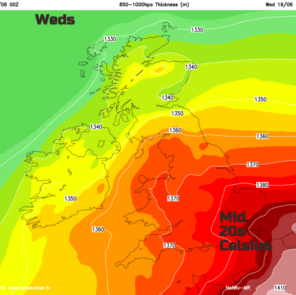
Next week does look warmer, quite noticeable after the recent wet and cool conditions. It’s still looking mixed though, with some fine, dry spells then cluster of heavy, even thundery showers.
Worried about flooding, where to find information and current data
Current river Levels and graphs of past weeks