Weather warnings and flood alerts continue today with more rain forecast. Changes for Friday and the weekend but it still looks unsettled and cool. Warmer next week.
It’s still all about the rain today. Flood warnings and alerts, weather warnings and persistent heavy rain in places. Things change later today but Friday and the weekend remain cool and showery, blustery at times and still unsettled with heavy showers coming in from the west. If you are a bit put out by having to wear a big jumper or even put the heating on in mid-June, next week does look warmer, into the mid-20s.
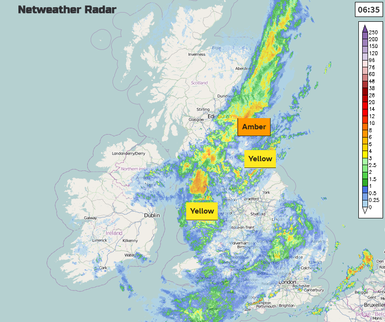
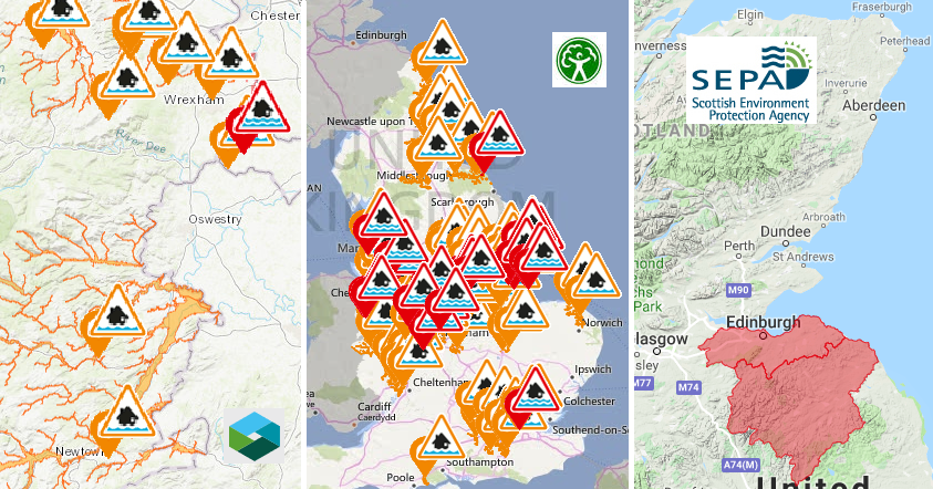
There are two yellow warnings for heavy rain from the UK Met Office, one for north Wales and the other for NE England into SE Scotland. There is an amber warning within that for Lothian and Borders with 80 to 100mm of rain expected over the hills. Flood alerts and warnings continue. To find more information, or if you are worried about flooding there is a new blog bringing together lots of the data and advice.
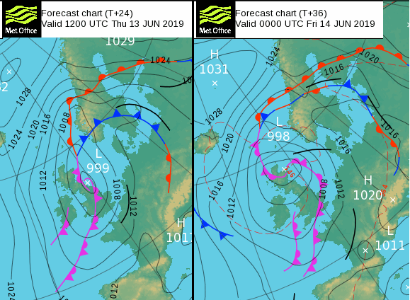
Low pressure just sticks over the UK rotating its weather fronts slowly around, bringing more and more rain. During Friday the low drifts to the NW and lurks there for the weekend so the UK will be in a more SW flow and finally some respite for eastern Britain, but everywhere remains unsettled
Northumberland recorded 72mm of rain in just over a day, 3” into Thursday morning, that rain band is what is causing the issues over SE Scotland now and will pivot here, bringing a wet morning to eastern and NE Scotland. The rain then spreads over northern Scotland this afternoon. The rain over northern Britain begins to ease later this afternoon.
To the south of the low centre, there are other bands of rain moving eastwards. Cumbria, Northumberland and the Pennines continue to see heavy rain this morning and there will be slow-moving bands of rain across Wales, (easing this afternoon) and other parts of England today. The environment agency mentions surface water flooding for SE Britain as the rain turns more showery this afternoon. So not such a wide band of rain, but still some heavier downpours scattered about.
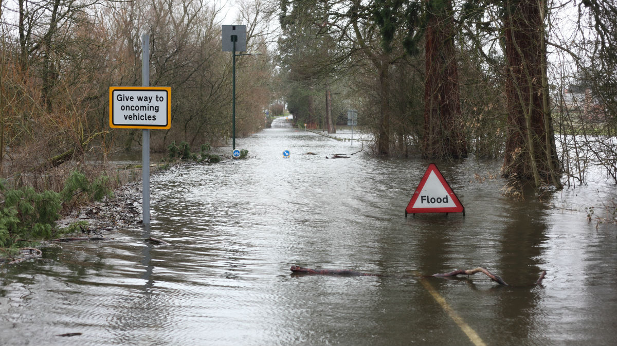
All that water won’t just suddenly dry up so the ground will remain sodden, and flood alerts will continue as rainwater flows down from the hills.
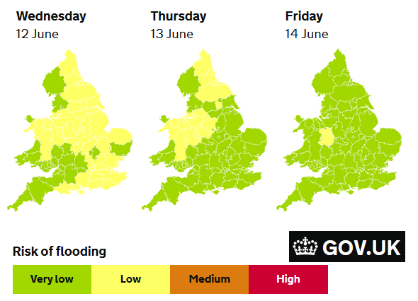
“Ongoing local river flooding is then probable for central England on Friday and possible into the weekend.” Environment Agency
On Wednesday Hampshire did manage a top temperature of nearly 18C but for many today it remains cool with temperatures of 10 to 14C. For SE Britain there is a brisk southerly wind and for northern Britain, north Wales, around the Irish Sea and Northern Ireland a cold north wind, lighter winds in between the two.
Northern Ireland and western Scotland will manage some sunny spells this afternoon and there will be brighter skies for NW Wales, the Isle of Man this evening.
Tonight
As the low position changes, rain will move over western Scotland and another area heads into Wales and SW England. This moves up into the Midlands, maybe reaching Yorkshire for Friday morning and through the afternoon there could be some heavier showers breaking out from the remnants of this, for inland England. Overall for Friday afternoon it looks drier and a bit warmer for SE Britain, into the high teens. Eastern England and the East Midlands should also feel less cool, finally. So clearer skies and nippier night into Saturday morning when a little low pressure runs up from the SW bringing rain to Northern Ireland. Showery outbreaks will also affect Wales and the SW
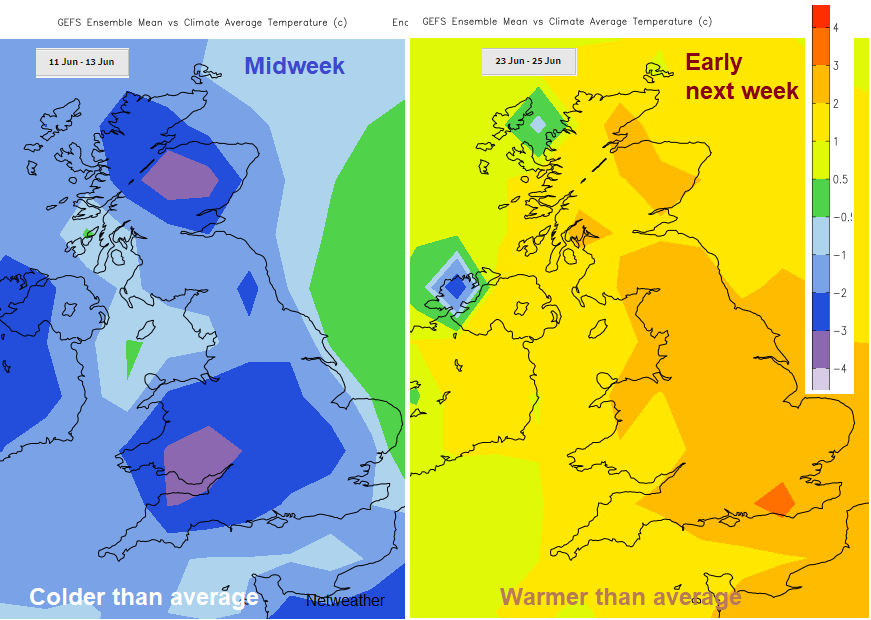
Overall for the weekend, it’s a mixture of hefty showers, even thundery ones with bright spells. The winds will be from the SE, S or SW and temperatures in the brighter areas, mainly in the east into the high teens. Low to mid-20s C by next week as pressure tries to build.
Worried about flooding, where to find resources and information, including warnings