Temperatures will be on the rise this week, with a very warm, if not hot weekend on the way - especially across southern Britain. In the meantime though, there's some wet weather to deal with.
Bang on cue for the start of (meteorological) summer, we're going to see rising temperatures from the south as we end the week and move into the weekend. Maxes into the high twenties look likely -, particularly in southern and southeastern parts. But blink, and you'll miss it, as cooler weather seems set to arrive back in time for the start of next week.
Before we get to that point though, we've some wet weather to deal with. Starting today, we've got showers again; they're chiefly going to affect eastern and southern regions, with a few sharp ones likely to develop. You could even hear the odd rumble of thunder in amongst them.
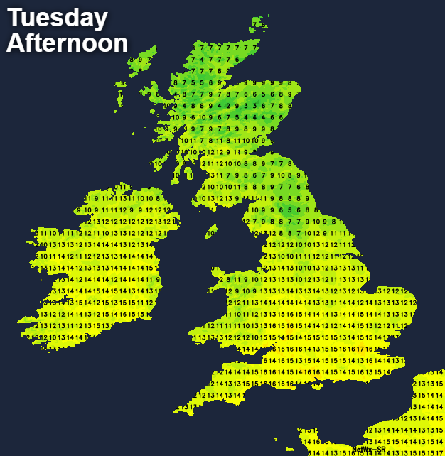
Further west, it's looking drier and brighter with high pressure ridging in. It's not going to be an especially warm day, wherever you are though, with temperatures peaking at 15-17c in southern and central parts. For the rest of England, Wales and south Ireland, 13-15c will be more like it. Then for Northern Ireland and Scotland, 8-13c will be about your lot.
Most of the showers will die back this evening, bringing a dry start to the night for the majority. With often clear skies and a cool airmass overhead, a touch of frost is likely in sheltered parts of Northern Britain - especially Scotland. Cloud and some outbreaks of rain will already have moved across the south of Ireland during the evening and first part of the night, getting into southwest England and Wales during the early hours.
That wet weather will then spread east during Wednesday. Initially, it'll run through into southern and central England, and will be quite patchy. But later it may well organise more and push into Northern England, along with southern Scotland. There's some uncertainty over the timing of this northern arm of it though, and it may be that it holds off until early on Thursday.
As you may expect, it'll be eastern areas which fair best in terms of any sunshine and temperatures on Wednesday, peaking into the mid-teens. The rain will be on a warm front though, so southern Ireland and southwest England will become warmer and more humid once it's moved through.
From Thursday onward, we start to see a north-south split setting up. After a cloudy start, it'll become increasingly settled, sunnier, warm and humid further south. But further north, there'll be more rain or showers - heavy and times, and it won't be as warm.
Temperature wise, the south of the country will be into the low-twenties on Thursday and Friday, and the mid-high twenties by Saturday.
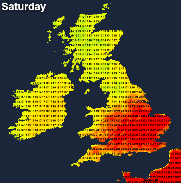
With the wetter weather in the north to end the week, the mid-teens will likely be your peak, but it should start to dry and warm up on Saturday. Sunday could potentially then bring a lot more sunshine to all parts, which would mean most of us enjoying highs comfortably into the twenties. That could help to trigger some thundery downpours later in the day though, with a showery, potentially thundery breakdown spreading through on Monday as cooler air returns.