The south staying dry and sunny Saturday, otherwise rain arriving in the north before spreading across all parts Sunday. Monday showers or longer spells of rain.
Thursday saw plenty of sunshine across the UK, with Heathrow in west London reaching 24.7C. Today will be another dry day for most, with plenty of warm sunshine on offer, though some showers will develop across Northern Ireland, Wales and into parts of southern England.
However, we will see a change in our weather over the Bank Holiday Weekend, as low pressure moves in off the Atlantic, introducing cooler and breezier conditions and also some rain across most parts by the end of Sunday, followed by showers across many areas on Monday.
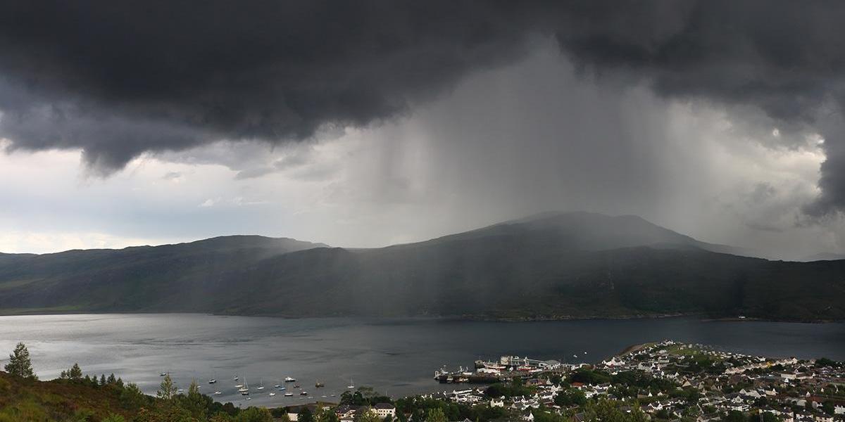
For now, most places have started Friday on a dry and fine note, with some sunshine, though there is more in the way of cloud spilling down across parts of Scotland, N. Ireland and into west Wales – which is bringing a little patchy drizzle in the far west. As we go through the morning and into the afternoon, more in the way of cloud across northern and western areas spilling southeast, with the best of the sunshine becoming confined to eastern and southeastern England. Showers developing across Northern Ireland and Wales, with these pushing southeast across parts of southern England through the afternoon too – where they may become locally heavy. A few showers also likely across northern Scotland.
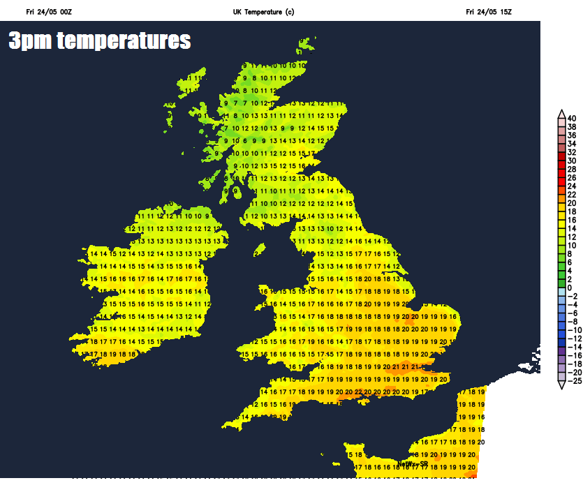
Where we see the best of the sunshine across eastern England this afternoon, temperatures reaching 19-22C, elsewhere across England and Wales we are looking at 15-19C. Across Scotland and N. Ireland highs of 11-16C.
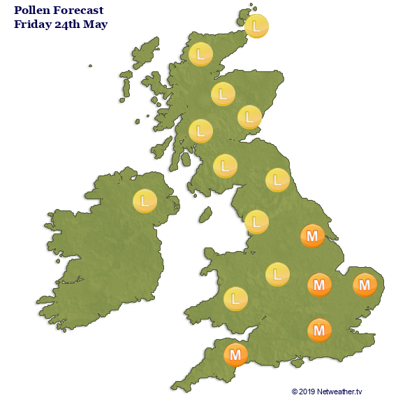
High UV levels in the sun today, so be sure to wear protection. Grass pollen levels moderate.
What's your local UV and Pollen? Find out here.
Then after today’s showers fade this evening, a largely dry night with clear spells across the bulk of the UK, cloudier across northern Scotland and perhaps NE England – where there will be some patchy light rain.
Saturday will see some decent spells of sunshine across central and southern areas of England and Wales, though a few sharp showers look to develop across the far southeast. Cloudier skies spilling down across Scotland, N. Ireland and northern England, with outbreaks of rain spilling in from the west from late morning and through the afternoon, as low pressure approaches, though south of a line from Liverpool to Hull should stay dry. Warm in the sunshine across southern England and south Wales, temperatures reaching 20-22C, elsewhere across England, Wales and N. Ireland reaching 16-19C, Scotland a cooler 10-14C.
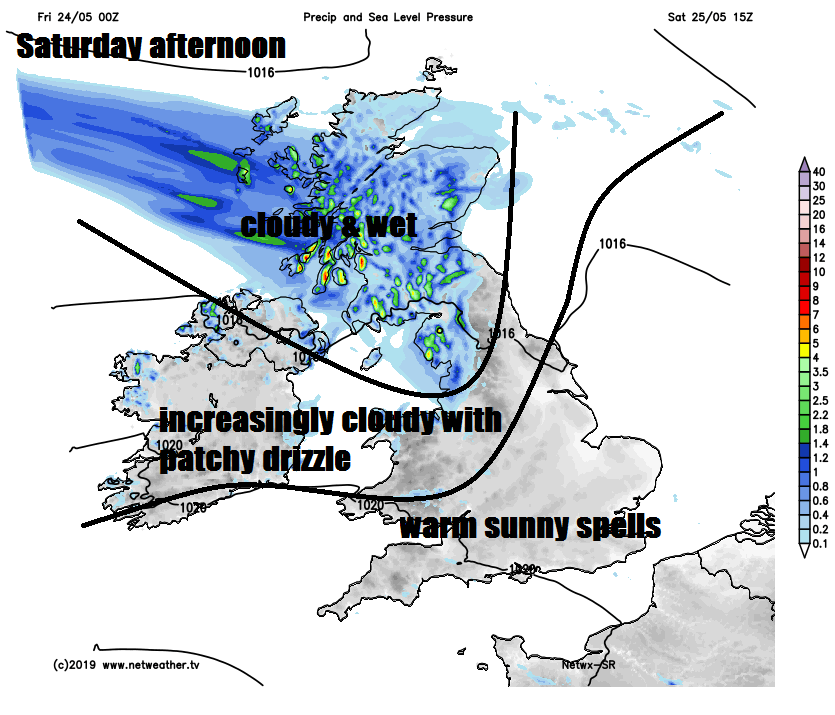
An area of low pressure will push east across Scotland Saturday night, pushing further outbreaks of locally heavy rain across Scotland and N. Ireland through the night. Rain clearing from southern Scotland and N. Ireland in the morning, though lingering across northern Scotland. A band of rain pushing southeast across England and Wales, reaching SE England and East Anglia late afternoon and early evening. Perhaps little if any rain reaching Devon and Cornwall though. Brightening up through the afternoon following the rain across western areas. Temperatures reaching 18-21C across much of England and Wales, far north of England, Scotland and N. Ireland reaching 10-16C.
Turning unsettled across all parts Sunday, rain spreading SE followed by showers or further spells of rain Monday.
The cold front spreading the band of rain southeast on Sunday will clear off into the near continent on Sunday night, introducing a cooler northwesterly flow across all parts on Monday. An area of low pressure will move southeast across northern Britain, bringing longer spells of rain here, otherwise showers spreading southeast elsewhere – some of which will be heavy and thundery. Breezy everywhere and feeling cool with temperatures reaching 10-14C in the north, 15-18C in the south.
Monday setting the scene for what will be a cooler week next week to what we’ve been used to this week, with showers across many parts on Tuesday and Wednesday, perhaps heavy and thundery, then an area of low pressure tracking across central Britain on Thursday bringing a spell of more persistent and perhaps heavy rain across many areas, followed by sunshine and showers in a cool northerly or northwesterly wind for Friday.