Windy today with bright spells and showers, storm with no name on Saturday will bring gales & heavy rain for many, snow for Scotland. Weather calming down next week as high pressure builds.
It’s set to stay windy as the week draws to a close, with bursts of showery rain but also some brighter skies for some. A deepening low tracking northeast on Saturday could bring disruption across many areas, due to snow across Scotland, gales or heavy rain across England and Wales. Sunday brighter and cooler, but still windy with a scattering of showers. The weather calming down as we head through next week, some dry and bright weather but also cloud and rain at times for many at first, but Wednesday onwards high pressure builds from the south, so many areas becoming drier and more settled.
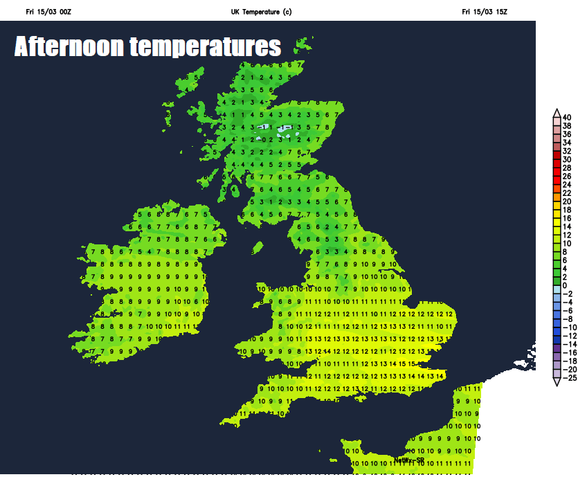
For now, it’s a generally frost-free start, temperatures in double figures to start the day across central, southern and eastern England, as high as 12-13C in places. It’s also rather windy this morning away from northern Scotland, winds gusting between 30-40mph widely, 40-50mph locally, isolated 50-60mph to the lee of the Pennines and across the far west.
For much of England and Wales it’s a windy and cloudy picture for the morning commute, mostly dry across eastern England, but across Wales and western side of England there are some showery bursts of rain. Scotland and N. Ireland brighter and colder than further south, but with a scattering of showers, heavy in places and falling as snow over higher ground.
The brighter skies across Scotland and N. Ireland should gradually shift south across northern England, north Wales, Midlands and East Anglia through the morning and into the afternoon, showers continuing across Scotland and N. Ireland, falling as snow over Scottish hills, showers also affecting northern England, but some sunny spells in between. South Wales and southern England hanging on to cloudier skies for much of the day, with patchy rain spreading from the west, thanks to a stalling frontal boundary. Staying windy through today across most areas, with gales locally, rather mild across England, Wales and N. Ireland, temperatures widely reaching 12-15C, cooler across Scotland – where temperatures will reach 5-8C.
Showers across Scotland becoming confined to western areas this evening and overnight, otherwise it will turn cold in the clearer spells, temperatures falling to a couple of degrees above freezing at lower elevations, below freezing over higher ground. Further south, cloud and outbreaks of rain will spread northeast across England, Wales and N. Ireland, turning to snow over the northern Pennines and hills of N. Ireland, but milder further south, temperatures perhaps staying in double figures across the south, but it will turn drier here after rain early in the night.
Area of low pressure tracking northeast will bring heavy rain for many on Saturday, snow over Scotland, gales across England and Wales.
Lots going on Saturday weatherwise and not in a good way for most, as a deepening area of low pressure will track northeast across Ireland in the morning then northern England in the afternoon, bringing a threat of disruption for various reasons – depending where you live. Outbreaks of heavy rain will continue to spread northeast during the morning while becoming drier and perhaps brighter but windy across southern England and East Anglia. As the rain spreads north across Scotland and N. Ireland it will bump into cold air and turn to heavy snow for a time, above 350m there could be 10-20cm of snow, but snow falling to lower levels for a time too, though tending mostly to settle above 100m.
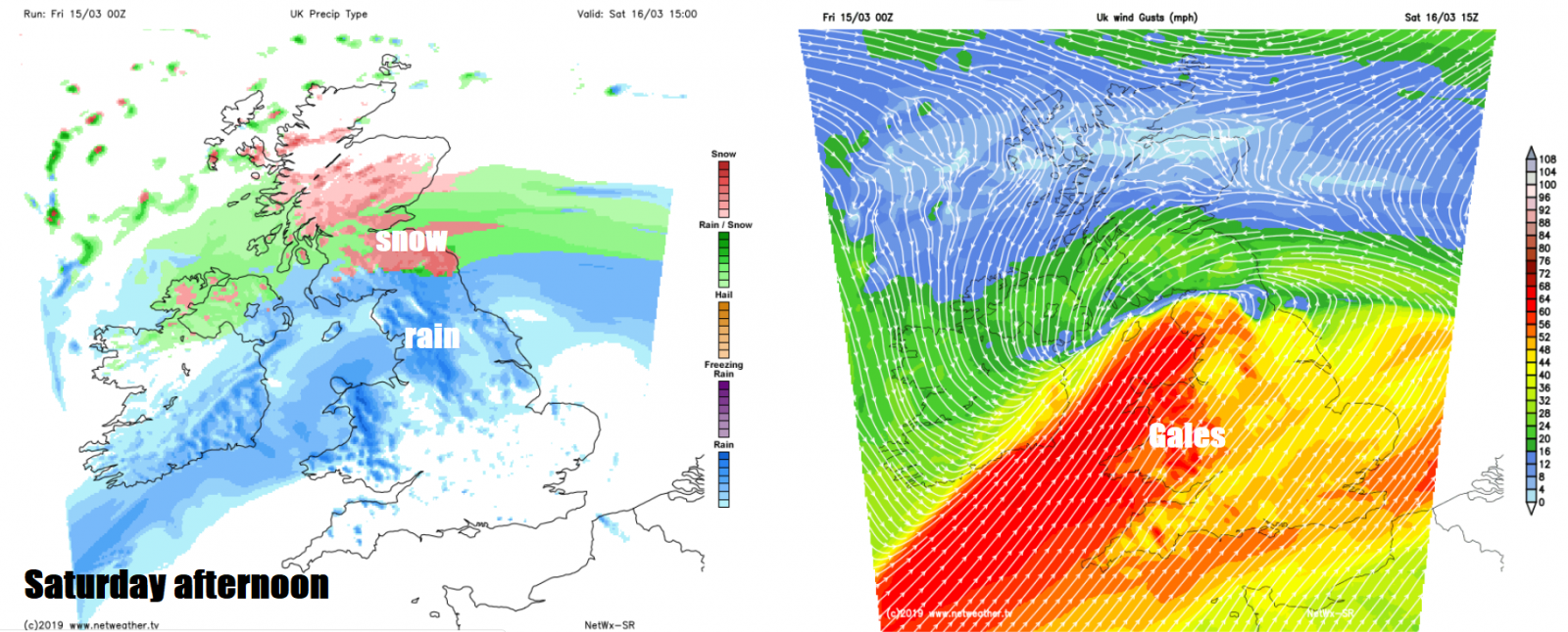
It will become rather windy to the south of the low tracking northeast, gales across England and Wales, gusts of 50-60mph likely widely inland across Wales, central and southern England, perhaps 60-70mph across exposed southern and western coasts and hills. Further persistent and heavy rain will return across NW England, Wales and SW England through the afternoon, as the cold front of the low moving northeast arrives from the west, the rain heavy over western hills here, where we could see 80-100mm by the end of the day – which may lead to an increased threat of flooding – especially Cumbria and west Wales. Cold across Scotland – where temperatures will reach 4-5C at best, but such a contrast south of the border across England, Wales and N. Ireland – where temperatures will range from 9-11C in the north to 11-13C in the south.
Thankfully the weather calming down for most as head into Sunday, as Saturday’s deepening low moves away towards Scandinavia. However, it will remain windy, particularly windy across northern and eastern Scotland as that deepening low moves away. A cool day for all in a strong northerly or northwesterly flow, with sunny spells and scattered showers spreading south, heaviest and most frequent in the north and west – falling as snow over northern hills, but eastern area could catch a shower too. Temperatures ranging between 7-9C in the north to 9-10C in the south.
Most places dry and bright or sunny on Monday, though a few showers possible towards eastern and western coasts. Cloud and rain spreading in off the Atlantic across western Scotland and N. Ireland by the evening. Cloudy and breezy on Tuesday for many, overnight rain clearing the north but cloud thick enough to bring patchy light rain or drizzle anywhere. Wednesday onwards, high pressure starts to build from the south, so after cloud and perhaps some rain initially across the north, most areas turning drier and more settled Thursday and Friday – with increasing amounts of sunshine across England and Wales, though Scotland generally cloudier. Rain and strengthening winds perhaps returning from the northwest to end Friday.