Lots of weather to watch this weekend with strong winds, persistent rain, showers and even some snow to keep an eye on.
It's currently a very mobile weather situation and typically March, as Atlantic troughs harbouring disturbances sweep-in from the West. As a result, it'll often be windy with occasional rain or showers and also some snow especially over hills in the North.
One such trough is currently giving outbreaks of rain, sleet and snow across Northern Ireland, southern Scotland and northern England, with some places mostly on hills waking to a carpet of snow this morning.
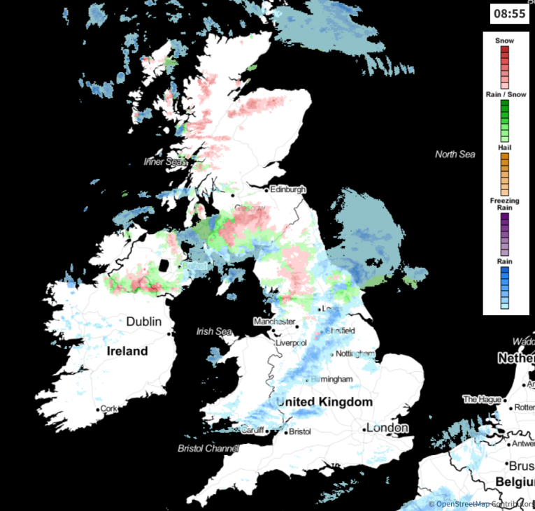 View the live weather radar here.
This'll be a temporary affair with the snow soon melting, except on the higher peaks as the sun comes through to leave fewer showers. North of the Forth/Clyde valley there'll be scattered wintry showers mostly in the West through the day, with sunny spells and just the odd passing shower further East. Across the Northern Isles, you can expect outbreaks of rain, sleet and snow for much of the day. Across remaining parts of England and Wales, there'll a line of showers crossing from West to East this morning, followed by sunny spells and fewer showers these mainly in the West. By the afternoon central and southern parts should become mostly dry, but take an umbrella just in case.
A blustery West or South West wind will give strong or gale force gusts in exposed areas and the more squally showers. This'll feel raw in the North and over Scotland where temperatures will get no higher than 4 to 7C, but across central and southern parts, a milder 9 to 12 locally 13C is more likely depending on amounts of sunshine.
The evening sees a mostly South West or southerly wind decreasing for a while with clear spells in the East before further Atlantic systems move in from the South West. These will bring outbreaks of rain and hill snow to Wales and much of central southern England during the night and also to Northern Ireland before morning, where you could well see further snow particularly over the Derry and Antrim mountains. Meanwhile, West Scotland sees further wintry showers, with the Northern Isles continuing to see rain or snow at times. In the clearer skies ahead of the incoming rain and snow there'll be a slight frost, particularly in sheltered valleys and glens, with lowest temperatures -1 to 3C in the North and East and 4 to 7C in the South and South West.
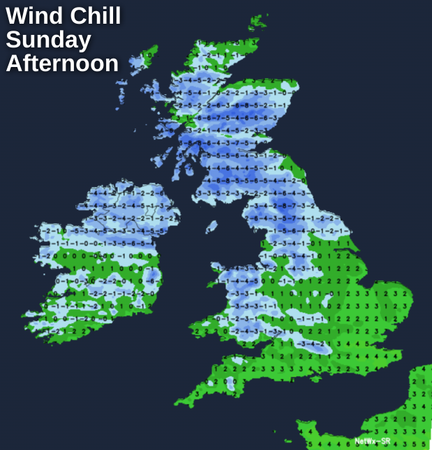
Sunday is giving forecasters a headache, with a complicated set of systems bringing a wet start to many central and southern parts. Across the North Midlands and Staffordshire Moors, some snow is possible early, before this clears away into the North Sea to leave a mixture of sunny intervals and blustery showers for the rest of the day most frequent in the West.
Across Northern Ireland, northern England and later much of central and southern Scotland showers and longer spells of rain, sleet or snow heavy in places will move in. The snow will be mostly on hills but don't be surprised to see a temporary slushy covering at lower levels for a time. Across the North of Scotland, it'll be rather cold with a scattering of wintry showers, with the Northern Isles perhaps brightening up from the North later.
Winds somewhat lighter and more variable in direction at first will freshen from the West to make it blustery particularly over central and southern parts, where gusts to severe gale force could occur along exposed coasts later.
In a colder day everywhere, top temperatures will be 4 to 6C in the North and 7 to 10C further South. The wind will make it feel colder than those values though.
Further showers are likely into the evening especially over Scotland and the North and East of England, some wintry giving mostly hill snow. Elsewhere the showers should be more scattered before fading from the West overnight as a weak ridge moves in off the Atlantic. A West then South West wind will decrease somewhat allowing it to turn cold enough for another slight frost mostly in sheltered rural parts of the North and West, with lowest temperatures mainly in the range 0 to 4C.
Monday starts fine, but there'll be more wet and windy weather moving in from the West.