Continuing unsettled for the rest of the week, with further rain for all, hill snow at times across Scotland, some sunny spells too, but also some showers with it. Turning colder on Thursday.
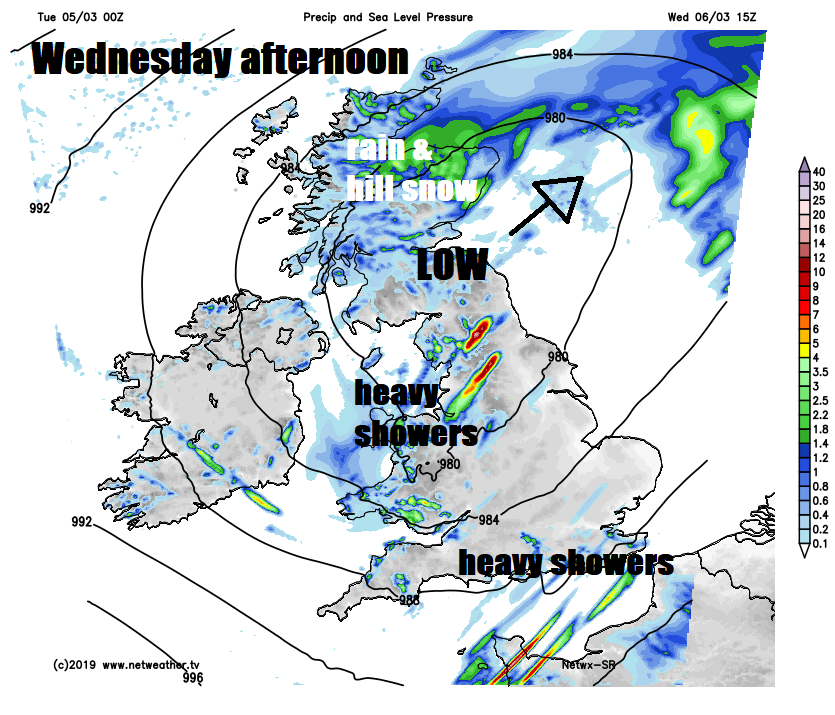
The weather has been rather turbulent since the start of the month, so certainly March has come in like a lion, with the rest of this week no exception to this unsettled theme. Which is in stark contrast to the record-breaking warm conditions to end February this time last week. Rain and hill snow will spread across Scotland, N. Ireland and NW England today, but further south it will drier and sunnier. Rain arrives across the southwest later today, as a new deepening low moves northeast, spreading rain and strong winds across many parts tonight, before becoming confined across Scotland on Wednesday, sunshine and blustery showers developing further south. Staying windy but turning colder from the north on Thursday, with bursts of showery rain and hill snow in the north moving through, breezy with showers again on Friday.
For now, clearing skies and winds easing overnight following yesterday’s fading showers means a chilly but bright start for many, especially across northern and eastern areas, with temperatures close to freezing bringing a touch of frost in places. Temperatures are lowest across NE Scotland – where they have fallen to -6C at Aboyne. However, across the northwest cloudier skies spreading in from the west has brought rain and hill snow to start the day across N. Ireland, NW England and SW Scotland.
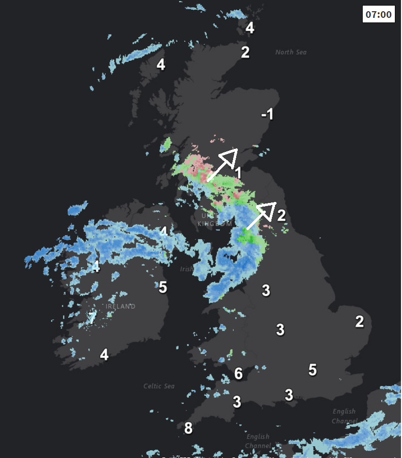
Showery outbreaks of rain and hill snow will continue to spread northeast across Scotland during today, snow mostly falling over the Highlands with rain towards coasts. Early rain clearing N. Ireland and NW England to sunny skies and just a few showers. But for rest of England and Wales it’s a generally dry and bright or sunny picture today, milder in the south too. However, cloud will increase across the south and southwest, heralding outbreaks of rain spreading in across SW England and Wales late afternoon, then across SE England and Midlands by the evening rush hour.
Cold across Scotland, where temperatures look to reach 7-8C at best, milder for N. Ireland, England and Wales, with highs of 10-13C.
A deepening area of low pressure will track northeast up through the Irish Sea towards SW Scotland tonight, spreading wet and windy conditions north across many parts overnight, the rain heaviest across northern and western areas, turning to snow over higher ground of Scotland. The north of Scotland probably staying dry, clear and frosty, while clearer but showery conditions arrive across the southwest to end the night.
So, a wet and windy start to Wednesday for many, but any lingering overnight rain should quickly clear east from most of England and Wales, to sunny spells and blustery, perhaps thundery, heavy showers for the rest of the day, but remaining windy. Rain and hill snow lingering across much of Scotland though, particularly north of the central belt. Colder across Scotland and N. Ireland, with 6-8C the highs, but across England and Wales It’ll be milder, with temperatures reaching 11-13C.
Colder air sweeping south across many parts on Thursday, possible gale force northerly down eastern coasts in the northeast at first, the strong wind blowing scattered showers south across many parts, wintry in the north, with snow over higher ground. Sunny spells between the showers.

Friday sees the wind swing back to more of a westerly but still brisk, so after a cold and frosty start to the morning looking mostly dry and bright, but showery rain looks to spread in from the west across quite a few areas by the evening.
The weekend continuing the unsettled theme, with one or two Atlantic depressions, perhaps deep, rolling in and crossing the UK, bringing wet and windy conditions at some point or showers, however, the track of these lows is uncertain this far off, so stay tuned.