Winter in the weather world is Dec/Jan/Feb. This February has been like summer at times. March and meteorological spring arrives tomorrow as the temperatures fall away and it all turns unsettled.
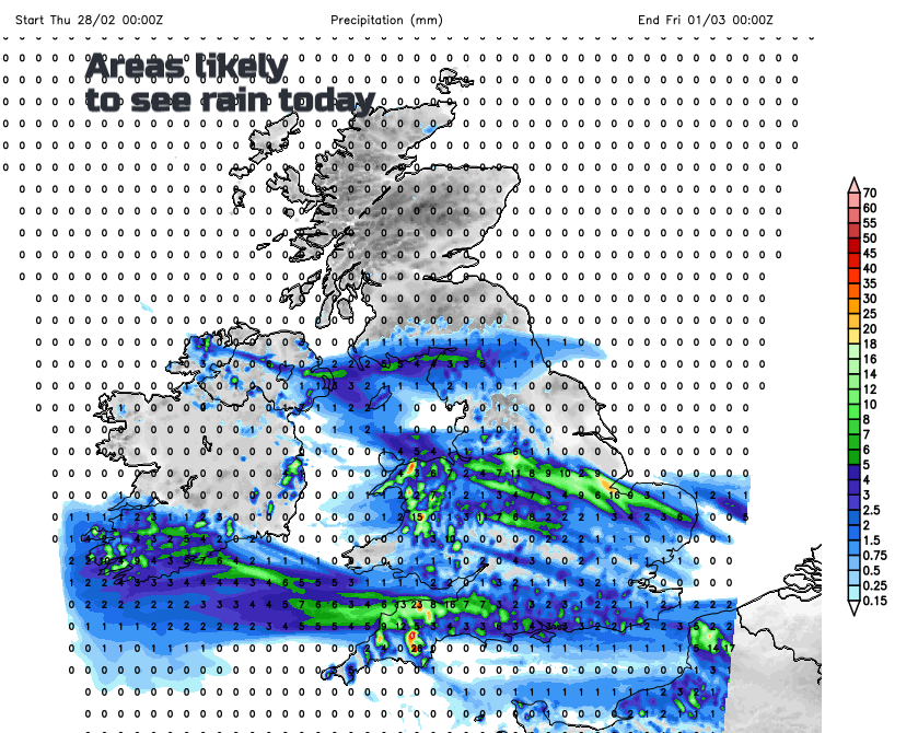
We won’t see such high temperatures today or as much sunshine. In fact, there is already rain for Wales, Ireland and SW Britain with showery outbreaks heading over England today. The exceptionally mild and sunny spell is over, with temperatures falling as we head into March tomorrow and the weather will become more unsettled with wind and rain at the weekend.
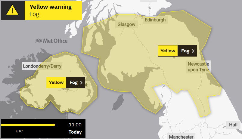
There are fog warnings this morning from the UK Met Office, highlighting Northern Ireland, southern Scotland and northern England
Yesterday the top temperature was at Heathrow, a meagre 19.2C after this week’s dizzy heights of the new UK February record on Tuesday of 21.2C (70F) at Kew. Aboyne reached 18.2C, a week after the long-standing record had been broken, same place with 18.3C. Quite a phenomenal run of warmth and dry, sunny weather. The fire service has been dealing with some of the wildfires across Britain and Ireland.
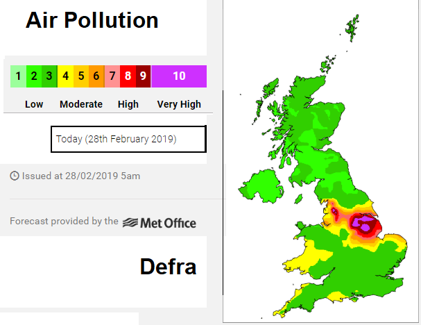
Air pollution levels will fall as the brisk Atlantic flow picks up but there are still concerns and very high levels of pollution for northern and eastern England possible today. Under the recent area of high pressure, the air has stagnated as the slowly descending, still, anticyclonic air just traps all the particles and pollutants. Then levels rise. There is a chilly, still start here with brighter skies. As the weather changes and the flow picks up from the west, fresher air will arrive but there are concerns for today.
So, for the rest of this week temperatures will be lower but back to where they should be at this time of year 7 to 9C is about average and we’ll see 7 to 12C so still not bad. Just compared to the recent spell, it will seem cooler. It’s not cold though but there are signs that wintry precipitation will return to the hills and mountains.
Today
This is the last day of meteorological winter. The actual weather has other plans. Bands of showery rain will spread towards SE England later today. So patchy rain for parts of Wales, England, a bit for Northern Ireland and just into southern Scotland. It’s not much but will be a quite a change with increasing cloud cover. Much of the UK still has light winds but a westerly breeze has picked up in the far south and this will become noticeable for southern England and East Anglia by this afternoon. For much of Scotland and Northern Ireland, it will be grey, even murky with the calm conditions and more cloud. There will be brighter spells for western Scotland with temperatures of 8 to 10C. Around 9 to 11C for Northern Ireland and 9 to 12C for England and Wales although eastern England could see up to 14C with a little sunshine.
Pressure rises a bit overnight allowing a settled start for Friday. There will be sunshine during Friday morning for Northern Ireland and western Britain, more cloud even dampness further east. Temperatures will be around 8 to 12C before a southerly wind picks up and rain arrives over Ireland.
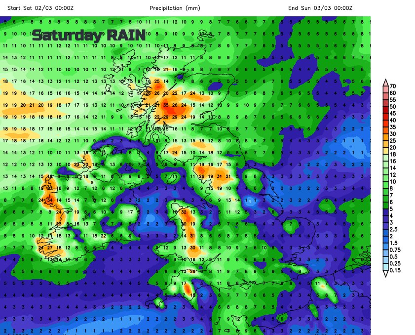
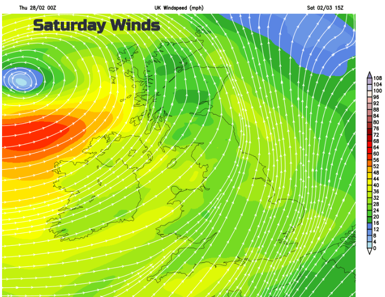
The rain looks to be over Northern Ireland and western Britain on Friday night and then an area of low pressure heads close to the UK from the Atlantic during Saturday. This will bring windy weather across the UK, gales in the far NW and proper rain as the February warmth and sunshine is well and truly erased.
Next week looks colder everywhere with rain, sleet and hill snow. Put your winter coat back on.