21.2C on Tuesday, a new UK February record at Kew Gardens. Fine again today but gradual changes this week as the temperatures slide. Looking wet, windy even wintry over the hilltops for the start of March.
Well, what a day, what a month! And similar today; sunny, dry and warm. Tuesday 27th saw February records being broken again for England, Wales and the UK. 21.2C at Kew Gardens, London around 3pm and 20.8C for Porthmadog, Gwynedd. The warmest winter day on record in the UK. It was dry everywhere, sunny for most of the UK and so unlike an average February day where temperatures should be around 7 to 9C.

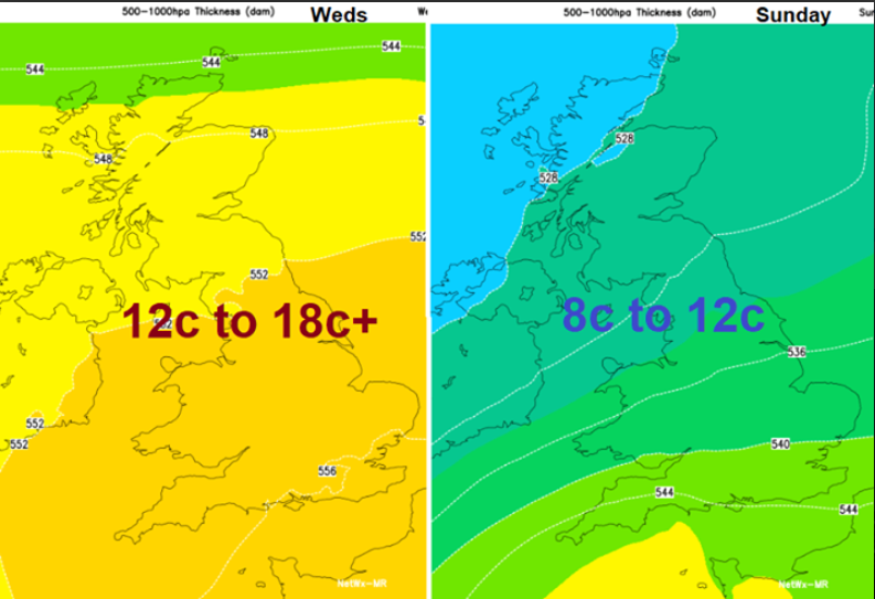
There is a change in sight and rain too. By the end of the weekend, most places will have had some rain, it’s been dry for so long. The high pressure gives up its lasting hold settled over the Mediterranean instead and we get back to an Atlantic flow with blustery winds, outbreaks of rain and we lose this flow of exceptionally mild air.
Today will be another warm, dry and sunny day. There is a bit of fog about this morning and some low cloud. It’s been chilly again with the clear skies overnight so another nippy start. There have been dramatic pictures overnight from gorse fires burning in several locations after this lengthy dry spell
John explains about the white on the ground - "It was the damp on the grass reflected in my headlights and the salt on the road from the snowfall a couple of weeks ago".
There is a bit more cloud in the far north of Scotland with rain for Shetland. Elsewhere it’s another fine day with very light south to SW winds. The temperatures climb once more but the winds will veer slightly, so places like Porthmadog won’t feel the Foehn Effect today, resulting in warmer, drier air spilling over high ground.
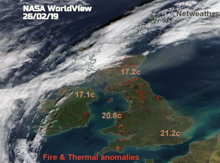
Highest temperatures yesterday, the clear skies over most of the UK and red spots showing heat spikes/ wildfires
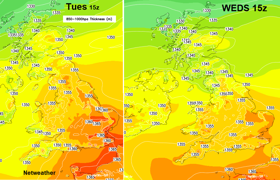
Southeast England will see high temperatures 17 to 19, 20C likely again. The is still quite a loss of heat overnight in February from towns and cities, not like in summer where the concrete can store the day’s warmth during the short night. The air is slightly different today, as shown on the thickness chart but not much. Temperatures are already leaping up from -1C to +10C around London in an hour as the sun gets to work. Eastern Britain also seeing mid to high teens today, also Somerset.
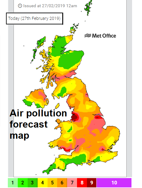
This settled, dry spell leads to stagnant air. Air pollution levels are rising, with some alarming values being recorded roadside in cities.
DEFRA –“Widespread areas of Moderate, locally High air pollution are forecast today for much of the UK, except most of the northern half of Scotland, and also parts of southwest England. This is considered to be from a mixture of locally generated and continental sources combined with light winds.”
Tomorrow looks more cloudy. Low cloud will have filled in the Irish Sea overnight, there are frontal bands heading into SW Britain for Thursday morning and even after a fine start for central, northern and eastern England, the cloud will increase from the SW. There will be a few showery outbreaks of rain for Wales, maybe brushing Northern Ireland and across southern England but quite isolated. A change certainly from recent days but not reliable rain for the land.
Later in the day, there will be more showers for SE England then they drift away across the Channel. It won’t be as warm tomorrow, still not bad but just not what we have been experiencing and there will be a westerly breeze for southern Britain. It will feel different with the cloud and the wind.
Friday will have cloudy skies with bright spells. A cold front approaches from the west bringing more cloud and a distinct band of rain. The southerly winds pick up around western coasts and the rain begins to work its way across Britain during Friday night., It will be heavy for western hills but fading by the time it reaches eastern counties.
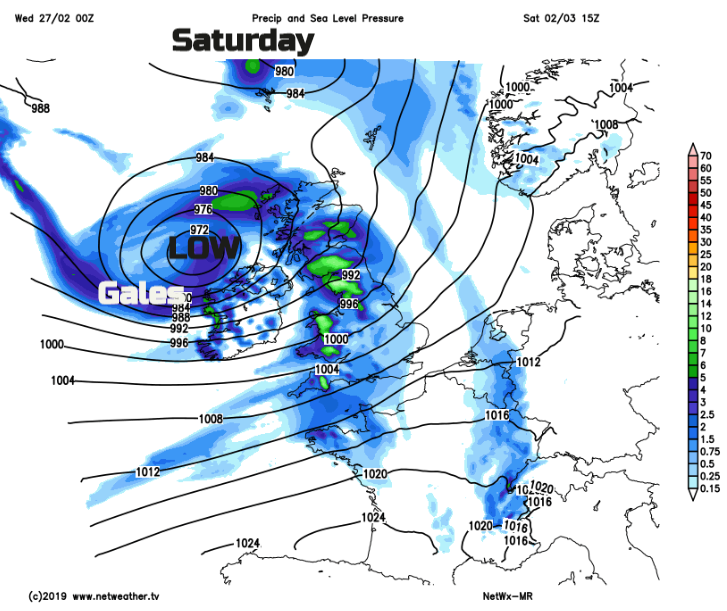
That band fades as a deepening area of low pressure barrels in from the west, bringing more heavy rain and strong winds for Saturday. It had to do this at the weekend, didn’t it? And there will be snow over the hill tops. A reminder of what time of year it really is.
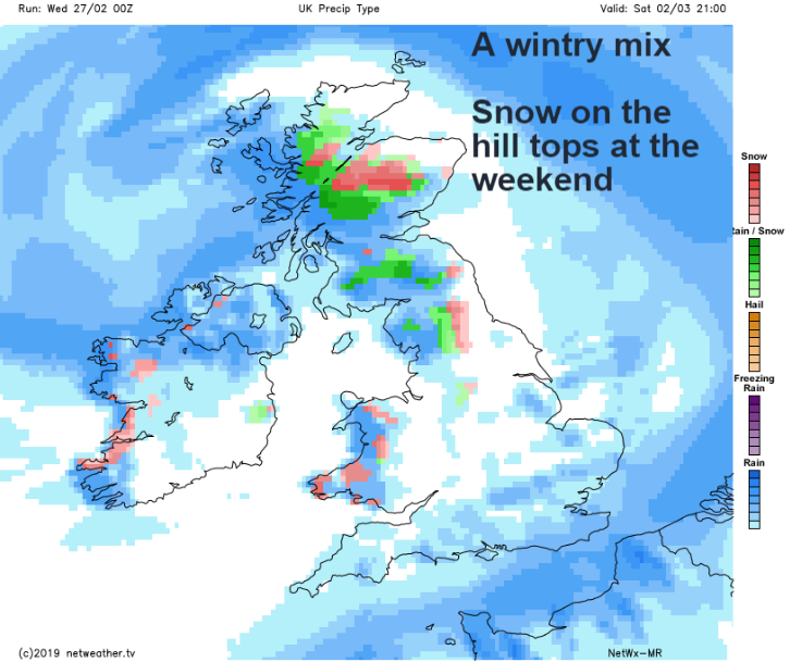
As the low pressure pulls away to the NE as the winds ease off a bit but there is more rain lurking to the south which could move over southern Britain during Sunday or Sunday night. That could also bring a bit of snow to the Brecons as the start of March brings a very different theme to February.