Another exceptionally mild day today, temperatures reaching high teens in places, potential we could beat yesterday's 20.6C in Wales. Turning unsettled and cooler from Thursday.
In what has been an exceptionally mild spell for winter this month, yesterday was both the warmest UK February day and also the warmest UK day of any winter month since records began. The new record holder is Traswsgoed in west Wales, which reached 20.6C, beating the previous record of 19.7C set at Greenwich, London in February 1998.
With high pressure still in control on the near continent on Tuesday, temperatures will likely again reach the mid-to-high teens, with a few spots across England and Wales again reaching 19-20C. Another very mild day on Wednesday too, though perhaps one or two degrees lower, so the exceptionally mild temperatures peaking today. Then for the rest of the week, temperatures will begin to lower into the low teens, as the jet stream begins to take more of an aim at the UK, rather the diverting well to the north, introducing less settled, cooler and windier conditions off the Atlantic, with sets of weather fronts pushing rain eastwards.
Change by the weekend, as the jet stream that's been way to the north takes aim at the UK - bringing wind, rain and cooler air.
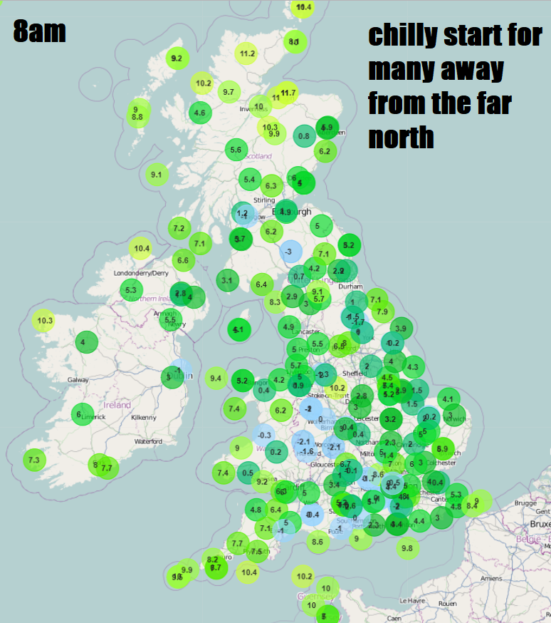
For now, the still long nights, clear skies and dry air has meant temperatures across many parts away from northern Scotland have dipped into low single figures and in places below freezing, so it’s a cold and, in places, frosty start. Blue skies for many to start Tuesday, away from NW Scotland where there is more in the way of cloud, though there are some mist and fog patches to watch out for.
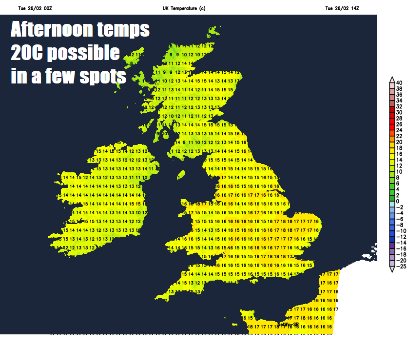
For most it will stay dry with prolonged warm sunshine under blue skies today, the exception will be across the far north and northwest of Scotland and the Northern Isles – where it will often be cloudy. Like yesterday, exceptionally mild for late February in generally light winds and unbroken sunshine, temperatures away from northern Scotland widely reaching the mid-teens, but quite a few spots across England and Wales will likely reach the high teens, with 19-20C possible again across southern England and parts of Wales. Possibility that yesterday’s new record high for February may be surpassed too.
Dry overnight again, with clear spells for many, but we will see more in the way of fog forming overnight across southern areas of England and Wales, as more moisture returns from the south. Turning chilly or cold overnight, with some local patches of frost, but not as cold as last night.
So many starting Wednesday on a dry and fine note, areas of fog, perhaps locally dense, across southern areas of England and Wales should slowly burn off to sunshine through the morning, to join many areas to a dry and sunny day. However, Ireland, Northern Ireland and western most areas of mainland Britain will see low cloud drift in to bring a grey day, which will peg back temperatures to the low teens. In the sunshine further east, temperatures reaching the mid-teens, perhaps 18C across SE England, but as you may notice, temperatures a few degrees down on todays.
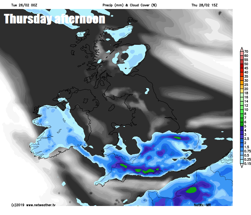
Then we see a change evolve from Thursday, as the blocking high pressure over mainland Europe that has dominated our weather for a while slips away to the south. This will allow Atlantic fronts to move in from the west on Thursday, bringing cloudier skies than we’ve seen recently, perhaps some mist and fog lingering from overnight then a dull day with outbreaks of rain forecast to move eastwards across N. Ireland, Wales and parts of central and southern England, though some uncertainty how far north. Some rain also reaching western Scotland later in the day. Maybe brightening up across the southwest to end the day. But temperatures noticeably lower than recent days, reaching 10-12C at best, but still above average.
A brief ridge of high pressure looks to build in for Friday, so dry for most, with some bright or sunny spells developing. Cloud thickening across the west in the afternoon, heralding Atlantic frontal system bringing in a band of rain overnight here, before spreading east but weakening on Saturday morning.
Models show a deep area of low pressure approaching the northwest later on Saturday, so likely turning wet and windy from the west through the day across all parts. The low clearing Sunday morning to windy and showery conditions, but perhaps another low heading off the Atlantic bringing an area of rain across the south by the evening, but uncertainty this far away.