Storm Erik will sweep in gales and heavy rain, severe gales tonight across the north. Saturday windy with sunshine and showers, rain in the south Sunday, turning colder as winds turn northerly.
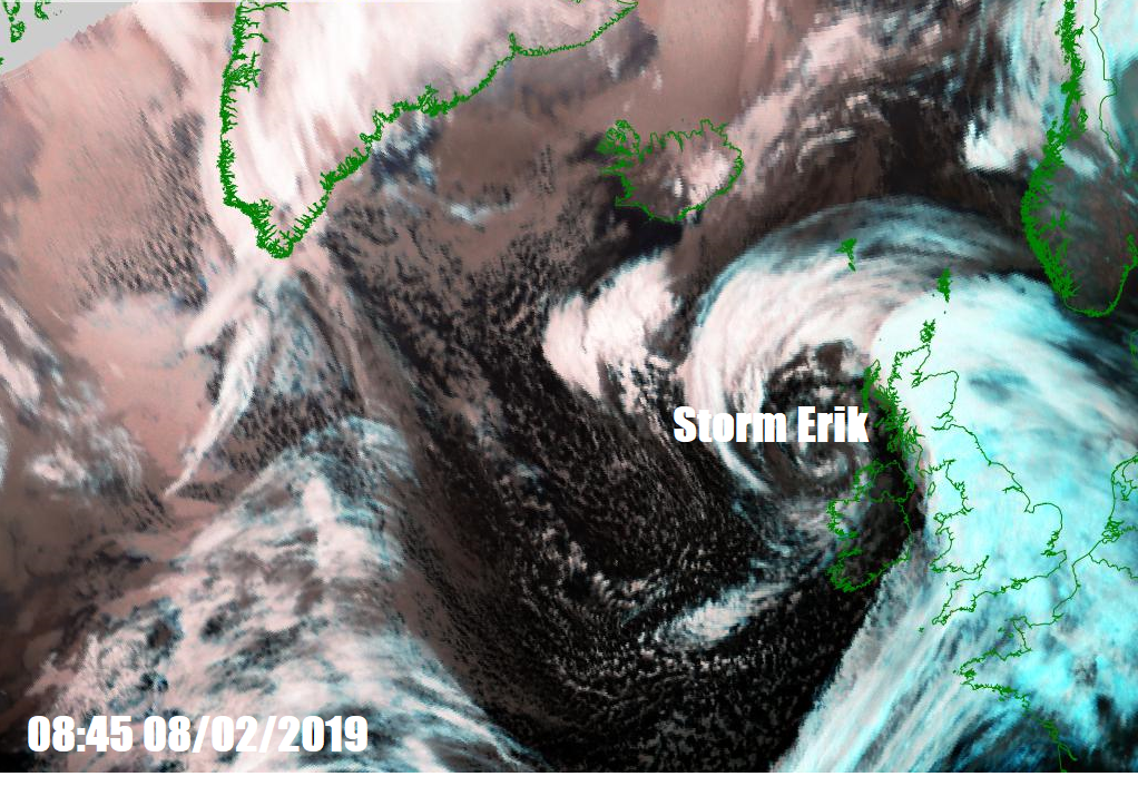
There will be some rather unsettled and windy weather over the next few days, Storm Erik, named by the Irish Met Eireann, will slowly move northeast close to the northwest today and tonight bringing gales and heavy rain across all parts, severe gales in the north and west later today and overnight. It will remain windy on Saturday, with gales and persistent rain across Scotland, sunshine and showers elsewhere. More persistent rain arriving across southern England, Midlands and Wales Saturday night and continuing through Sunday before clearing in the evening, winds turning northerly bringing wintry showers in the north and becoming colder across all parts through the day, leading to widespread frost Sunday night as skies clear. Next week likely to see high pressure build, bringing drier and mostly fine weather, nights cold and frosty.
For now, a blustery, grey and wet start for many, as outbreaks of rain spread in from the west this morning. The rain is heavy and persistent across northern and western areas for the morning commute, which combined with a strong to gale force southerly wind, will make for some difficult driving conditions. Some patchy rain across eastern England before the heavy rain across the west this morning spreads east to reach here in the afternoon, accompanied by winds gusting to 40-50mph.
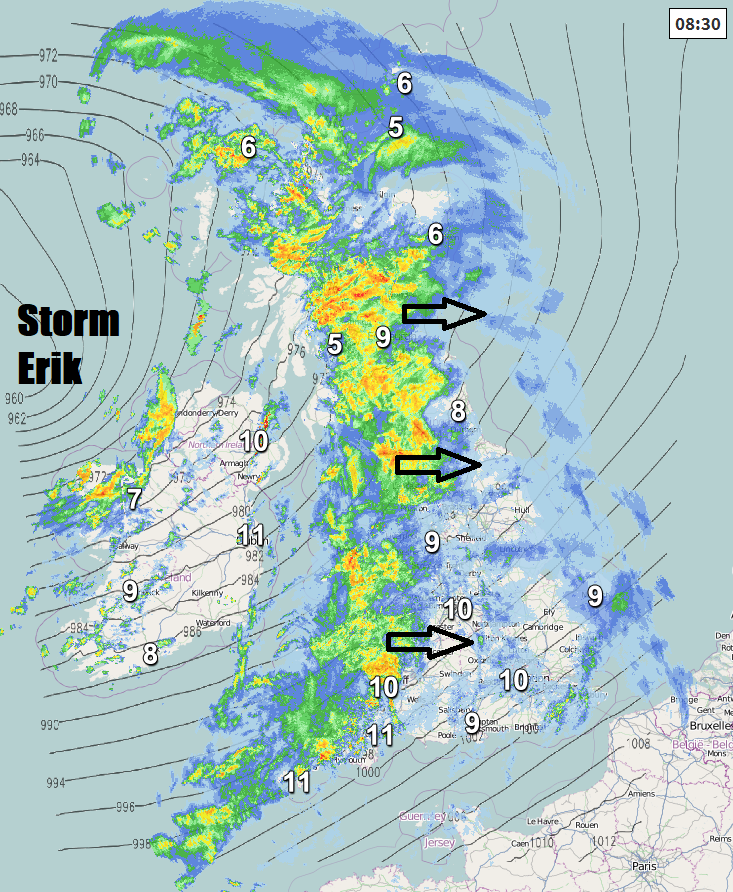
Brighter skies but also some blustery showers following the morning rain across SW England, Wales, northern England and N. Ireland. But we will hang on to outbreaks of more persistent and locally heavy rain across Scotland, swirling around the centre of Storm Erik passing close to NW Scotland, 20-30mm likely widely, but locally up to 60mm over higher ground, which combined with snow melt, could cause some flooding.
Remaining windy with gales into the afternoon and, if anything, winds strengthening across the north this afternoon and evening, with gusts of 50-60mph across N. Ireland and Scotland, perhaps 70mph or more over exposed coasts and hills.
.gif)
A mild day due to the southerly or southwesterly wind, reaching double figures widely away from northern Scotland, 10-11C the highs this afternoon, though the strong wind may make it feel cooler than this.
Rain clearing eastern England this evening, then clear spells and a few showers here overnight. Blustery showers continuing in the west, persistent rain continuing across central and northern Scotland and also affecting N. Ireland, staying very windy overnight with gales in places, severe gales locally across northern areas, with gusts of 60-70mph over coasts and hills of Scotland and N. Ireland.
Overnight persistent rain clearing southeast from Scotland and N. Ireland first thing with sunny spells and showers following for the rest of the day, but gales continuing here, locally severe gales before easing through the afternoon, as Storm Erik slowly clears northeast. England and Wales seeing sunshine and showers, locally heavy and perhaps thundery in the west, very windy at first before easing later. A mild day, temperatures reaching 7-9C across Scotland and N. Ireland, 9-11C across England and Wales.
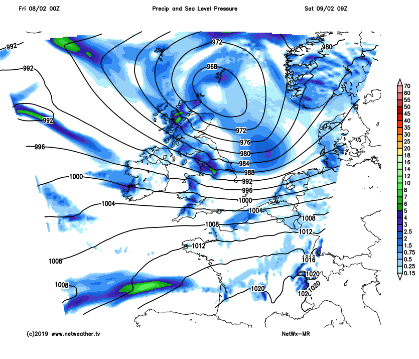
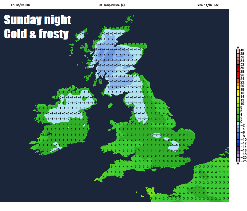
Outbreaks of rain moving in from the southwest across Wales, Midlands and southern England Saturday evening and night, then lingering across southern England, Midlands and East Anglia on Sunday before eventually clearing southeast in the evening. Brighter but colder conditions further north across northern England, N. Ireland and Scotland, as winds turn northwesterly then eventually northerly, bands of wintry showers spreading down across Scotland, N. Ireland and eventually northern England. These colder and clearer conditions spreading across all parts Sunday night, which will lead to a widespread frost developing. Temperatures falling back into single figures by Sunday afternoon, 6-7C generally, perhaps hanging on to 8-9C across the southwest.
High pressure building in from the west as we start next week, so any showers tending to fade and for many it will be a dry, bright, cold and frosty start on Monday, followed by a mostly fine and sunny day, with temperatures reaching close to the seasonal average. High pressure will likely dominate UK weather for rest of the week, generally centred over the near continent but perhaps slowly drifting north by the end of the week. So, for most it will be fine and generally bright or sunny by day and not particularly cold, but with cold and frosty nights. The northwest always at risk of Atlantic frontal systems encroaching here and bringing cloud and rain at times and here and the west generally seeing the mildest temperatures through the week, eastern areas cooler.