Blustery today for all but Scotland before a new low pressure heads in for Friday bringing stronger winds and gales into Saturday. Storm Erik
Update 11am Low on Friday has now been named #StormErik by Met Eireann
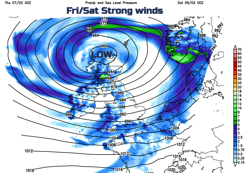
We'll see a particularly unsettled spell of weather in the run up to and during the coming weekend that although at times will be very mild, will also see temperature variations. You can expect some heavy rain, snow in the North mostly on hills and severe gales that could well produce some damaging gusts in excess of 70mph in exposed areas.
It's a wet start this morning with outbreaks of rain and mostly hill snow, from North Wales and the North Midlands northward. Some of the rain is heavy, before this clears from the West by early afternoon. All parts will then be in the 'same boat', with a mix of sunny intervals and showers. These will be most frequent over the North and West of Scotland some heavy giving hill snow, local hail and thunder. East Scotland, however, should see fewer showers and more in the way of sunny intervals. Winds here generally light at first, will freshen from the South West through the day.
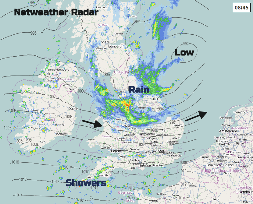
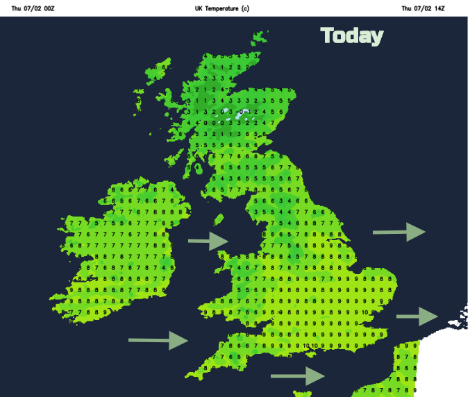
Further South and across central and southern parts, it's a different story with very strong winds on the southern edge of a depression over Scotland at first. There have been gusts of over 70mph recently, (79mph at The Needles). It's particularly windy around The Wash at the moment, with further gusts in excess of gale force expected for a while from the West or South West before winds moderate a little through the day. This'll bring blustery showers most frequent over Northern Ireland and in the West where some will be heavy. The wind will also blow a few showers further East but here they'll be fewer, quickly passing by on the stiff breeze. It'll be colder in the North where it's not much above freezing at the moment, but temperatures will eventually reach 5 to 7C over Scotland and 8 to 10C further South.
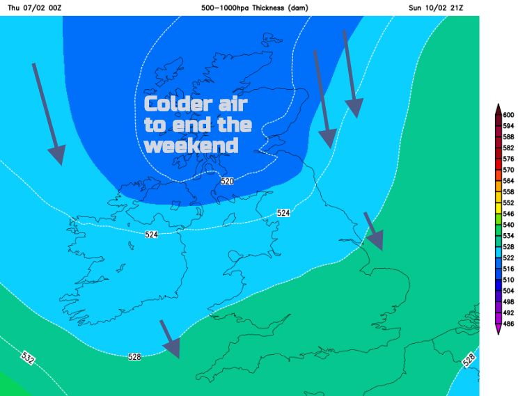
The showers will fade into the evening and as winds decrease a little further, there'll be somewhat of a lull. There'll be a few clear intervals in eastern areas giving a touch of frost in sheltered valleys and glens for a while, before more Atlantic systems begin to move in bringing cloud and rain to Northern Ireland, parts of Wales and the South West probably before mid-night. This then works its way steadily North and eastwards during the night bringing some rain to all but northern parts of Scotland by dawn. Winds will begin to freshen again from the South later in the night, with renewed gales in the West by dawn. Lowest temperatures 1 to 3C in the East, but 4 to 7C elsewhere.
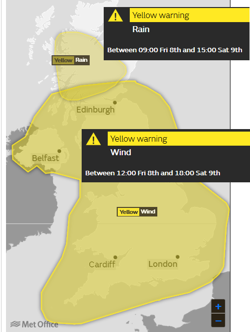
Friday sees a deepening Atlantic depression passing just to the North West of Scotland, bringing rain and gales to all parts. The North of Scotland will probably start dry, but rain will soon arrive preceded by snow mostly on hills, before milder air arrives from the South. For most though, it'll be cloudy, very windy and wet, with the rain patchy in the East at first, heavy at times especially in the North and West. A strong to gale South to South Westerly wind, will give severe gale even storm force gusts in excess of 65mph in exposed areas later, with the more general rain being replaced from the West through the afternoon by blustery or squally showers. After a cold start over the North of Scotland most parts become very mild, with temperatures reaching 5 to 7C in the far North and 8 to 11C more generally but despite this, it'll probably feel quite chilly in the very boisterous conditions.
With a deep and very vigorous depression just to the North of Scotland, all parts will have a very windy, even stormy Friday evening and night. A strong to gale South West wind will give damaging gusts in excess of 70mph in the West and over exposed coasts and hills and will also bring squally showers. Most places will see them but the showers will be most frequent in the West some heavy, giving local hail and perhaps thunder and through the night, they'll be turning increasingly wintry on northern hills. While a touch of ground frost is possible in a few well sheltered rural eastern valleys, the strong wind will help to prevent temperatures from generally not falling below 2 to 6C.
More discussion in the forum about Friday/Saturday's stormy weather