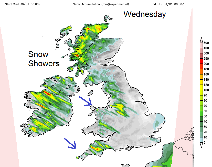
Another cold start with frost and ice after yesterday's rain and snow. A few snow showers from the west today but another threat of snow Thursday pm into Friday, from the SW.
It’s cold out there this morning with frost and ice. Aberdeenshire saw temperatures down to -9C and snow showers continue to blow in from the west. For Merseyside and Manchester, Wales, SW England, N and W Scotland and Northern Ireland. A swirl of showers continues today over Highland and western Scotland with clusters of showers working their way inland on the NW breeze, say to the Peak District and moors of NW and SW, giving more of a covering.
SE Britain saw a band of rain and some snow later on Tuesday. That either caused excitement or disappointment. If you had been expecting a “snowbomb” then change where you get your weather info from. There was a lot of uncertainty about Tuesday’s forecast but those in the media using “snowbomb” did not help with the overall weather message.
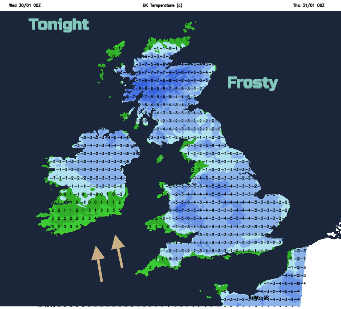
So, a quieter day, away from the feed of snow showers in the west with sunshine and a chill in the air. It will turn cold this evening with a frost once more. Daytime temperatures will be around 3 to 5C and it could be even colder tonight than last night. Aberdeenshire fell to -9C during Tuesday night.
There are more weather warnings out for Thursday into Friday. A frontal system will move up from the SW against the cold air over the UK. This will bring heavy rain to Cornwall but is likely to turn to snow as the band moves northwards. Again, there is some uncertainty about how far north the band will reach before it pivots away SE. Also, which areas will see the transition from rain to snow.
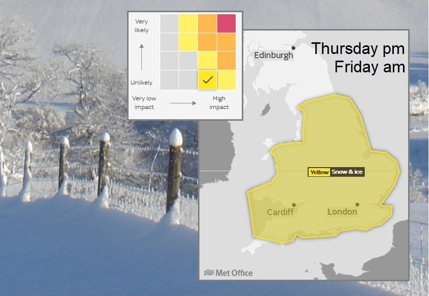
The Met Office has a weather warning covering much of England and Wales. Areas affect may differ, the yellow area is not a cut off for snow or rain, just the main area of concern for impacts from severe weather. The wet and wintry weather may not reach to the northern part of this warning area and the snow amounts will vary. The warning will be updated late morning, but currently the matrix shows low confidence but medium/high impacts if it does happen.
“Rain and snow are expected to move in from the southwest, moving across England and Wales through Thursday into Friday. This is likely to fall as heavy rain at first across the far southwest of England, but as it meets the cold air established over the rest of the country snow becomes more likely. There is a chance of 2-5cm of snow for some places, timings are currently uncertain... there is uncertainty at this stage on where is most likely to see greater snowfall accumulations.” Met Office issued 29th
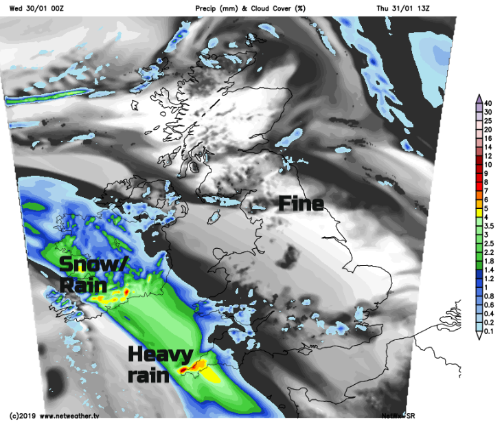
The southeast winds will freshen, becoming strong for SW England and south Wales before veering to the west around teatime on Thursday. The main rain band should be over Cornwall by midday and southern Ireland.
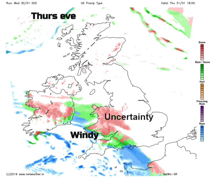
There are different solutions showing rain along south coast and sleet/snow over southern half of Wales and southern counties of England, particularly the hills. Or the band extending further north over more of Wales and the Midlands. Overnight it could reach up into Yorkshire and north Midlands as the wintry mix reaches SE Britain with a cold easterly wind. Clear, cold and frosty further north.
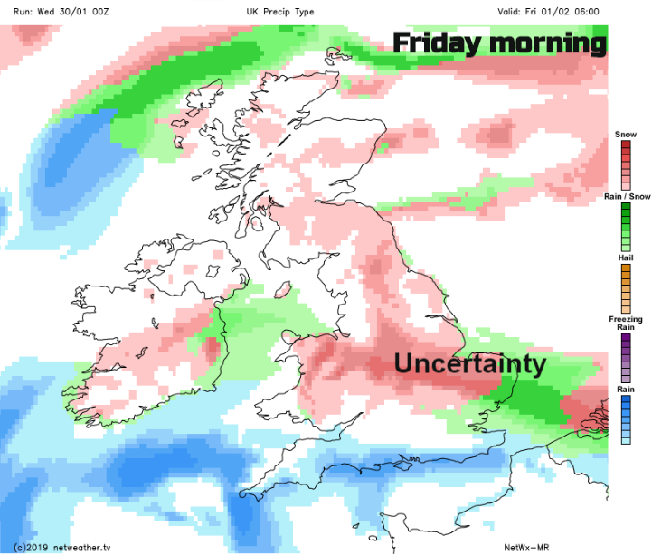
By Friday morning, the wintry band could still be stretching across southern Britain from Wales through the Midlands into East Anglia. Again, uncertainty about the positioning north-south of the band and amounts of snow, so bear that in mind if looking at an app. As the frontal band fades, there will still be wintry showers off the North Sea for eastern England in a brisk NE wind and snow showers from the NW for Scotland. It will feel very cold again by Friday evening.