Parts of the UK have already seen snow today, as a band of rain then snow makes its way E/SE. Much colder air takes hold as snow showers from the west and ice returns tonight
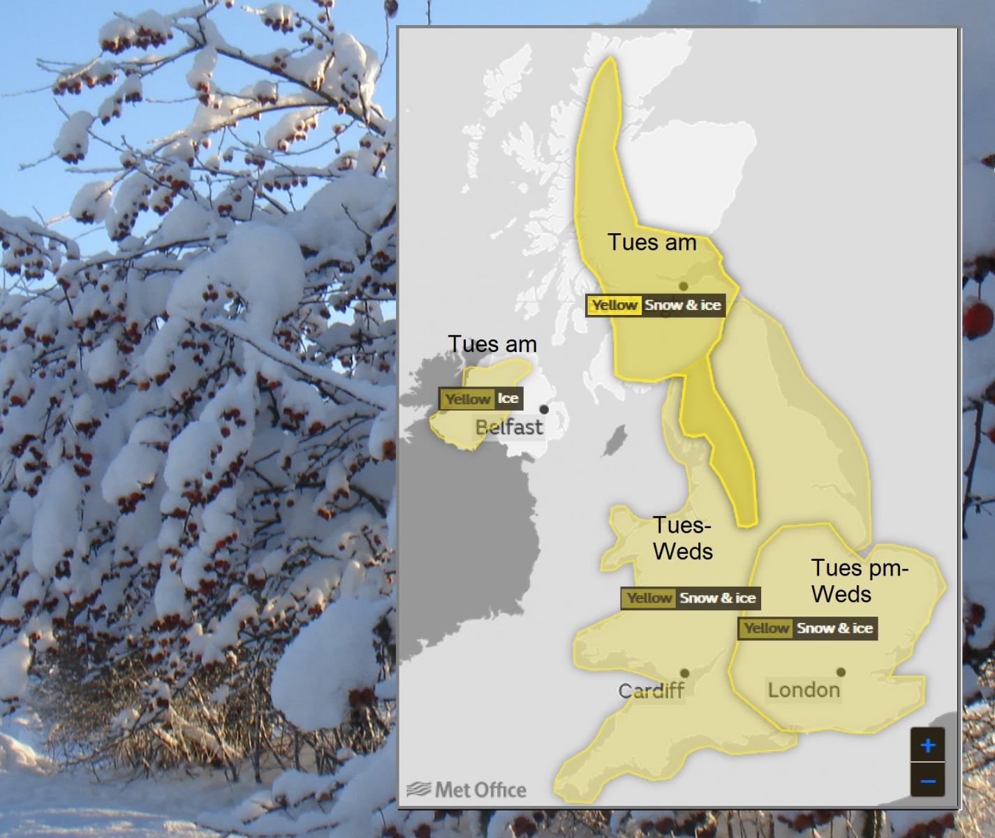
The weather remains in an unsettled mood despite yesterday's sunshine and with the air still of polar origin, there are already a number of yellow warnings of snow and ice across the country. While the polar air continues to be modified by the Atlantic Ocean, it'll still be cold enough for snow in places today. This'll be mostly on hills at first but with snow increasingly falling at lower levels later in the day, as a trough works it's way steadily eastwards across England and Wales.
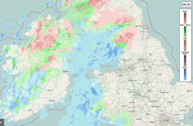
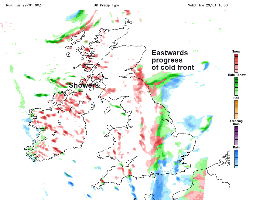
Central and eastern areas begin Tuesday fine and frosty, but with increasing cloud. This has already brought a mixture of rain, sleet and mostly hill snow to North West and parts of North East England, West Wales, the South West and Northern Ireland, that'll soon clear from the province to leave just a few wintry showers. Many more western areas should also improve through the afternoon, with the rain, sleet and mostly hill snow, spreading to the remainder of northern England, Wales and much of the Midlands through the day. Initially, most places will see rain but as this moves into Lincolnshire and the East Midlands, the rain could turn to snow even at lower levels by dusk. This could a few problems in hilly areas by the rush hour, with East Anglia and the South East probably staying dry until nightfall.
Scotland after some early rain and snow towards Fife, Lothian and The Borders have a day of sunny spells and wintry showers. These will be most frequent and heaviest in the North and West many of which will fall as snow, with eastern areas seeing fewer showers and the best of the sunshine. A mostly light or moderate Westerly wind will turn into the South West or South ahead of the rain across England and Wales making it feel particularly raw. As a result, temperatures will generally get no higher 3 to 5C, with thermometer close to or only just above freezing-point where you see sleet or snow.
The rain, sleet and snow spreads to remaining parts of East Anglia and the South East Into the evening giving a covering over the Lincolnshire Wolds, Chiltern Hills, and later the North and South Downs in particular before clearing overnight. Apart from a few wintry showers over the North and West Scotland and towards some exposed western coasts, most parts then have a dry night with clear spells in light winds. This'll result in a widespread frost with a few freezing mist or fog patches forming later, as temperatures fall to -1 to -4C and to as low as -6 to -9C in some Scottish glens. This'll lead to very icy conditions 'under foot' especially where snow has turned to slush before freezing SO BEWARE! Across the Southwest it'll be less cold, with a Westerly wind bringing scattered showers wintry over the moors.
Apart from the odd shower in the North and West, Wednesday brings spells of winter sunshine once any freezing fog patches have cleared and with light winds, most parts will have an agreeable day. It'll be cold though as temperatures struggle to reach 2 to 5C and while the South West will be less cold, a more noticeable West wind will feel raw. This'll also bring showers some heavy with hail and thunder over the Channel Islands that'll be wintry over the moors. Top temperatures here 6 or 7C.
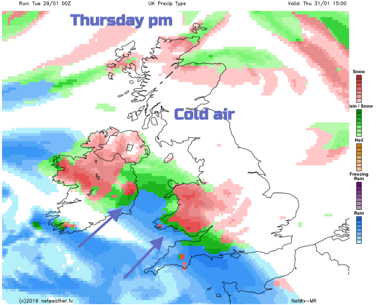
There may continue to be the odd coastal wintry shower into the evening, but most places should continue dry after dark. Clear spells and light winds will lead to another widespread moderate frost in places and some freezing mist or fog patches again, as temperatures away from coastal areas fall to between -2 and -5C. Later in the night a freshening East or South Easterly wind across South Wales and the South West will be bringing increasing cloud and probably some rain by dawn. As this spreads North and East on Thursday it'll readily turn to snow no doubt prompting more warnings of possible disruptive weather to come, but it's northward extent is uncertain at the moment. So stay tuned!
More chat on the Netweather Forum