The end of January looks like bringing snow to the UK. WIntry showers from the west but also a band of snow reaching SE Britain is possible later Tuesday. More elsewhere as the week progresses.
You’ll be hearing a lot about #UKSnow this week, (which isn’t the same as actually seeing lots, you might) but it could be a welcome change from Brexit. The Met Office has issued a Yellow warning for snow across SE Britain Tuesday night into Wednesday “possibly heavy”. There is also the likelihood of more widespread snow on Thursday as an Atlantic front arrives against the cold Arctic air from the SW.
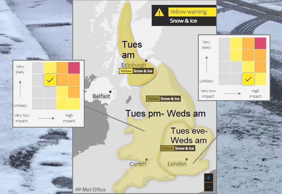
"A band of rain pushing east across parts of England is likely to turn to snow during Tuesday evening, with snow continuing into Wednesday. Accumulations of 1-3 cm are likely quite widely, with accumulations of 5 cm in places. There is a small chance that some areas could see up to 10 cm, more especially over the higher ground." Met Office
This warning was issued on Sunday as a heads up, a watch for the days ahead. There is a lot of uncertainty with it, not just the whole rain turning to snow bit, which will disappoint some. Looking at the matrix which accompanies the warning, in the further details section, you can see that the likelihood was deemed low in Sunday's forecast, but if it does come there would be high impacts.
There were signs on some models that a deep area of low pressure would run near to southern Britain, hitting the cold air during Tuesday night and might bring significant snow. This morning that developing low shows up as becoming quite a storm in the Bay of Biscay on Tuesday, maybe not skirting southern England so much. Lines of showers run in from the west during Tuesday bringing wintry showers and a cold front engages with the low to the south and this could bring snow too. The snow warning relates to the rear-edge of this frontal band, the cold front.
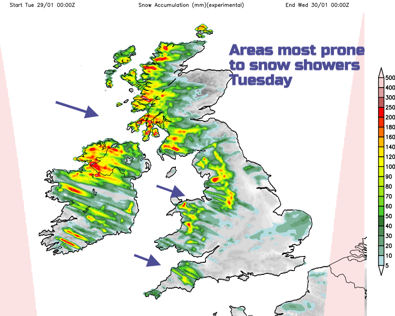
Snow could fall over southern Scotland and NW England Tuesday lunchtime, into Wales and more of northern England Tuesday afternoon then heading over more of England later on Tuesday away from Kent around midnight. It's a frontal band of rain, perhaps turning to snow as much colder air tucks in behind.
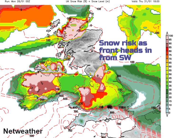
That's not eh end of this week's snow. More could follow, later Wednesday in the south and across more of the UK and Ireland on Thursday and Friday, although the position and timings have some uncertainty. The end of January looks like delivering the winter goods.
Today
It is chilly this morning, with ice to watch out for. Several degrees below freezing for northern England, Northern Ireland and Scotland with other inland parts of Britain just dipping below zero too with a frost. However, it’s not as windy as it was yesterday. The strong north wind has eased down so it doesn’t feel as cold.
Today for much of Britain it will be a fair bright day with light winds. There will be showers for northern Scotland and a few clipping East Anglia and Wales as more of a NW wind keeps going around some coasts. These showers will include snow for northern Scotland and could be wintry for eastern England. Top tempeatrues around 4 to 6C, up to 8C in the southwest. Through the afternoon an occluding front topples over Northern Ireland with brisk west winds, more cloud and rain, which reaches western Scotland and Cornwall. This frontal band will turn to snow over Highland Scotland later today.
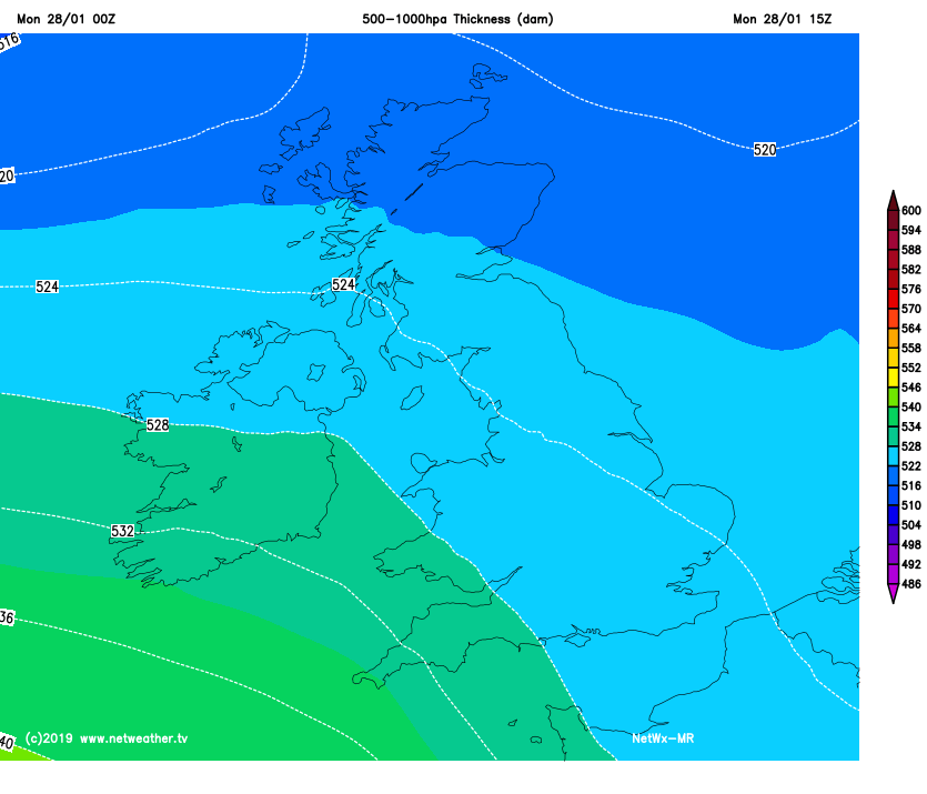
Then a proper cold front heads in from the NW and behind this will be much colder air for the UK. This was one ingredient in the snow making setup. The low to the south seems to be missing the south coast but there will still be plenty of sleet and snow showers coming in from the west through Tuesday and Wednesday. And then the cold front allows the real cold air to flow in and snow should appear after the rain.
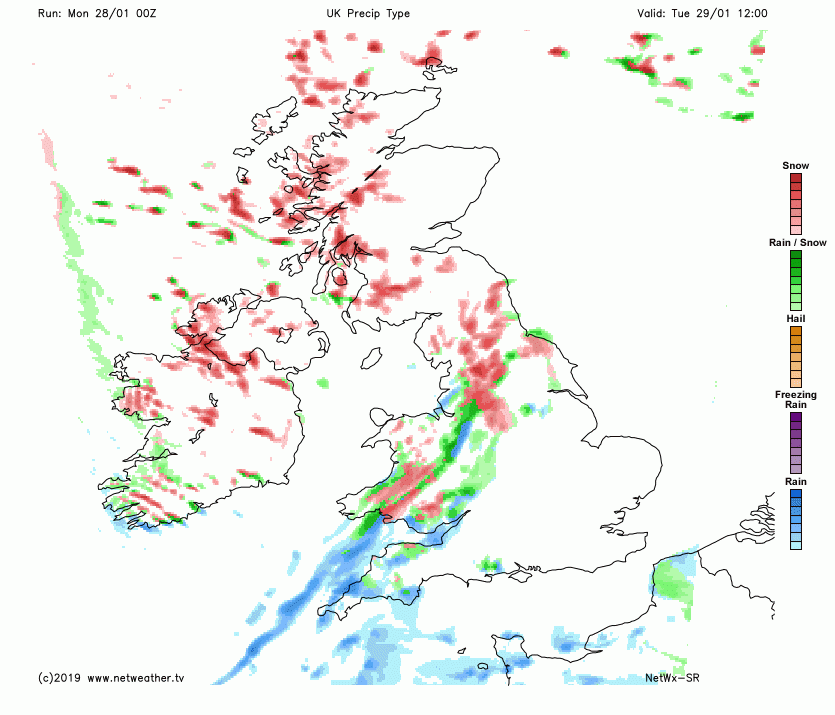
This means there would be lying snow for Wednesday morning. Don’t take the yellow warning area too literally. Just because you are in it doesn’t mean you will definitely get a few cms of snow. Just because you are just a bit outside the area, doesn’t exclude you from snow. Look at the overall sweep of this front and keep in mind that there could be wintry weather or even significant snow to contend with.