Many have been dry since before Christmas, but a band of rain spreads southeast today, followed by colder conditions rest of the week and through the weekend. Risk of frost and snow in places.
For many, it hasn’t rained properly since before Christmas, thanks to high pressure in control for the last three to four weeks. However, today will see outbreaks of rain affect all areas. Following today’s rain, it will turn increasingly colder from the north tonight, with showers across north and west turning increasingly to sleet and snow, these wintry showers becoming confined to eastern coasts on Thursday, otherwise a sunny but colder day than recently. Friday and the weekend will remain cold with a risk of overnight frost where skies clear, mostly dry and bright in the east but a band of rain slowly moving into the west on Friday and Saturday, turning to sleet and hill snow. Otherwise mostly dry.
After recent mild weather, turning colder from tonight and staying cold through the weekend.
For now, many areas are starting the day cloudy and mild with a band of rain stretching southwest from northern England down across Wales, some patchy drizzle further south and east across England, while Scotland is seeing showers spread in from the northwest, turning increasingly to snow over tops of the hills and lower levels in the far northwest as colder air moves in here.
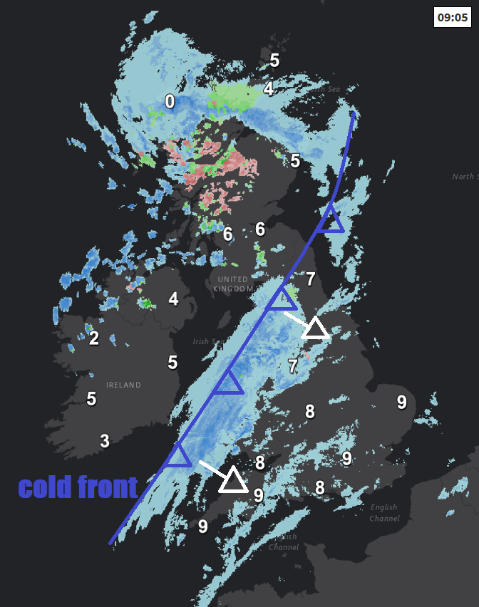
The band of rain along a cold front across northern England and Wales will slowly edge southeast across England through the day, bringing a couple of hours of rain, patchy drizzle ahead of the rain band. Rain band perhaps not reaching SE England and East Anglia until late afternoon. Following the rain will be brighter but showery conditions spreading in from the northwest, most of the showers across Scotland, N. Ireland and western coastal areas of England and Wales, turning increasingly wintry in the far north and northwest as colder air moves in, falling as snow over higher ground.
Generally mild across England and Wales today, highs of 9-10C. Temperatures falling away through the day across Scotland and N. Ireland – as colder air kicks in here from the north, afternoon highs of 5-7C here.
Cold front clearing the southeast this evening, taking the cloud, rain and milder air away with it, then colder and clearer conditions for many leading to widespread frost in rural areas with a risk of ice on untreated wet surfaces. However, there will also be some wintry showers pushing southeast, mainly across Scotland, northern England, Wales and the Midlands, snow initially over hills but perhaps increasingly falling to lower levels by the end of the night.
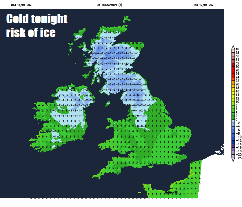
A cold but bright start to Thursday, with a rural frost and risk of icy patches, a strong northerly wind, scattered wintry showers at first across many parts, don’t be surprised to see some snow falling in some of the heavier showers at lower levels, perhaps a covering of snow over northern and western hills. The wintry showers will become increasingly confined to eastern coastal areas but also down across Wales and SW England too, mostly rain along coasts but inland a wintry mix with snow over hills. Central spine of the UK mostly dry and sunny but cold. Temperatures reaching 4-5C at best, perhaps 6-7C across the far west.
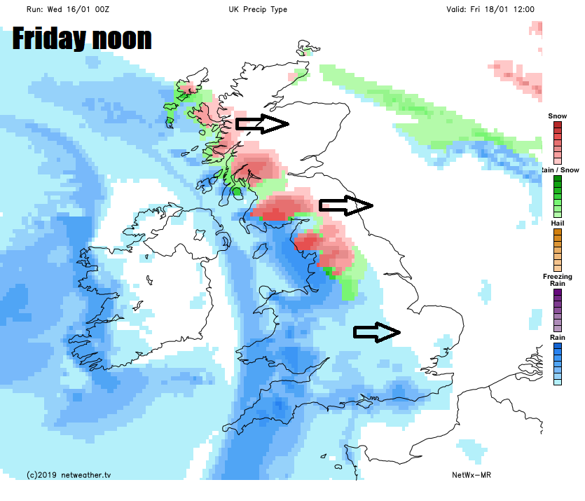
A cold and frosty Thursday night, then Friday another cold day, staying dry and bright across eastern areas, but cloud will thicken across the west, heralding outbreaks of rain moving in off the Atlantic across the island of Ireland first thing, then western Scotland, NW England Wales and SW England by lunchtime, turning to snow for a time inland as the rain bumps into the cold air. The rain, sleet and snow perhaps making it across the eastern areas later in the day, but some uncertainty how far east. Temperatures reaching 3-6C at best generally, less cold air arriving in far west with rain, where 7-8C more likely.
Generally cloudy across England and Wales to start Saturday, with patchy rain, sleet and snow across central, southern and western areas easing south through the day, perhaps drier and brighter across Scotland and N. Ireland. Another cold day.
Sunday’s looking mostly dry and bright across England and Wales after a frosty start, more in the way of cloud across Scotland, as an Atlantic front slides southeast, bringing a band of rain, sleet and snow.