Just because much colder for the second half of January does that mean we'll see snow? Worth getting Winter Ready whatever the outcome.
You might be feeling bombarded with extreme weather stories and not sure whether to believe any of it or are just quite worried that we are going to see a repeat of 2018 when the #BeastfromtheEast hit and was joined by #StormEmma in the SW. Last year saw a lengthy time of cold easterly winds, low temperatures, continual snow showers coming across the North Sea and major disruption for parts of the UK. All of which happened in March, quite late in the season really.
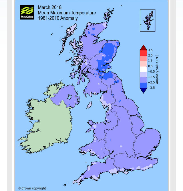
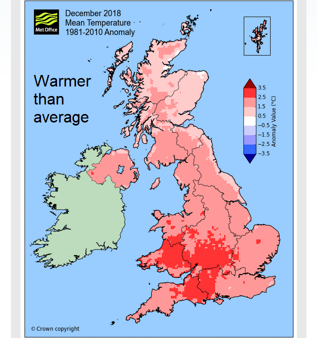
The signal for colder weather for the end of January is quite strong now. And potentially lasting well into February. This means that temperatures will be below average, so cold than usual for late Jan/Early Feb. So far this winter, it has been rather mild. December. January and February are taken as the three winter months in UK meteorology statistical terms, so last year really didn't fit well with the late cold March.
The Beast from the East is a process where very cold air churns its way from northern Europe and Siberia right across to the UK. This flow is anchored by a stable high pressure sitting over Scandinavia, the Scandi High. Everything is very steady and settled and so the cold flow just keeps on coming. It produces snow as the cold air moves over the North Sea, that sea track is important. In 2018, a low pressure snuck around this flow, up from France and produced extra precipitation and high winds, combining with the cold air to create extra mayhem.
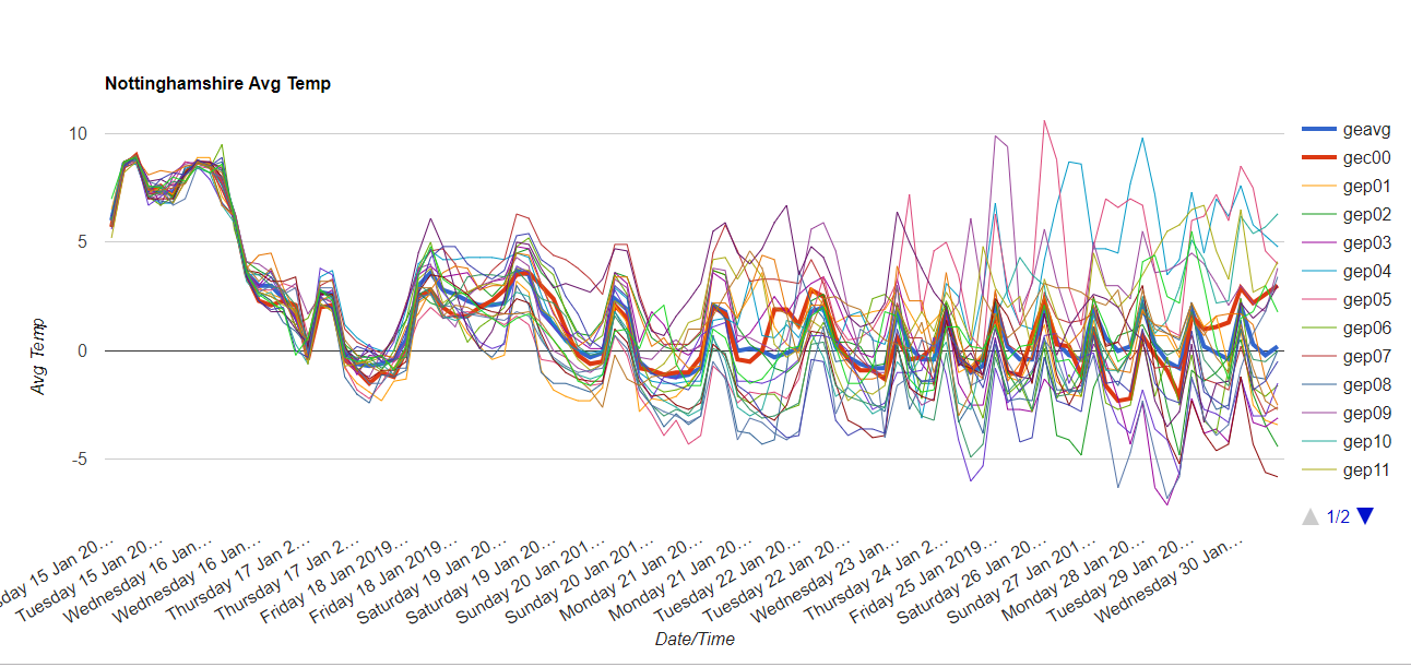
The trend to colder air this month. This winter, at the moment, that settling down and stability isn't showing. Things have happened up in the top part of our atmosphere, you may have heard mention of SSW Sudden Stratospheric Warming and the Polar Vortex, that can result in a cold winter. There is lots more in-depth chat on the Netweather Forum about these. Sometimes changes higher up in the atmosphere result in the usual flow west to east, reversing but not always. These changes are happening but there is still uncertainty about what will result.
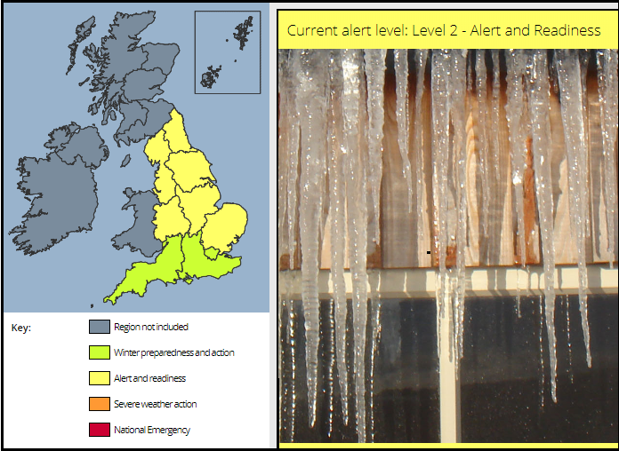
From UK Met Office and Public Health England Tues 15th Jan 2019
The government and health agencies are issuing messages about Winter Preparedness so that when the cold does take hold people have begun to get ready.
Is your heating okay, do you have de-icer for the car and the right screenwash mix. If like me you've just filled up with water from the garage on a journey, that does need sorting before temperatures start falling below zero, Check the lowest temp on the screenwash some are -4C some -23C. That people are watching the weather forecast and if they don't have enough medicine, it won't be needed on a snowy or icy day. Contingency plans if schools or nurseries are closed. 'It's a Snow day!' maybe joy for children, but a nightmare for working parents. Do you know what to do if a pipe is frozen or bursts? What if there is a power cut, it's not just the lack of Wi-Fi, it could interrupt heating, cooking and the lights.
When and where is snow likely?
This is about the cold in the first instance but also the possibility of snow and ice. As there isn't a steady settled picture it does mean that more parts of the UK could see snow, rather than just eastern Britain. However, it means that there is low confidence about where precipitation and strong winds will hit and arrive, never mind if they will be of rain/sleet or snow.
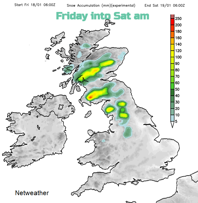
Wednesday 16th Jan there will be snow showers over Highland Scotland as the winds veer to the NW. 20cm over the tops of the Scottish mountains with flurries and a light covering over the highest hills of northern Britain and Northern Ireland as the showers whizz past. By Wednesday evening, there could be more wintry showers running down western Britain into NW England and over Wales and the snow showers keep on coming for northern Scotland.
Thursday has been standing out as this week's cold day and there will be a frosty start with ice and further sleet and snow flurries in the NW wind.
Next up is a low pressure coming in from the Atlantic, against that cold air. This is where the models being to diverge, the GFS showing snow over northern Britain as a frontal system moves in.
Other models such as the Met Office see the low being kept at bay by high pressure over Europe and a deeper low heading in for the start of next week. That could bring snow too.
If a true easterly does set in then snow showers will flood in from the North Sea once more and eastern Britain could get clobbered. Snow forecasting is tricky anyway and a shorter time frame is needed. Warnings will only be issued a day or so in advance, but it's worth thinking about the whole overall message. Turning colder with the possibility of snow and ice.
Will it Snow? five days ahead
Winter discussion in the Netweather forum