Mostly cloud but dry to end the week, then becoming windy and milder over the weekend, with rain in the north. Turning unsettled for all next week.
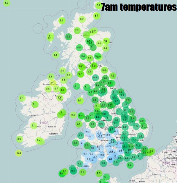
Thursday starts cold and frosty across the southern half of England and Wales, temperatures have fallen as low as -6.4C in Oxfordshire and -4C in Devon. But the frost is not as widespread as first thing yesterday morning, as it is cloudier further north across northern England, north Wales, N. Ireland and Scotland. The cloud across the north thick enough to bring some patchy light rain or drizzle in places, temperatures as high as 9-10C at 6am across the far north and northwest.
The cloudier skies and milder air across the north are thanks to a warm front, which will continue south through the day bringing cloudier skies and the odd spot of rain or drizzle south across England and Wales after the frosty start in the south. So into the afternoon most places will rather cloudy, though brightness may hang across the far southeast and some breaks may develop to allow some brightness across NE England, eastern Scotland and Irish Sea coasts.
Temperatures lowest today across the south, thanks to the cold start then cloud moving in, reaching 5-8C at best across much England and Wales away from the far west, across Scotland and the far west, reaching 8-10C.
Rather cloudy for most overnight, with a few patches of drizzle here and there, especially over hills, but many places staying dry and less cold than recent nights, thanks to a milder flow from the northwest off the Atlantic. Temperatures generally holding up around 4-6C, perhaps 7C in the far west, but with some clearer skies possible across northern England and eastern Scotland – we could see temperatures fall close to freezing here bringing a touch of frost.
Grey skies for many on Friday morning, with the odd patch of drizzle in the west, the one exception will be across NE England and parts of eastern Scotland – where it could be a bright start with a touch of frost. Generally extensive cloud affecting most areas for the rest of the day, low cloud over western hills bringing mist and drizzle. Best chance of some brightness along some eastern coasts of England and Scotland with shelter form the moist flow from the west. Temperatures reaching 7-9C widely.
Saturday looks to continues the cloudy theme but also becoming windy too, as low pressure system passing to the north of Scotland tightens isobars and brings weather fronts southeast across the UK, with rain across the north first thing clearing before further rain moves in across the northwest later. Central, southern and eastern areas mostly dry, with some brightness possible. Becoming mild, temperatures reaching 9-11C.
Sunday continuing in a similar vein to Saturday, with low pressure to the north and northeast bringing a brisk northwesterly flow with further sets of fronts bringing cloud to northern and western areas and further rain across the north, perhaps more in the way of brightness or sunshine across eastern areas though. Rather mild, temperatures widely reaching 10-12C.
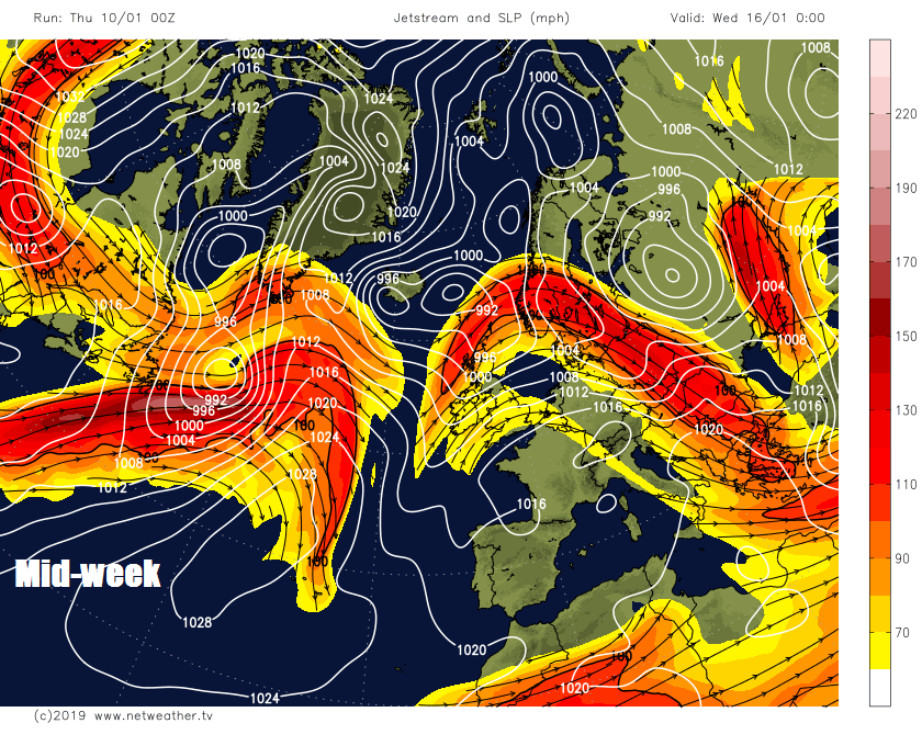
Becoming increasingly unsettled further south across all parts as we head through next week, as the high pressure that’s been close or over the UK the last few weeks retreats to the southwest, allowing Atlantic systems to roll in. Monday and Tuesday mostly dry and bright away from the far north and west, where there will be wetter and windier conditions. Spells of rain and strong winds spreading east across all parts from mid-week, interspersed with brighter, showery and colder conditions, showers turning wintry in the north, with hill snow, in the colder sectors moving through.
Jet stream returns next week, bringing in low pressure off the Atlantic with unsettled and windy conditions
Longer term prospects for the rest of the month, there are signs of a possible pattern change which could bring much colder weather later this month, more on this in latest blog below.