Wet & windy weather to start the weekend in the north, but generally settled if rather cloudy to see out 2018, with high pressure in control to begin January too.
In an otherwise benign pattern to see out the year and welcome in 2019, with high pressure in control, a blip tonight and early tomorrow for the north, as wet and windy conditions move east off the Atlantic, before brighter and drier conditions return by Saturday afternoon. Otherwise, a mostly dry weekend, cloudy across the south tomorrow and many parts on Sunday, but all areas mild. High pressure across the south early week will tend to build north, so a generally dry and settled picture for most through next week, turning colder across the south through the week, as a colder feed from the near continent develops here.
For now, it’s a cloudy and murky start but chilly start across central and southern areas of England and Wales, with mist and some dense fog patches across southern most counties of England to watch out for and a frost locally across SW England where skies have cleared. Further north, a mostly dry picture, with some brightness in places until reaching Scotland where it’s cloudy with some outbreaks of rain spreading east.
The rain across Scotland will tend to clear south and east through the morning to allow brighter skies and drier but breezy conditions to move in from the west for the afternoon, though perhaps remaining dull in the northwest, brightening up across Northern Ireland too by late morning. A band of cloud and patchy light rain or drizzle moving down across northern England and Wales this morning and into the afternoon, though rain tending to fizzle out.
A rather cloudy day ahead of this across central, southern and eastern England, though some breaks could allow some brightness or sunny spells – especially towards eastern England. Fog patches across southern England could be slow to clear, which will tend to keep temperatures in single figures, but generally a mild day after a chilly start across the far south, temperatures reaching 9-10C widely, perhaps 11C in the far west.
.png)
Into the evening and overnight, not a great deal of change in the south, rather a lot of cloud and murk around across England and Wales, with drizzle over western hills and fog patches developing in the south and east, turning chilly where skies clear towards the east too. Clearer skies across Scotland to begin with, before an area of low pressure brings wet and windy weather quickly east across Scotland and N. Ireland during the second half of the night. The rain reaching far north of England by the end of the night.
Wet and windy conditions spreading east across the north early hours and clearing Saturday morning
A wet and blustery start across the north tomorrow, but early rain quickly clearing much of southern and central Scotland through the morning, though showery rain lingering across northern Scotland. Thicker cloud and a band of rain moving down across England and Wales through the morning, drier and clearer conditions following across northern England and north Wales in the afternoon, staying rather cloudy further south, with patchy rain or drizzle across the west. Another mild day for the time of year, temperatures widely into double digits away from the far north, reaching 10-13C.
Temperatures above average for the time of year over the weekend
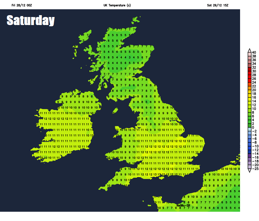
Sunday a less windy day for the north but still breezy. Most places staying dry, but generally rather cloudy, some patchy rain affecting western areas of Scotland and northern England for a time, best chance for some brightness or sunshine towards the east. Mild again, temperatures widely reaching 11-13C.
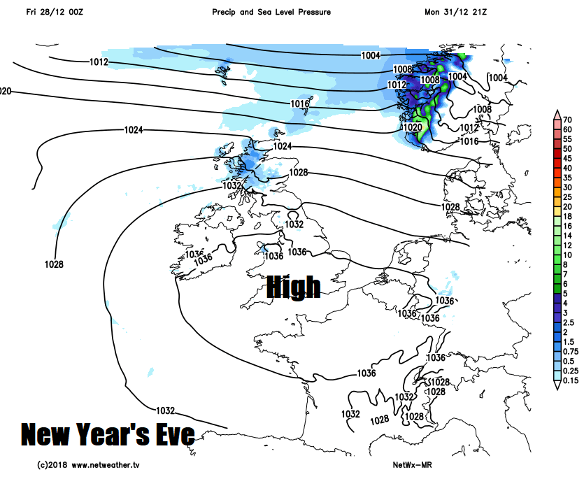
New Year’s Eve sees high pressure close to the south, so most areas staying dry and mild but with rather cloudy conditions circulating around the high across the UK. A trailing Atlantic front could bring thicker cloud with some patchy rain to northern Scotland. New Year’s Day again rather dry, mild but rather cloudy.
High pressure across the south to start the week looks to build north towards the end of the week, so staying dry and settled for most, drier and colder continental feed Thursday and Friday will lower temperatures into single figures in the south, so turning chillier here towards the end of the week, the clearer skies here allowing overnight frost to develop too.