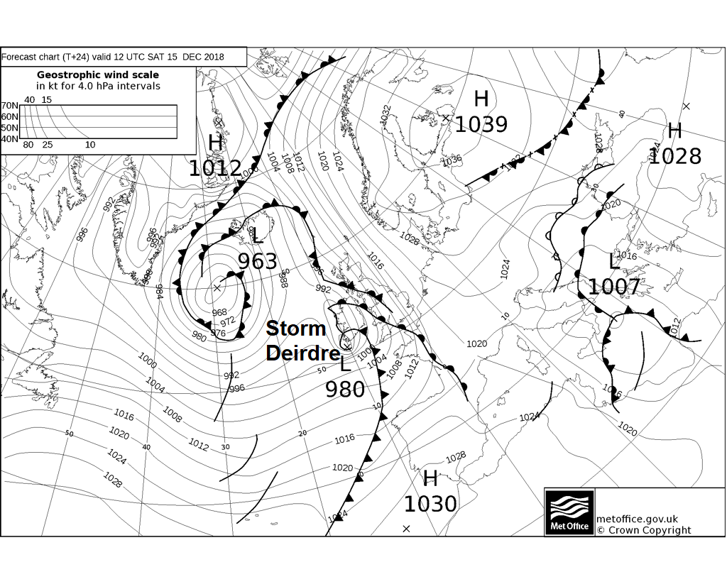
Storm Deirdre will bring winter hazards from the Midlands north later today, snow, blizzards and freezing rain could bring severe travel disruption. Gales and heavy rain also hazards elsewhere.
Storm Deirdre, named by Met Eireann last night, will bring severe wintry weather from the Midlands northwards today, with a disruptive mix of snow, gales, ice and freezing rain, with rain and strong winds affecting elsewhere. All of this on one of the busiest weekends of the year. Two Amber Warnings across northern England and Scotland were issued yesterday by the Met Office ahead of the storm being named, one for ice and one for snow, with a Yellow Warning for snow and ice across much of central and northern Britain. Other warnings are in place for wind and rain across SW England, N. Ireland and the Northern Isles too. So all-in-all, not a good day to be travelling, especially in the north, with a risk of freezing rain and heavy snow causing treacherous and potentially dangerous conditions in places later today.
For now, eastern Scotland and northern England, away from western coasts, are off to a clear but cold and locally frosty start, however it will be a rather different end to the day here. Cloud and outbreaks of snow are already moving in across parts of western Scotland and spreading across the central belt, while further south it is a cloudy and increasingly windy picture with outbreaks of rain, preceded by a little sleet or wet snow, are moving in across the island of Ireland, Wales and southern counties of England. Gales are developing across the west, gusting between 40-50mph around coasts, up to 60mph with exposure.
Outbreaks of rain across southern and western areas will intensify towards the west through the morning and into the afternoon, with locally up to 50mm falling by the end of the day across parts of SW England, Wales and Northern Ireland – this may lead to some flooding and treacherous driving conditions. Strong southerly winds will gust to 50-60mph locally, especially over hills and around coasts.

The rain, locally heavy, will progress northeastwards across many parts through the day, perhaps a little sleet or snow preceding it across southern and eastern England, but turning to snow and staying as snow through the afternoon and into the evening across inland parts of northern England and Scotland. The snow will turn increasingly heavy into the evening and with the strengthening south to southeasterly wind reaching gale force, blizzard conditions may develop, particularly over higher ground. 5-10cm are possible widely, locally up to 20cm and as much as 40cm over higher ground. This will likely cause travel disruption, with power supplies also affected by the combination of snow and strong winds.
There will also be the additional hazard of freezing rain developing this evening, most likely above 200-300m, as a layer of less cold air rides in aloft melting snow falling through it into rain – which falls toward the surface still around freezing – allowing widespread ice to form on all surfaces, causing tree branches to snap and power cables to fail.
Temperatures will struggle throughout the day across northern and eastern areas – reaching 2-3C at best, 0C over higher ground. Across southern and western areas temperatures recovering to around 6-7C, in the southwest reaching double figures.
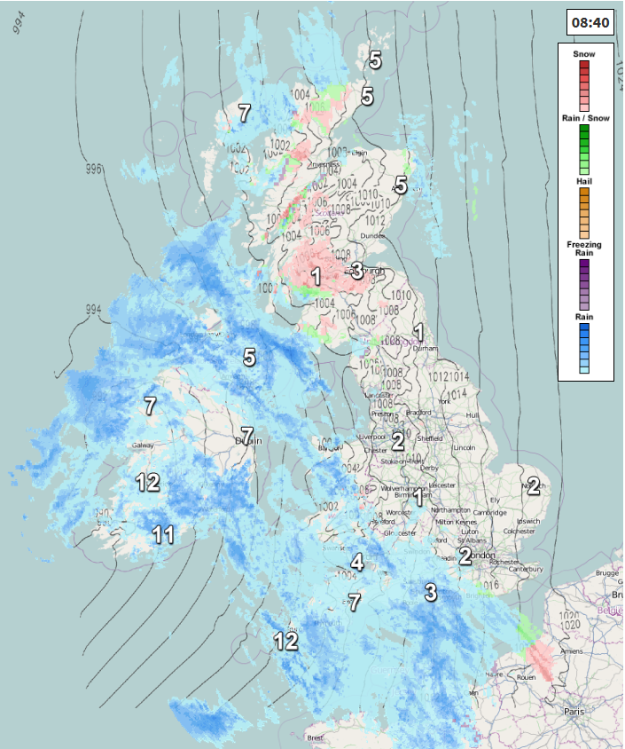
The snow across the north will turn to rain at lower levels through the evening, as less cold air moves in from the southwest, but there will continue to be a threat of freezing rain over higher ground bringing ice, while snow will likely continue to fall with blizzard conditions over higher ground of Scotland. Heavy rain should clear eastern England by midnight with winds easing a tad, rain, sleet and hill snow continuing for a time across the north overnight before eventually clearing all but eastern Scotland by dawn. Clear spells following from the west, but some heavy showers likely across the southwest.
Rain, sleet and snow clearing most places overnight to a calmer and brighter Sunday, though showers in the west will spread across the south
A calmer start to Sunday for many, with lighter winds, rain and hill snow clearing northeast Scotland first thing but most places seeing a dry and bright or sunny morning, but there will be heavy showers affecting the southwest and these will generally become more widespread across the west into the afternoon, while spreading east across southern and central England by the evening. Much of Scotland and eastern Scotland probably staying dry and sunny. A little bit milder, with temperatures 5-7C in the north, 7-10C in the south. Winds lighter in the east, but strengthening again in the west as the showers increase.
Milder still but becoming increasingly unsettled as we head through the new working week. Monday probably the driest day of the week, with most places dry and bright, though a few showers around western coasts. Wet and windy conditions arriving in the west after dark, before spreading east across all areas on Tuesday. Wednesday bright and breezy, but with showers around southern and western areas. Windy with more showers Thursday before more wet and windy weather sweeps through for Friday.