After a cold and mostly dry day today, wet and windy conditions for most on Saturday, but for Scotland and N. England there will be snow, ice and blizzard conditions developing.
Parts of northern Britain can expect some severe wintry weather tomorrow, with heavy rain and strong winds spreading from the west turning to heavy snow across northern Britain, falling to lower levels for a time, with blizzard conditions possible in the strong wind, which will bring the potential for travel disruption. But before then, Friday will be the calm before the storm, a sunny but cold day for most after a frosty start.
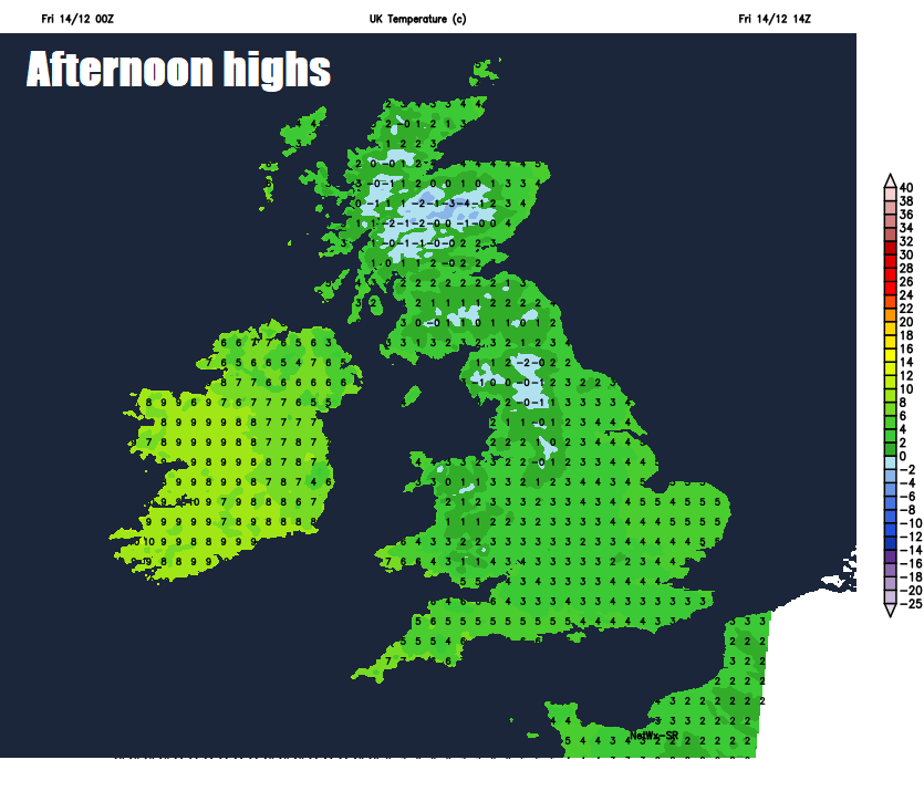
So, Friday dawns on a cold and frosty note for many, some of the coldest temperatures overnight have been across the south, with the temperature at south Farnborough in Hampshire falling to -6.7C.
There is more in the way of cloud towards eastern coastal areas this morning, bringing a few showers in the northeast and this will continue to be the theme through the day, with showers affecting eastern coastal fringes of England and Scotland. But for most it will be a dry and sunny but cold day, though the wind will less strong than yesterday. Cloud will thicken across the far west through the afternoon though, bringing outbreaks of rain accompanied by a strengthening southerly wind across the island of Ireland, the rain turning heavy through the evening. Temperatures reaching 3-5C at best for most, so a cold day, across the far west a little milder with 6-7C across far SW of England, west Wales and N. Ireland.
A few isolated showers across eastern coasts, otherwise quickly turning cold and frosty after dark under clear skies across central and eastern parts of Britain. In contrast across the west, wet and windy conditions spreading in from the west, rain turning to sleet and snow inland and especially over the hills for a time across Wales and western Scotland by the end of the night as it moves into the colder air.
Outbreaks of heavy rain accompanied by a strong south to southeasterly wind touching gale force will continue spread northeastwards on Saturday across northern, western and central areas through the morning, before reaching eastern England in the afternoon after a cold, frosty and bright morning here. With the cold air ahead of rain, some snow briefly for many preceding the rain, but unlikely to settle before turning quickly back to rain.
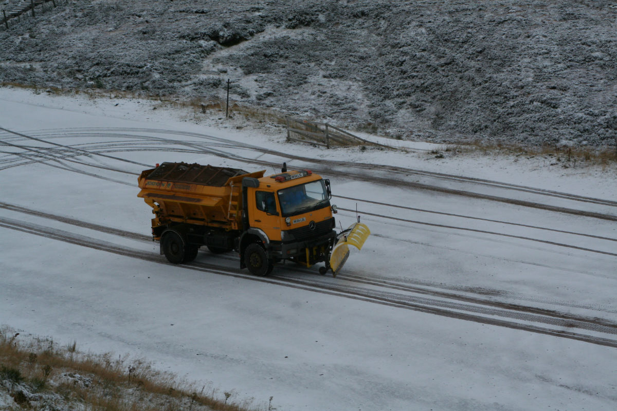
But across northern England and Scotland outbreaks of snow are more likely to persist through the day as the wet and windy weather bumps into the cold air last to leave here, the snow turning heavy by the evening, with a risk of freezing rain, particularly over higher ground, as less cold air spreads in from the west aloft initially above temperatures close to freezing at the surface, before snow turns to rain for most away from the Highlands by the end of the evening. A risk of disruption to travel and perhaps power supplies, particularly in the evening, as heavy snow, ice and blizzard conditions in the strong wind develop across the north. 2-5cm likely across parts of northern England by the evening, perhaps a much as 10-20cm possible across parts of Scotland.
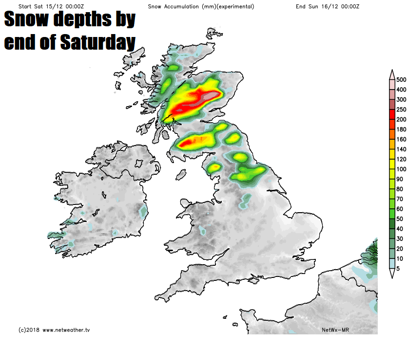
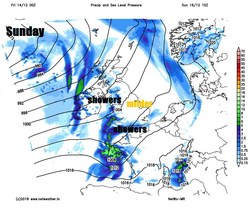
Overnight into Sunday, the snow across Scotland and northern England will mostly turn to rain at lower levels, but some heavy snow continuing over higher ground of Scotland, before rain, sleet and snow clears the north by the end of the night. Heavy rain across England and Wales Saturday evening clearing the east coast of England early Sunday and winds easing.
Sunday a brighter and milder but still breezy day for most, with sunshine and showers, showers mostly around southern and western coasts. Temperatures reaching 6C in Scotland to 10C across southern England.
Dry and sunny for many on Monday after a chilly start, though turning windy in the afternoon and eventually wet after dark across the west. A spell of wet and windy conditions spreading east across all parts Tuesday, then generally staying unsettled, often windy with further showers or longer spells of rain for the rest of the week and fairly mild too, more especially in the south.