Looking ahead at the rest of December, will there be any festive cold and snowy weather on the way?
December, on average, is nowhere near as cold as January or February, despite having the shortest day of the year. This is because surrounding seas have not reached their coldest – which affects the airmasses crossing it, seas tend to be coldest in early March, while continental landmasses can take a while to cool down too, though cool down much quicker than the seas.
Sometimes December weather can be unseasonably warm, such as recently in 2015, when exceptionally mild weather saw the temperature reach 17.2C in a few locations. Occasionally December can be very cold too, but more of an exception than the rule, with the month more like an extension of autumn. The Decembers of 2009 and 2010 are the most recent properly cold months overall, 2010 exceptionally so, the coldest since 1890. Both those winters saw a white Christmas in many places, in the sense of lying snow, though not perhaps falling snow. Despite the Charles Dickens inspired images from the Victorian era of snow-carpeted scenes on Christmas cards, TV adverts, etc – the Christmas period and indeed the big day itself is rarely white for most. The chances of a white Christmas are about 1 in 10 in the south of England, and up to 1 in 4 in the north. So, in reality, Christmas is statistically much more likely to be green than white
After a wet and windy week and generally mild, blustery and showery Saturday, the weather looks to settle down as we end the weekend and start the new week, as a ridge of high pressure builds north. Colder air will seep down across the UK from the northwest on Sunday, then early next week a ridge of high pressure will keep the weather settled, mostly dry and chilly by day with risk of frost and fog overnight.
Turning colder from the northwest on Sunday, then ridge of high pressure building north early next week
From mid-week there is growing uncertainty, with a fine balance between colder continental airmass trying to push in from the east and milder Atlantic airmass pushing in from the west. This battleground zone will likely be marked by a few Atlantic fronts erratically moving eastward on Wednesday and Thursday, with milder air to the west and colder to the east of the fronts.
00z ECM showing potential for snow to develop on Thursday evening, as Atlantic front moves in to colder air
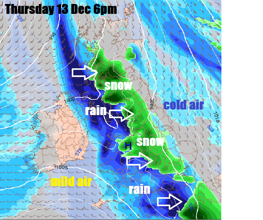
First front moving east Wednesday perhaps weakening with most rain fizzling out as it reaches the east, second on Thursday may have more oomph, with heavy rain perhaps turning to snow across northern, central and eastern areas as it bumps into colder air flowing from the southeast from a cold continental Europe ahead of the front. Evaporative cooling may play a big part in lowering the temperature to allow snow to fall too, given the surface airmass will be very marginal for snowfall. A potential low running across the south later on Friday could again bring some snow on its northern flank. So, an increasing chance some may see some snow later next week, perhaps significant locally, higher ground in the north most likely to see it, though can’t rule out elsewhere.
Perhaps a spell of milder Atlantic weather in the week before Christmas
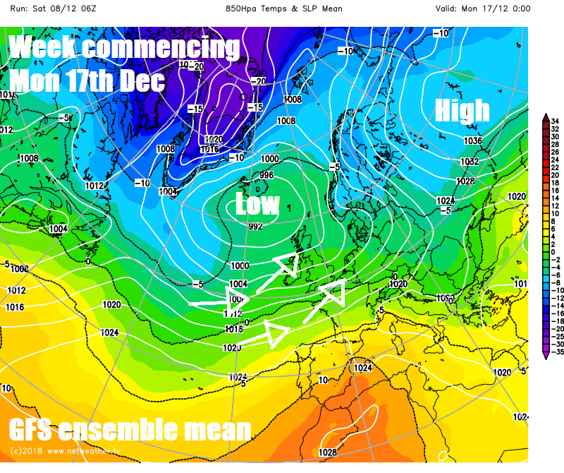
Thereafter, we may see a return to a spell of changeable, milder, sometimes wet and windy, weather off the Atlantic, as the blocking high over Scandinavia trying to push cold air west across the UK next week retreats. This unsettled and milder weather could last through the week before Christmas week (Mon 17th – Sun 23), but there are signs that this may be temporary before the upper flow buckles again, like the next few days, stopping the lows moving through off the Atlantic and perhaps allowing colder conditions to develop as we head into the weekend (22nd – 23rd) before Christmas.
Then into Christmas week (Mon 24th – Sun 30th) – it’s too far off to commit to forecasting a white Christmas, suffice to say there is a greater chance than normal for more settled and colder weather this week, with a small chance of snow, using recent longer range guidance – such as the twice weekly ECMWF model 500mb forecasts for 46 days (6 weeks) ahead, but just as likely is an Atlantic low pressure influence continuing and bringing a mild and green Christmas.
Longer term as we approach and head into the start of the New Year, the current moderate El Nino event over the tropical Pacific, which is expected to last through the winter, is expected to continue to have large background influence on the extra-tropical weather patterns downstream across N America, N Atlantic and Europe. The bursts of westerly momentum in the upper flow caused by El Nino and the related Madden-Julian Oscillation (MJO) wave propagation around the global tropics can cause poleward pulses of energy that create waves in the jet stream – which produce ridges and troughs, allowing blocking highs to form and subsequently a greater chance of colder conditions for the UK, if we get on the ‘right’ side of the block. These waves in the upper flow also propagate higher up towards the stratosphere, causing warning at high latitudes, which can impact the stratospheric Polar Vortex (SPV) by displacing it from its normal home over the North Pole.
If there are more than one of these planetary waves impacting the polar stratosphere, then we may see a sudden stratospheric warming (SSW), which can split the SPV and weaken it so much that stratosphere warms above the arctic and feeds down to troposphere creating prolonged high latitude blocking which causes cold air over the arctic to be pushed to lower latitudes of N America and Europe, bringing cold and snowy weather. Such an event occurred in late February this year and led to the ‘Beast From The East’ as marketed by the media when we saw bitterly cold easterly winds and snow in March.
We are also heading towards a solar sunspot actiivity minimum, the minimum predicted in the next year or so, which can also lead to an increased chance of cold and wintry spells in winter. The winters of 2009-10 and 2010-11 featured some notably cold and snow weather and were also during a solar minimum.
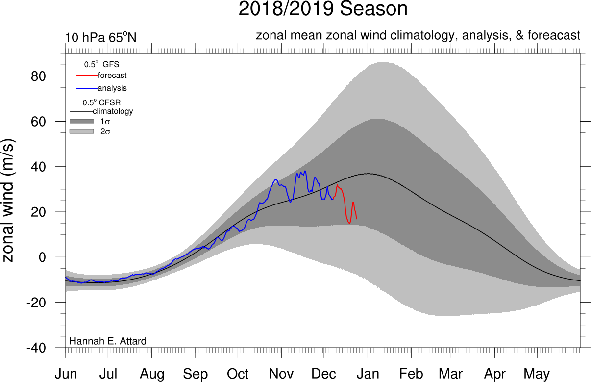
The American GFS weather model for a while now has been showing the zonal winds of the upper stratosphere declining rapidly towards the end of December, indicating a weakening of the polar vortex and warming in the stratosphere.
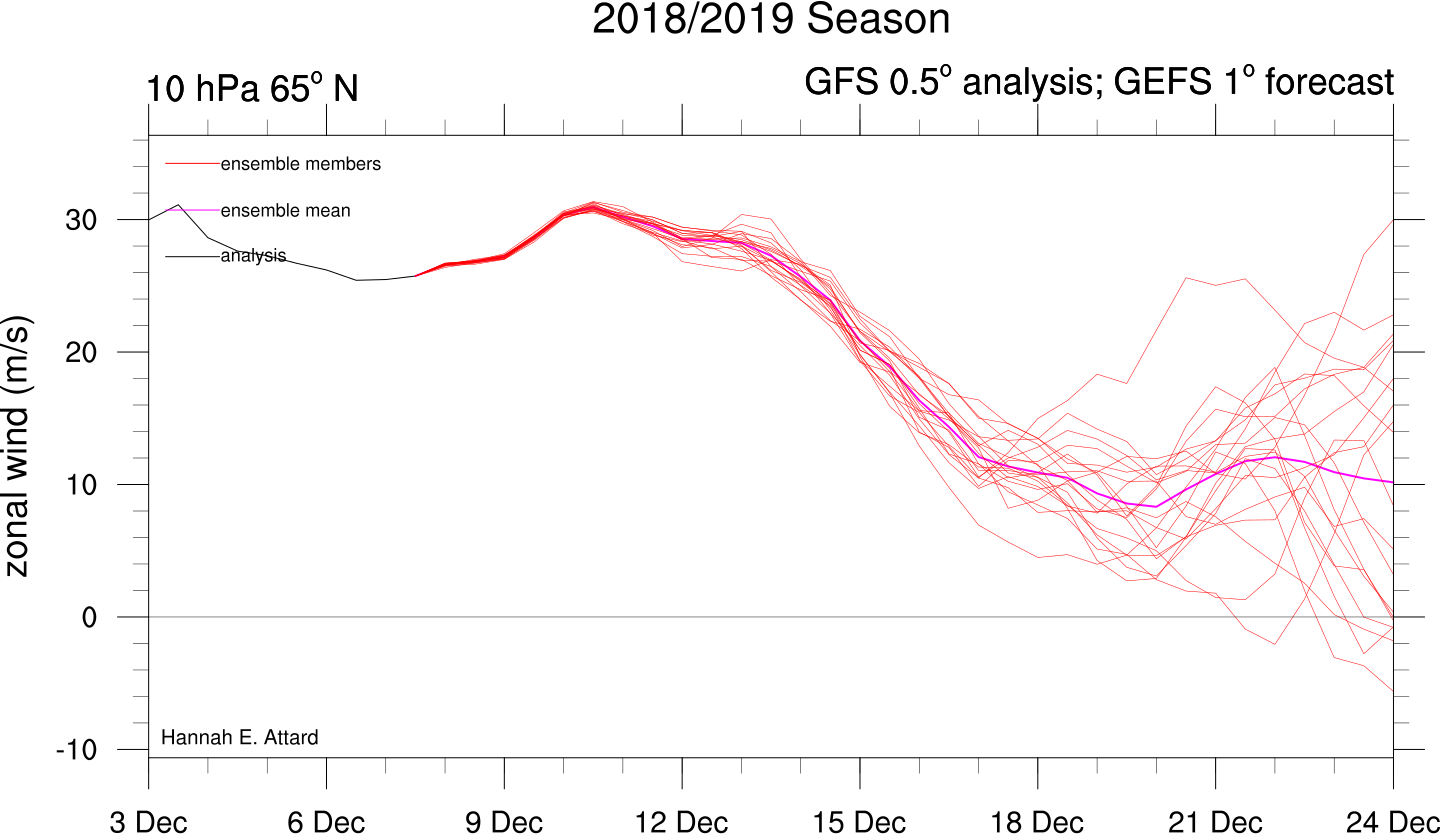
Some of the ensembles for 10 hPa wind, that’s near the top of the stratosphere, have shown a reversal of zonal stratosphere winds at this level, indicative of a SSW, but we would need to see more ensemble members heading this way to say it is likely. But there are strong signs we may see a SSW early in the New Year, increasing the risk of deep cold from the north, northeast or east arriving and plunging the UK into wintry weather. A SSW could occur as early as late December, but more likely the New Year.
So all-in-all, promising signals at the moment for those who want to see cold weather with a risk of snow, more particularly later this month and in January.