More wet and windy weather today and that theme will carry on into the weekend and next week too.
Another day, another spell of wind and rain moving through today. It's England and Wales seeing the strongest winds with gales, severe in places, pushing up from the southwest and across all parts before easing down during the second half of the day.
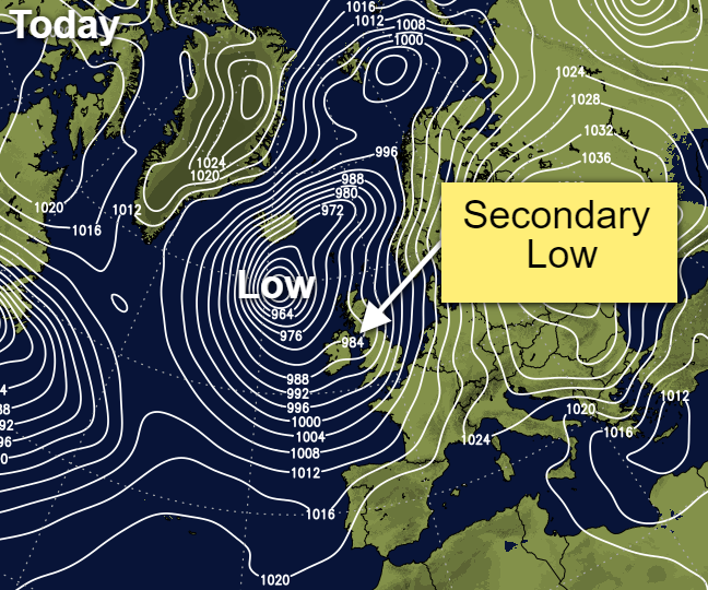
Accompanying the blustery winds is a spell of wet weather, moving northeast with some sharp, squally showers tucking in behind it. Those showers will continue to blow into the west, making it some way across the country through the remainder of the day and overnight. The culprit for all this: a small secondary low pressure system which has formed off the back of the main 'Storm Diana' low which is still out in the Atlantic.
Despite the wind and rain, it's another mild day today with highs generally of 8-12c, but peaking at 13-15c in the southeast and East Anglia.
Tonight, we keep the showers coming into the west and also the south. Some central and eastern parts will stay dry with some clear spells. But winds will be strong across Scotland in particular, with gales again likely in exposed places.
Into tomorrow, there'll be plenty of showers in the north and the west, some of which will be heavy and thundery. Further east, and particularly in the southeast, it should stay dry with plenty of sunny spells, so a respite from the wind of rain here. It'll be a cooler day than today, with highs of 4-7c across much of the country, but reaching 7-10c in southern and eastern England.
Through the evening and overnight, some showers will remain in the west, but elsewhere, with clearer skies, there could be a touch of frost here and there. Winds will increase, and rain will arrive from the southwest during the night though, as the next system turns up.
That means a wet, blustery start to the weekend, especially from the south of Scotland southward, with the heaviest rain across southern and central England. The northern half of Scotland should be drier with a scattering of showers, most particularly in the west. Behind the rain further south, it should clear up and dry out for most into the afternoon, with just a few showers left behind.
Sunday then delivers a virtual repeat performance, with another spell of wind and rain moving through similar areas overnight and first thing, before clearing to brighter or sunny spells and some showers. Later in the day, yet another system turns up, bringing more rain across Ireland first, before running across Britain later in the evening and overnight. That takes us into next week, and the unsettled weather will keep coming.