Crisp sunshine and showers over the weekend, risk of frost and icy patches overnight, showers wintry over hills in the north. Remember clocks go back tonight.
It will be a cold and frosty weekend for all, with sunny spells and showers and a brisk northerly wind. Showers will mostly affect northern, western and eastern coastal areas today, though some will penetrate central and southern areas too. Tomorrow will see showers become confined to eastern and southeastern England, a strong northeasterly breeze here, but with winds falling light and plenty of sunshine elsewhere. After a dry Monday, Tuesday looks to turn wet across the east, rain affecting southern areas on Wednesday, then turning unsettled, with rain at times, across all parts Thursday and Friday.
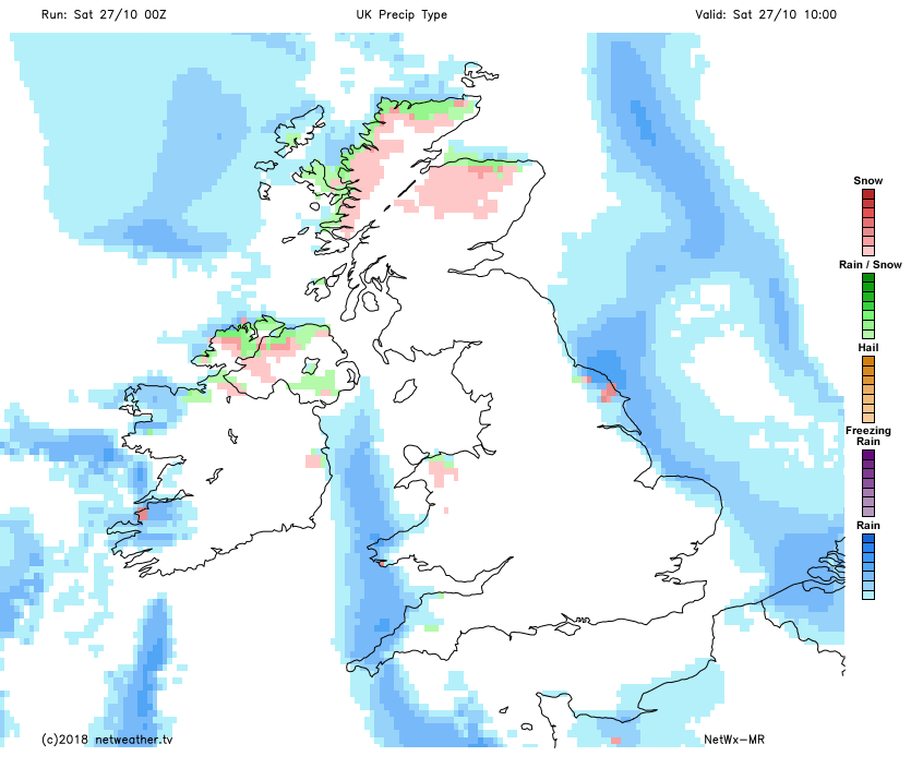
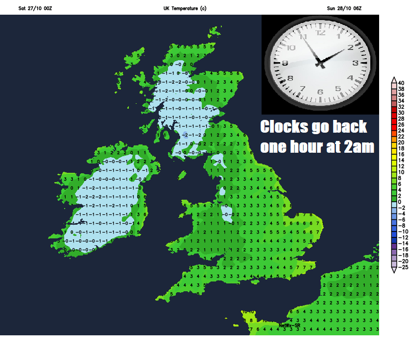
There is a risk of some slippery surfaces first thing this morning, particularly where we have seen showers continuing through the night across Northern Ireland, northern, western and eastern coastal areas – where temperatures have fallen close to freezing overnight. Also, snow settled from showers over higher ground of Scotland, with some significant falls affecting some of the higher routes of the Highlands and Grampians. Elsewhere, clear skies have allowed temperatures to fall widely close to freezing overnight, some central spots one or two degrees below freezing at dawn.
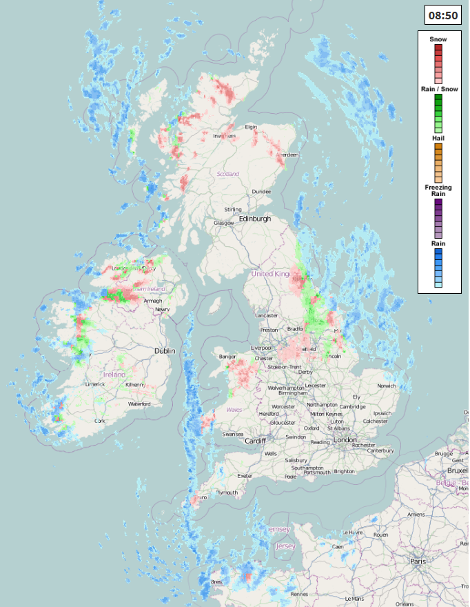
For today, there will plenty of sunshine across many areas away from northern, western and eastern coastal areas exposed to the brisk or strong northerly wind – which will feed in further showers throughout the day, heavy at times, with a risk of hail, thunder and falling as sleet and snow over higher ground in the north. Some showers, locally heavy with hail, will get inland across central and southern areas of England, particularly this afternoon, but generally this morning staying dry and sunny here. A cold day for all, temperatures not getting any higher than 6-8C for most, the wind chill from the northerly wind making it feel more like 1-4C.
Any showers across central and southern areas generally clearing in the evening, but continuing through the night across eastern and southeastern England and perhaps coasts of eastern Scotland. Elsewhere, clearing skies will allow for a frost to develop as winds fall light across northern and western areas, temperatures falling to -1 to -2C, perhaps as low as -4C in some prone frost hollows. A brisk northeasterly wind and showers towards eastern England generally keeping temperatures above freezing. Remember, the clocks go back an hour early in the morning, so an extra hour in bed!
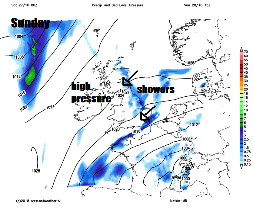
High pressure builds in from the west for Sunday, so winds will fall light away from eastern and southeastern England – where we will keep a brisk northeasterly wind – which will continue to blow in further showers from the North Sea through the day, a few showers possible for eastern coasts of Scotland too. Otherwise, after a frosty start, most places will be dry with plenty of sunshine, particularly across northern and western areas. Less cold than today, but still on the chilly side, temperatures reaching 7-9C at best. Getting darker earlier in the evening, because of the clocks going back an hour.
Further showers for eastern coastal areas on Monday – driven in by an easterly breeze, otherwise after a frosty start most places dry with sunny spells and light winds. On Tuesday, low pressure over the near continent looks to edge northwest across the North Sea, spreading outbreaks of rain across eastern areas of England through the day, turning cloudier from the east through the day across the north and west, though some brightness lingering across the far north and west.
On Wednesday, rain clipping far NE of Scotland, otherwise a mostly dry and bright start, before showery rain spreads in across southern areas, as low pressure this time moves in from the southwest. Generally unsettled and breezy Thursday and Friday, with spells of rain spreading northeast across most areas.