


This week looks quieter, although starting off wet for some. It will still be warm in the SE but there is already a bit of a nip in the air and frosts will appear later this week.
This week looks quieter and cooler than the last. For the flood hit areas after Storm Callum this will be welcome relief with a few flood warnings still in place. Not only was there heavy and persistent rain, there were gales and very warm air drawn up from the south giving weekend temperatures over 26C on Saturday and 21C on Sunday.
We could see the low 20sC in East Anglia on Tuesday, a frost early Thursday for northern Britain and Ireland and on Thursday night then feeling warmer by Saturday
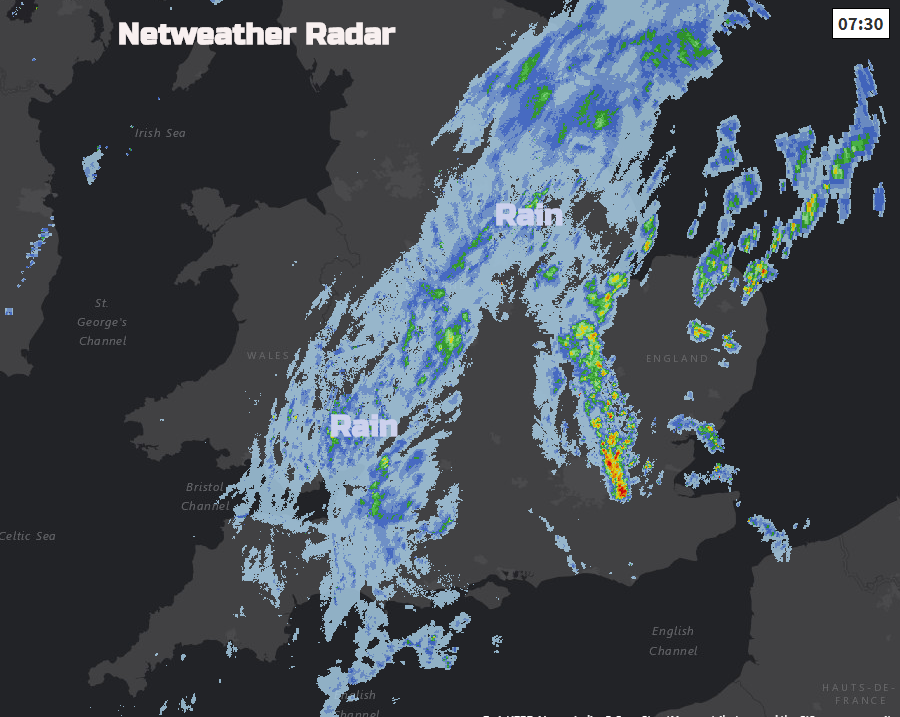
A trailing weather front is still bringing rain over parts of England this morning and SE Wales. A deep area of low pressure will miss the UK by veering off towards Iberia today. It’s fading but still, unwelcome extra rain after Hurricane Leslie got so close on Saturday.
After a total of 70 advisories, long-lived Leslie has become post-tropical just west of the coast of Portugal, finally succumbing to the combination of cool waters, strong vertical wind shear, and interaction with an approaching cold front. NHC Sat 13th Oct
Nowhere near as windy here this week. The Western Isles will experience some strong winds as frontal bands run past but nothing major. These frontal bands fade across the UK with spells of patchy rain but the weather will become more settled by Thursday as pressure rises, and it turns cooler.
Today
It’s a colder start this morning with temperatures below freezing last night for Cumbria, Northumberland and parts of Scotland. There are mainly clear skies and sunshine, with just a scattering of showers over the far NW of Scotland. Here a fine day but cool around 11 to 13C with light winds.
For much of England and Wales, there will be more cloud and rain for some. Along the frontal band, there will be a NE wind, which will make it feel cool for Lincolnshire and East Yorkshire with more rain. There will be brighter skies for northern England and north & west Wales. To the southeast of the front, there will be drier weather, even some bright skies and temperatures will be up to 18 or 19C for Kent or Essex.
The rain becomes very light and patchy by the evening with a lot of cloud about overnight. Kent may still have some clearer skies and it remains cool further north with patchy medium level cloud.
Tomorrow
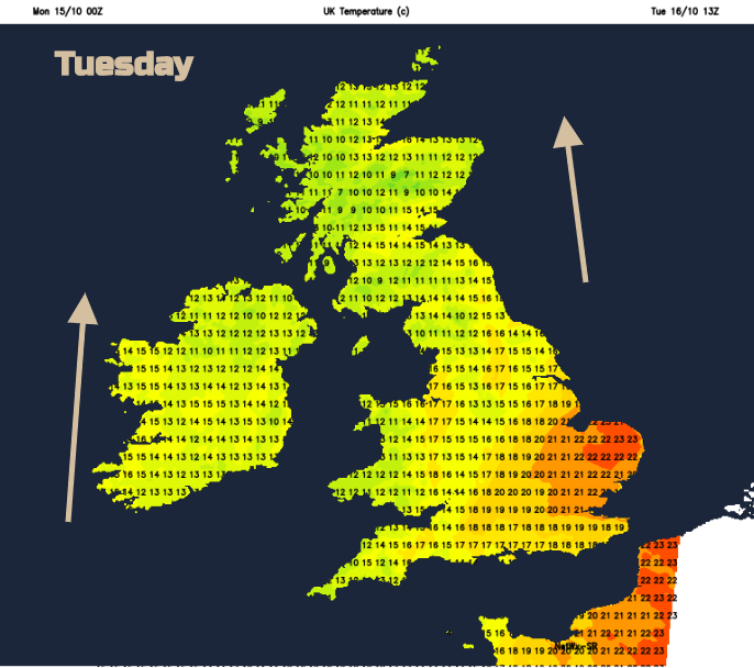
By Tuesday morning there will be a lot of cloud over the UK and a new weather front edging wind and rain into the far NW. Brighter breaks or sunny spells will appear, but it will be East Anglia seeing the highest temperatures in a brisk southerly wind.
A look back at Storm Callum


