Further heavy and persistent rain for northern and western areas today, dry, sunny and very warm in the east. Sunday rain in the east, becoming dry and bright in the west.
Storm Callum brought a windy Friday for many, particularly windy and wet across the west. Wales bearing the brunt of strong winds and rain, gusts of 86mph recorded at Capel Curig and 74 mph at Aberaron, while in the south Libanus in Powys has seen over 170mm of rain since early yesterday. The large rainfall totals across falling across the hills of south Wales related to 28 flood warning now in force here. Not only is Storm Callum notable for the rainfall it’s brought to the west, Met Office analysed the central pressure of 938mb early on Friday, making it the deepest extratropical Atlantic storm since at least 1979 for this early in the season.
The trailing weather front from Callum, now way to the north, extends across northern and western Britain and all the way south to Hurricane Leslie, currently drifting northeast between the Azores and Canary Islands towards Iberia. The ‘tug of war’ between these two storms along this frontal boundary separating warm and humid tropical air to the east and cooler polar air to the west means the front will not move very far today, bringing further heavy and persistent rain across the west today. To the east in the warm air being pulled up from way to the south, we could see 25-26C today, which may beat the October temperature date record. The front will finally move on east on Sunday, bringing a wet day to southern and eastern England, while cooler but drier conditions move in across the north and west.

So northern and western areas of Britain will see further persistent and heavy rain today spreading northeast along the slow-moving frontal boundary. The Met Office have an Amber Warning for rain still in effect until this evening for south Wales – where the rain will continue to pile up. There are also Yellow rain warnings in place for the rest of Wales and large parts of northern England and Southern Scotland. Wales, Cumbria and SW Scotland may see another 3 or 4 inches today, increasing further the risk of flooding in these areas. Northern Scotland is dry and bright for now, but rain will arrive and set in here later too. Windy across the west, gales up through the Irish Sea and coasts of Wales and SW England.
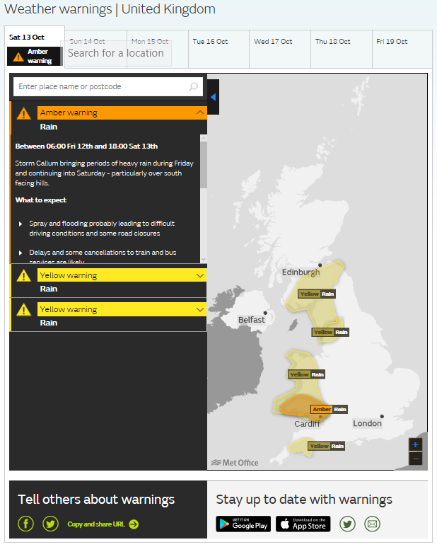
Met Office Yellow & Amber Warnings
Flood Watches & Warnings for Wales
Flood Watches & Warnings for England
Flood Watches & Warnings for Scotland
Across southern, central and eastern England, after an exceptionally mild night for the time of year, already 20C in eastern England at 8am, some heavy showers may affect southern and central parts for a time this morning. But generally here today it will be dry, bright or sunny and becoming very warm, perhaps recording-breaking warmth, with temperatures reaching 22-25C, perhaps 26C. Windy, perhaps touching gale force along southern coasts.
The rain should ease across the west this evening for at time, as it clears away eastwards, reaching eastern England as a narrowing band of rain in the early hours. Though persistent rain likely to linger across northern Scotland. However, further pulses of heavy rain will spread up from the southwest across parts of Wales and southwest England by the end of the night.
The north of Scotland, Wales and southwest England off to a wet start on Sunday, elsewhere a dry and bright start. The rain will clear east from Wales and SW England to affect the Midlands, southeast England and East Anglia by the end of the morning, before clearing here in the afternoon, though may linger across Kent, East Sussex and coastal East Anglia. Elsewhere mostly dry and sunny, rain clearing northern Scotland in the morning replaced by blustery showers across northwest Scotland. Feeling cooler everywhere, notably so in the east, temperatures reaching 10-13C in the north and west, 14-17C in the south and east.
Monday’s looking generally dry and bright with light winds, perhaps a few showers affecting the far northwest. Wet and windy weather spreading east on Tuesday, though the southeast may stay dry until dark, gales across north and west. Bright, breezy and cool on Wednesday, showers in the west. Thursday for now looking mostly dry and bright, cloud and rain moving in across Scotland and N. Ireland by evening. Cloudy and breezy with patchy rain in places on Friday, though southeast may stay dry.