Storm Callum will bring severe gales to Ireland and NW Britain overnight, then heavy and persistent rain will affect the north and west Friday and Saturday
The latest hurricane to hit the U.S. made landfall across the northeast Gulf of Mexico coast in the Florida Panhandle yesterday as a category 4 hurricane with winds as high as 155 mph, causing widespread devastation across that part of Florida and adjacent parts of Alabama and Georgia. #Michael has now weakened to a tropical storm, as it continues to track northeast over Georgia, with maximum sustained winds down to 60mph. The storm is still expected to bring heavy rainfall and flash flooding as it continues to move northeast across the mid-Atlantic states of the U.S.
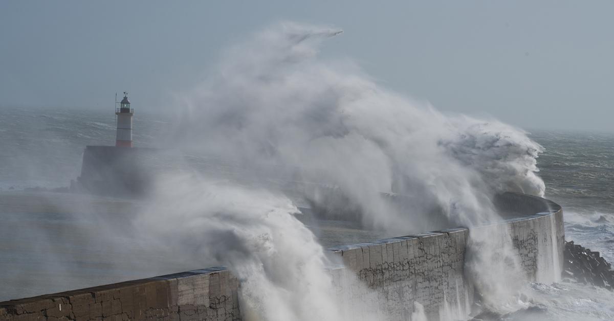
Closer to home, although not quite as threatening, there will be a deepening depression, named #StormCallum by Met Eireann, moving northeast to the west of Ireland tonight and to the west of Scotland on Friday. The strongest winds from Callum will be across western Ireland – where gusts of 60-80mph are likely, however severe gales are also likely across the northwest for a time and later developing up through the Irish Sea on Friday to affect western areas of Britain, with gusts of 60-70mph possible for a time.
Yesterday saw blue skies across most of the UK and, with a southerly flow, temperatures soared in the sunshine into the low twenties, the highest official temperature of 24.6C at Northolt in northwest London, making it the warmest October day for 7 years. Still warm today, but not quite as warm or sunny as yesterday, as it will turn more unsettled and windy, as spells of rain spread from the west across most parts by the evening.
The warm and moist southeasterly flow is bringing some fog across northern and western hills to start the morning, while there are some showers affecting SW Scotland, northern and eastern England moving north. Otherwise, it’s been a dry and bright start to the morning across many areas, very mild too, with temperatures in the low to mid-teens at dawn.
Showers will continue to move north across Scotland this morning, clearing northern and eastern England to leave much of England and eventually eastern Scotland largely dry with some warm sunshine this morning and into the afternoon. However, further west, a band of showery rain already across Ireland and arriving over SW England, will spread in across western areas through the day, heavy and persistent in places and accompanied by a strong southerly wind.
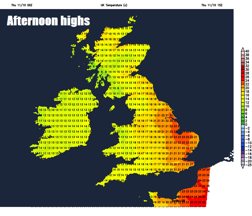
Temperatures towards eastern England reaching 20-21C this afternoon in the sunshine, 16-18C across Scotland, northern England, Midlands and east Wales, turning cooler in the far west as the rain clears Northern Ireland, west Wales and far southwest of England this afternoon.
Through this evening, a band of intense squally downpours will continue east across Scotland and England, accompanied by strong wind gusts and perhaps an odd rumble of thunder. The rain clearing Wales and SW England to leave a dry and clearer end to the day then areas further east later into the evening. Clearing for most after midnight as the evening rain clears away east, before further heavy rain quickly spreads northeast across Ireland ahead of Storm Callum and eventually the far west of mainland UK in the early hours, accompanied by a strong to gale force southerly wind, severe gales across western Ireland.
Friday will be a windy day wherever you are, but particularly so across the west, as Storm Callum tracks northeast to the west of Ireland and eventually Scotland. The northwest of Britain will bear the brunt of the strong winds in the morning, where gusts of 50-60mph are likely, perhaps up to 70-80 mph over exposed coasts and hills, even stronger winds over western Ireland – where we could see 70-80mph gusts. As well as potential disruption and possible tree damage from the high winds, with high tides peaking in height, there is a risk of coastal flooding across the northwest too.
Met Office Yellow Warnings for rain and wind
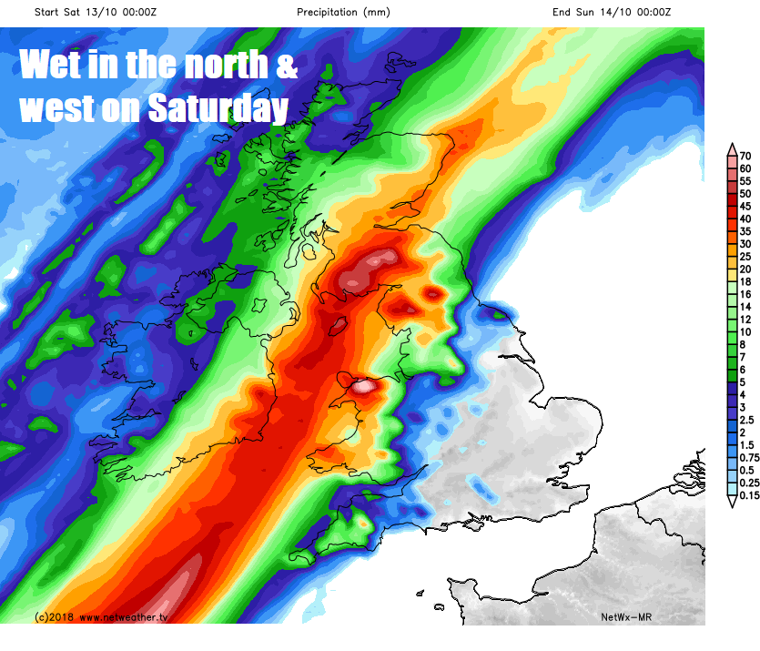
As well as the strong winds, a band of heavy and persistent rain along a frontal zone will become slow-moving across Wales, NW England and western Scotland tomorrow and into Saturday. 50-100mm of rain may fall by Saturday morning – bringing an increasing risk of flooding. The wind will increase to gale force across the southwest and Wales too, perhaps locally severe gales over western hills. Cloud and patchy rain will also affect Eastern Scotland, the Midlands and SW England, but the southeast of England and East Anglia should stay largely dry.
Saturday continuing wet and windy across northern and western areas along a slow-moving frontal zone, with a further 50-80mm over western hills, continuing the threat of flooding. Much of eastern and southeastern England stay mostly dry with bright or sunny spells – very warm here for the time of year – temperatures could reach 23-24C with any sunshine. Very mild elsewhere too, but everywhere windy, especially the west.
 Rain spreading to eastern areas Saturday night before clearing the east on Sunday morning, then a cooler day everywhere with sunny spells, England, Wales and eastern Scotland mostly dry, some showers across western Scotland and N. Ireland and perhaps Irish Sea coasts in the west.