


Cloud and rain in the south today, sunny spells in the north then a switch to rain in the north and sunshine in the south for Sunday. Risk of frost tonight.

After warm sunshine sent temperatures into the low twenties across the south yesterday, today will be in stark contrast across southern parts of England and Wales, as rain moves in accompanied by a strengthening northeasterly wind, making it feel noticeably colder. The weekend will see a flip in fortunes, with rain in the south today and sunny spells in the north – then on Sunday it switches round to rain in the north and sunny spells in the south. But for all it will be a chilly weekend, with clearing skies overnight leading to a widespread frost in rural areas. Into next week, it looks like staying generally dry, sunny and increasingly warm across much of England and Wales for much of the week, these conditions extending north to Scotland and Northern Ireland mid-week after some wet and windy weather to start the week.
For now, much of Scotland, N. Ireland and the far north of England start the day dry and bright but cold, with temperatures close to freezing across Scotland bringing a touch of frost. There are a few showers around across northern and western Scotland though and it’s a similar story for the rest of the day, with sunny spells and a few showers, mainly affecting the north and west.
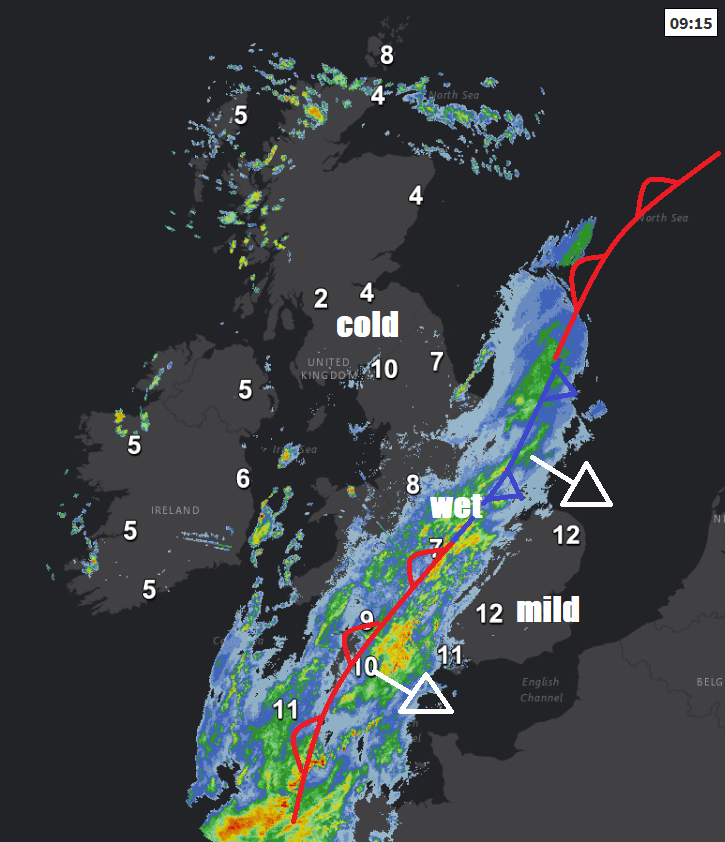
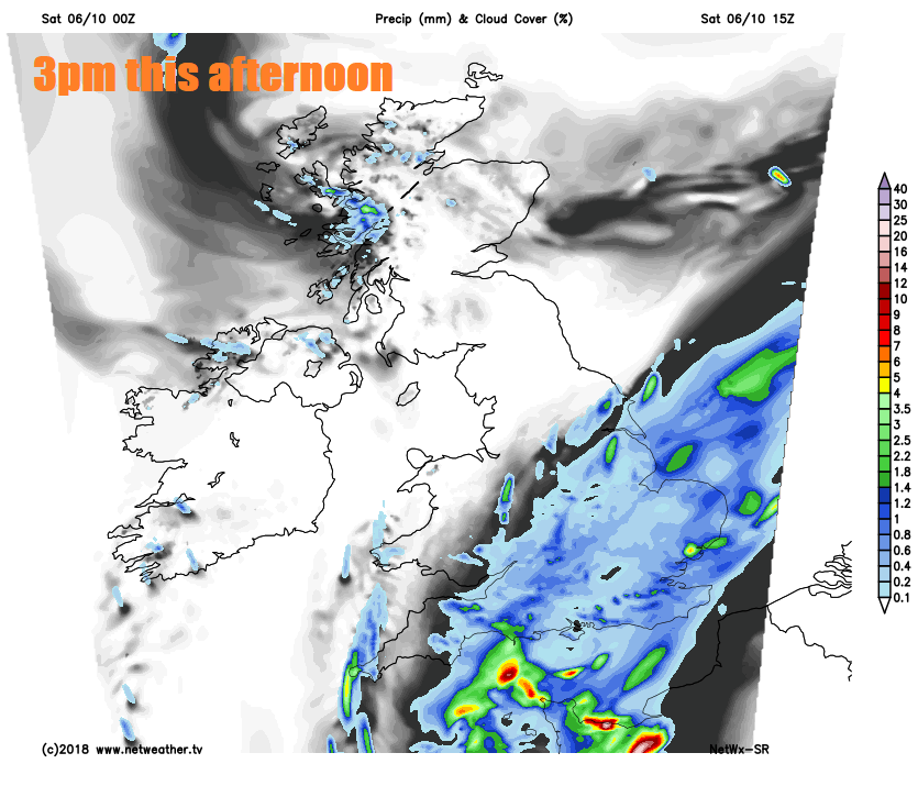
Further south, away from northern England a grey start with a broad band of rain along a cold front with locally heavy bursts stretching from SW England up through Wales, the Midlands and on up to East Yorkshire and Lincolnshire. SE England and East Anglia mostly dry to start but murky with low cloud, mist and fog patches. It should brighten up across all of northern England, Wales and SW England through the morning and into the afternoon, as the rain clears. But for the Midlands, East Anglia, central southern and southeast England it will stay dull with outbreaks of rain spreading southeast through the afternoon after the dry start in the southeast.
A chilly day everywhere, temperatures 10-12C at best this afternoon in the sunnier north and west, similar under the cloud and rain across the south and east, not helped by a strong northeasterly wind developing later towards eastern England. So we are likely to see a 10C drop in highs today, yesterday’s top temperature was 22.6C at Kew Gardens in west London.
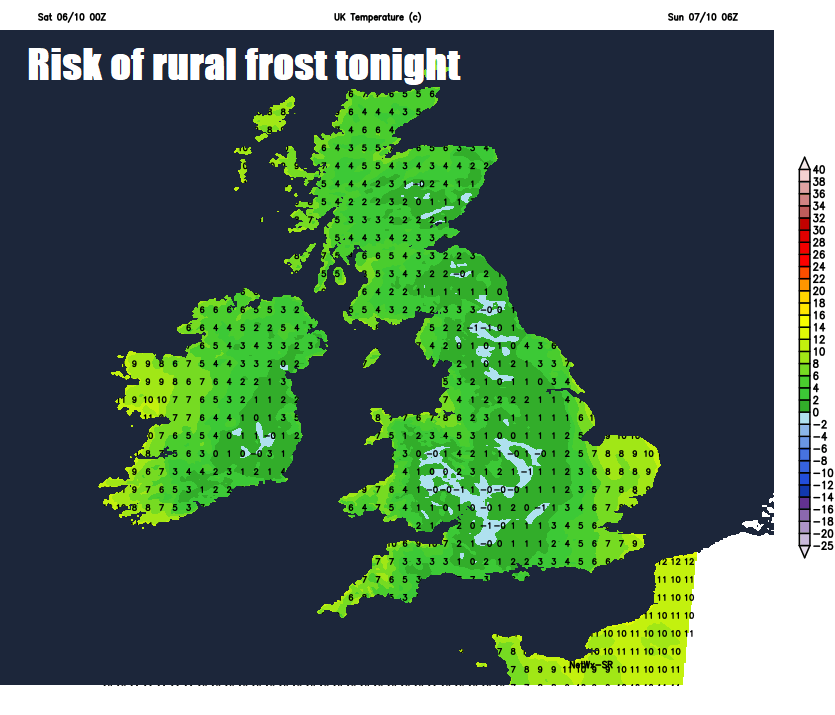
Today’s rain will linger into the evening across SE England and East Anglia, accompanied by a strong and cold northerly wind, which could touch gale force along North Sea coasts. The rain across SE England eventually clearing in the first part of the night to join most areas to a dry but cold night with clearing skies and light winds leading to temperatures falling to low single figures in towns and cities by dawn, frost developing in rural areas. The exception will be across be across northern and western Scotland, which will see cloud and rain with a strengthening wind arrive later in the night.
After a cold start, much more sunshine on offer across the whole of England and Wales tomorrow and staying mostly dry too, thanks to high pressure building across the south. While Scotland and Northern Ireland will see a cloudier day with outbreaks of rain, locally heavy, spreading east, accompanied by a strengthening southwesterly wind which will reach gale force, especially over western coasts and hills. Temperatures a little higher than today generally, ranging from 11-12C in the north to 13-14C in the south.
It will continue windy and cloudy with outbreaks of rain across much of Scotland, N. Ireland and far north of England on Monday, though the far north of Scotland may stay mostly dry. But for much of England and Wales it will be dry, bright and breezy with variable cloud and sunny spells, warmer too – with temperatures reaching 16-18C.
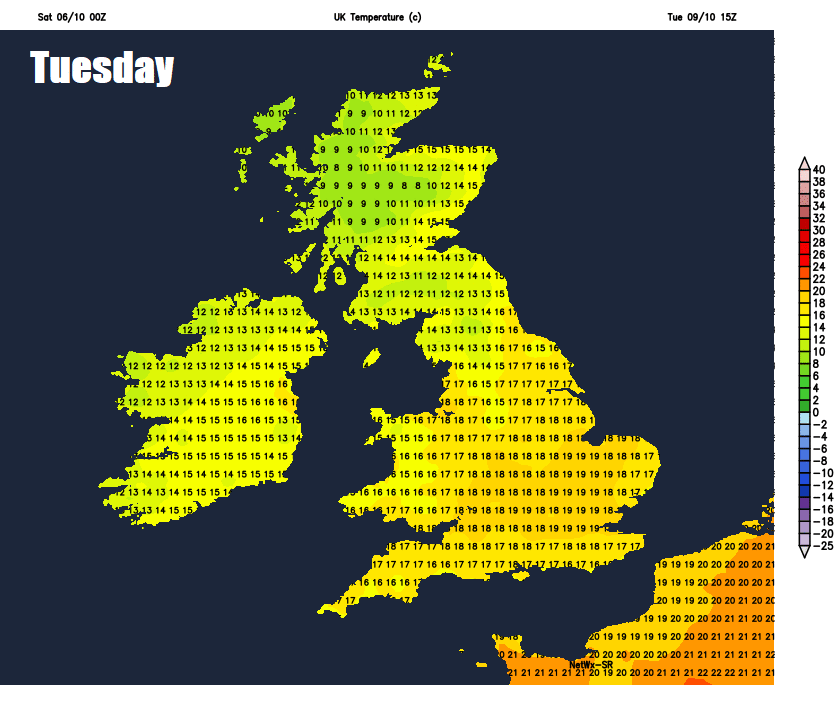
It will continue to warm up for the rest of the week across many areas, as low pressure sits out west to the west of Ireland and pulls in a deep southerly flow across the British Isles. Cloud, wind and rain will affect the far northwest on Tuesday, warm sunshine elsewhere which will spread across all parts on Wednesday, with temperatures perhaps reaching the low twenties centigrade in the south. Less certainty Thursday and Friday, with a threat of a spell or two of showery rain spreading northeast, though for many staying very mild for the time of year, warm again in the east on Thursday.


