Temperatures in the south will be in the low 20sC once more but cold air is arriving in the NW behind a band of rain. It will reach across the UK with a frost risk at the weekend.
It’s mild out there this morning, however, the nip in the air will be back by the end of the week. We are currently in a broad warm sector with a lot of cloud, grey skies and murk about. For southern Britain, there are light winds and early fog but the promise of warmth and sunny spells for the SE. Further north and west still damp conditions with SW wind as a cold front moves in bringing a heavier spell of rain and freshening winds even gales in the far north.
There are already some good breaks in the cloud, eastern Wales, over eastern Scotland, the moors of SW England are above the cloud, Kent and Suffolk have sunshine but mist and fog patches. Southern and eastern Britain continue with fined dry weather and the cloud will break up for the Midlands. Further northwest the low cloud and patchy rain persist until the winds pick up and the frontal rain begins to move in. The rain will be over NW half of Scotland and arriving along the north coast of Northern Ireland by this afternoon. The SW winds will freshen and then veer as the cooler air arrives.
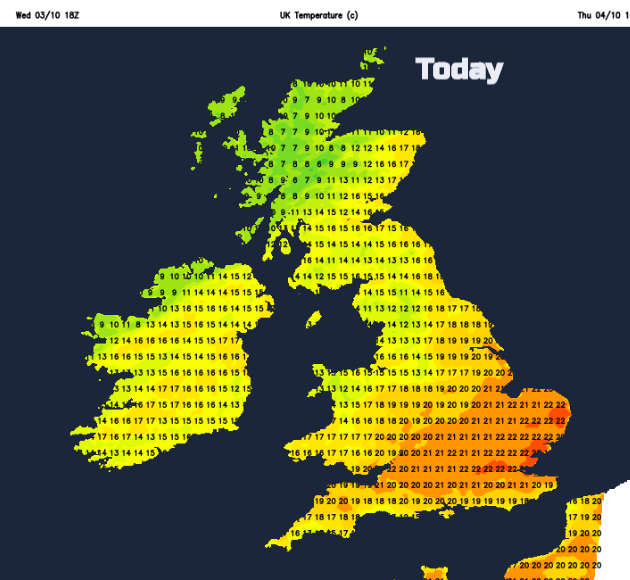
Behind the cold front, the temperatures will dip down to 10 or 11C for the late afternoon. Ahead of the front northern England and Northern Ireland will still manage 16 to 19C and for southern England 18 to 22C. A lovely day in the sunshine.
As the front nudges southwards, it will pep up the rain over NW England and NW Wales this evening as it moves over southern Scotland and more of Northern Ireland
It becomes windy in the far north of Scotland adding to the cold feel to the air. Temperatures behind the front will fall away well into single figures with a frost for more sheltered spots. Much of England and Wales stays calm and milder but with a wet start for counties near the Scotland England border for the start of Friday. There will be the risk of fog for southern parts of the UK too.
The low pressure centre swings near to Shetland on Friday drawing down colder air. Here it stays very windy with gales. There is a strong divide of mild air and colder air with still the low 20s C for southern England and East Anglia and then a real change for the rest of the UK. Fresher and colder. The frontal band keeps cloud and dampness across Wales, northern England and the north coast of Devon and Cornwall but elsewhere there will be sunny spells. We can’t forget the front just yet, but an occluding front moves into northern Scotland, bringing some wintry bits to the NW Highlands
By early Saturday everywhere will be in the north to NW wind and it will be colder for all as the weekend begins.

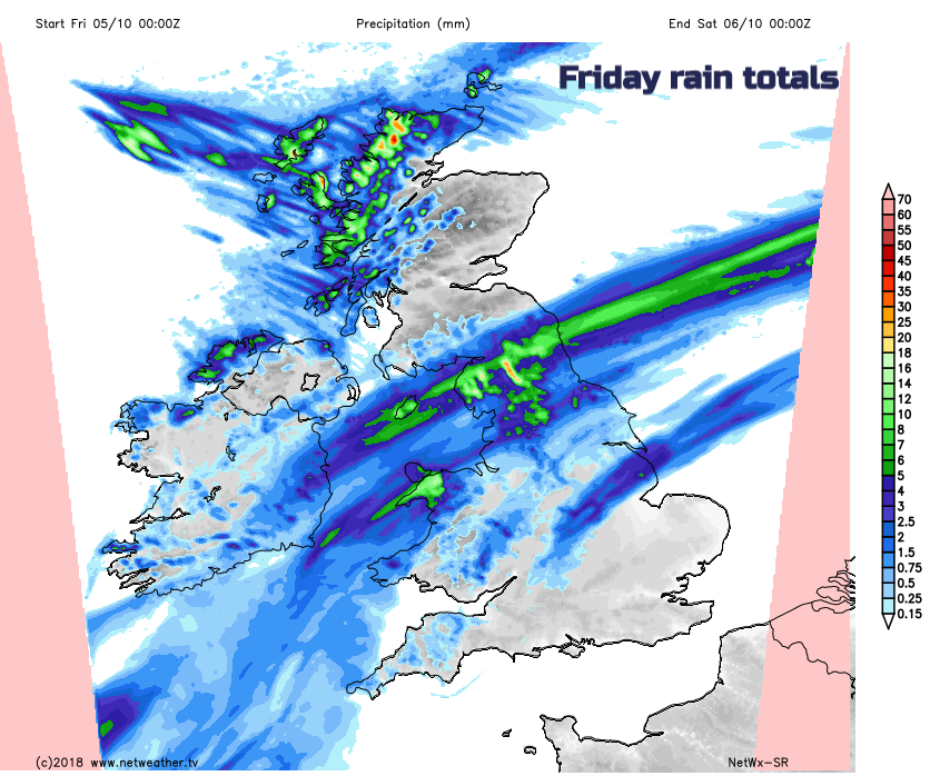
There had been concerns about how the lingering front might invigorate and bring heavy rain over England and Wales this weekend. It looks like it will stay as quite a flat feature, not deepening too much into a new low. Saturday will feel cold and the winds will pick up during the day so remember this for any weekend plans. There will be a spell of wet weather across England and Wales drifting towards SE England by Saturday evening.
Clearer, drier weather will already be spreading in from the west as pressure begins to build.
Sunday overall will be a fine day with sunshine and light winds after an early frost for the SE half of the UK. For the NW half, the winds will strengthen from the southwest and the cloud will increase through the day with rain for the Scottish Isles and NW Highlands.
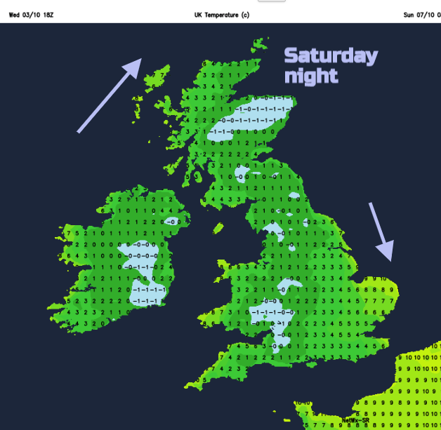
The weekend will be cold, chilly by night with a frost risk. Saturday brings rain for some and there will be long spells of fine, sunny weather too. Find your winter coat, this warmth will be fading.