
Storm Helene will arrive during Monday, bringing a spell of wet and windy weather to the UK and Ireland.
It's been blustery first thing across northern Britain today. But with the winds already easing down here, it's all eyes down to our southwest as Storm Helene (ex-hurricane Helene) edges toward the British Isles.
The storm, which by the time it reaches us will be a standard, but deep and intense low pressure area rather than a tropical storm or hurricane, will be with us from Monday and into Tuesday. Bringing with it a spell of wet, windy weather. It'll be western and northern regions which are likely to see the windiest weather, with gusts in excess of 70mph possible in exposed areas - plenty enough to cause some disruption.
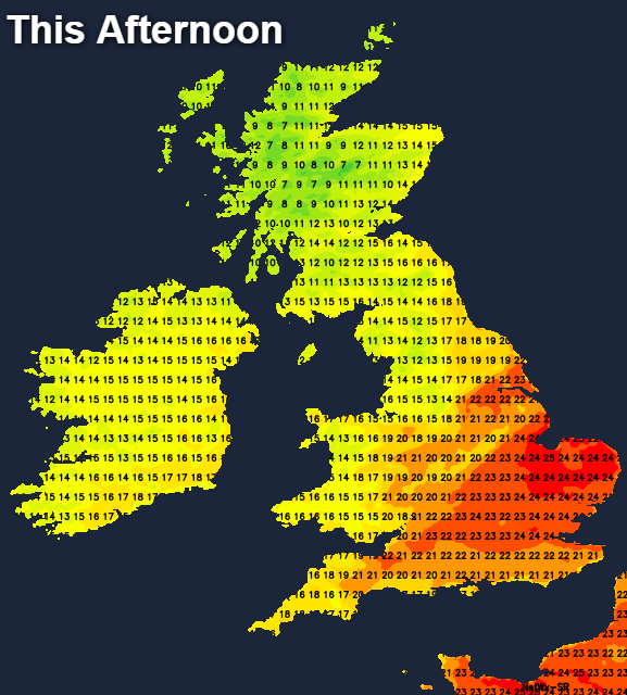
Today, with the strongest gusts having eased this morning in the north, all parts will see a similarly breezy day. There is some rain moving southeast, which is becoming increasingly patchy the further it gets. As has been so common of late, the southeast corner will keep out of trouble, and keep the warmest temperatures with highs heading up toward the mid-twenties. For other parts of England and Wales, 18-22c will be more like it, with Scotland and Northern Ireland a few degrees cooler. Behind the bits and pieces of rain moving southeast through England and Wales, there'll be some bright or sunny spells developing, but also some showers getting into western and especially northwestern Scotland.
This evening and overnight, most parts will be dry with just a few showers left over in the west. Northern Britain will be cool again with lows dipping into single-figures, but further south it's much milder with temperatures sticking in the teens.
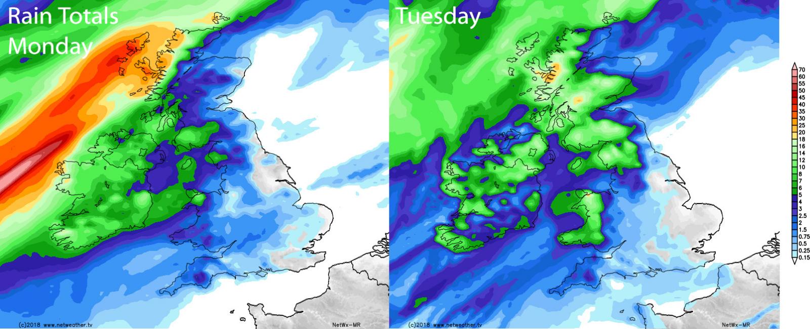
Monday sees the arrival of Storm Helene, but with different outcomes depending on where you are. For much of England and Wales, it's going to be a strangely warm if increasingly windy, but mostly dry day. Temperatures will perhaps get up to 25-26c in the southeast, with other parts into the low-twenties. The first band of rain will move up through Ireland fairly early on though, getting into northwest England and western Scotland later, with perhaps a few showers in other western parts. A persistent, heavy spell of rain will then set in across the north and west during the evening and overnight, before clearing east by Tuesday morning.
There'll also be the winds to watch. They'll peak first across the southwest of Ireland, then heading up through the Irish Channel, affecting western coasts of Britain. They'll then transfer across northern England, southern Scotland and north Wales into Monday evening and overnight, before easing away into the North Sea. There is still some uncertainty over the precise track of the low pressure centre though, so there may be some change to the areas with the strongest winds.
After a wet start, many parts dry out during Tuesday, although there'll be some blustery showers blowing into Western regions. It'll be another warm day across much of England, Wales and eastern Scotland with maxes again making it into the mid-twenties in the southeast.
Another low won't be far away at this stage though, organising the showers across Ireland initially, then pushing those into Western Britain later in the afternoon and evening. At the same time, winds really increase across the northwest, with gusts perhaps exceeding those from Storm Helene during the latter part of the day and overnight.
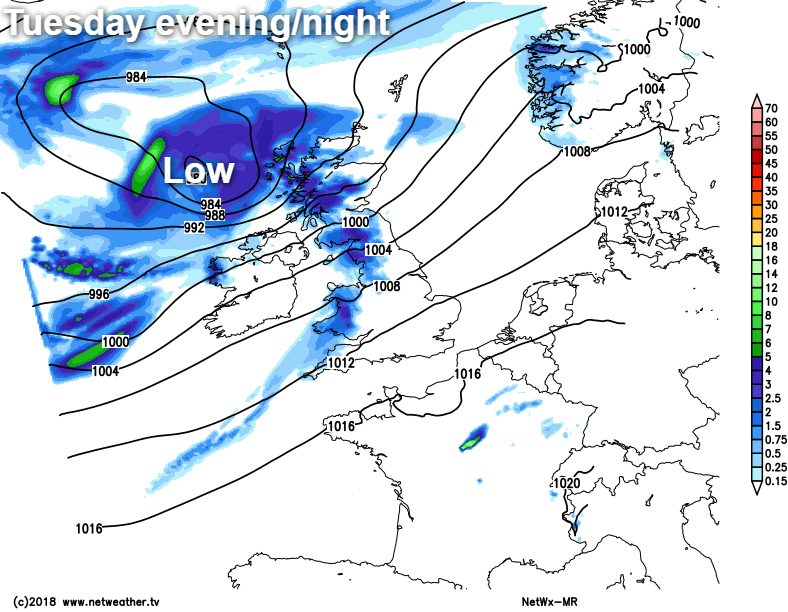
There is some uncertainty over developments of this one as well, but currently, it's the north and west of Ireland and Northern Ireland, then western and northern Scotland forecast to see the peak winds, which could exceed 80mph with exposure.
That should all clear out during the first half of Wednesday, to leave all parts similarly placed in blustery southwest winds. There'll be showers affecting the north and west in particular, with the best of the drier and sunnier weather further south and east. It'll still be warm in eastern and central parts too, with temperatures into the high-teens or low-twenties for many - cooler in the north and west though.
The rest of the week looks mixed, with another deep area of low pressure potentially set to arrive late on in the week, or into the weekend.


.jpg?w=1200)


