A bit of everything this weekend really, some rain, some sunshine and also some warm temperatures. Next week sees a north-south split taking hold.
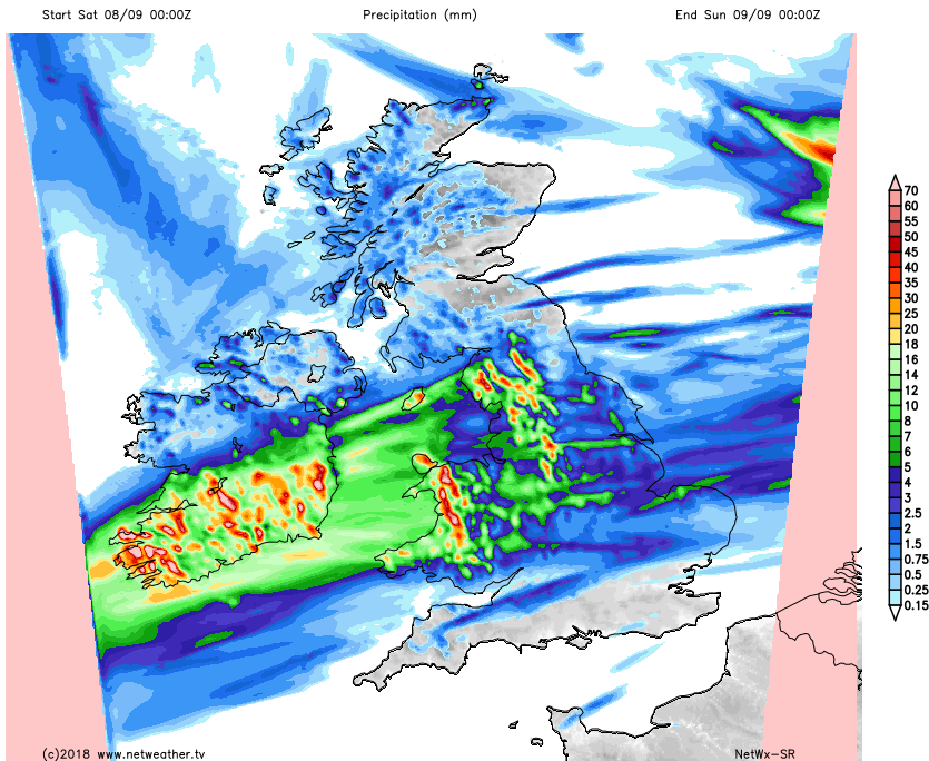
We have rain moving in from the west to get the weekend rolling this week, not all will see it, but a large central swathe of England, along with Wales will get a bit of a soaking. With the heaviest rain in the west.

The radar image above shows the area of rain, and also picks out the places best placed to miss the majority of it. That's the far south of England, particularly the southeast, and a good part of Scotland - although there will be some showers moving into western parts.
As the wet weather moves east, it will tend to break up, and become lighter, with showers following in on a similar path behind it, which will continue overnight. Rainfall totals of 10mm or so are possible in western regions, with high ground seeing upwards of 25-40mm.
Despite the rain, it will be a mild day just about everywhere, with highs widely into the high teens or low-twenties. There will be a fairly keen southwest wind blowing, especially across England and Wales which may knock the edge off of those values, particularly if you're under the rain as well.
This evening and overnight, showers will continue to affect western parts, running right up through England and Wales, perhaps into southern Scotland too. With a few making it further east. The cloud and outbreaks of rain will help keep temperatures up overnight here, with lows probably not dropping beneath the teens. Bucking that trend will be central and northern Scotland though, with clearer skies and fresher air still in place, making for a cooler low of 3-7c.
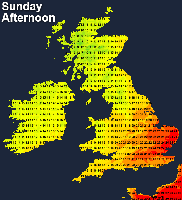
Into Sunday, and those western showers will continue initially, slowly easing down but some will make a move further southeast through the day. As one batch of showers back-away, another will arrive though, this time into the west of Scotland and perhaps the far northwest of England, becoming more widespread later. Between and away from any showers, some sunny spells should develop. Temperatures will be warmest eastern, southern and central parts, with the high-teens to low-twenties typical. With some sustained sunshine, the southeast corner could see highs rise further still, toward the mid-twenties, but equally the northwest will be cooler at 11-14c.
Into the start of next week, and we see what's likely to be a recurring theme, with low pressure not too far from the north of Scotland, and high pressure not too far from the south of England. In fact, Monday will see two lows nearby - the one which brought Sunday's showers will be moving away into the North Sea, with another following quite quickly behind to bring a spell of wet, windy weather from the west later.
The wet weather from that will eventually get into Wales and Northwest England, but elsewhere it's dry but not as warm as Sunday. The warmth will be back on Tuesday across a good part of central and Eastern England though.

Weather-wise, there will still be some showers in the west to start the day Tuesday, but in general, there'll be plenty of bright or sunny weather. The next low will be moving in off of the Atlantic during the day though, to bring another spell of rain or showers into the north and west.
The north-south split stays with us into midweek and beyond, with those in the south seeing the best of the dry, fine weather, whereas those further north will often catch the rain or showers, as systems move through. The south, and particularly the southeast will be warmest.