It's going to be a quiet, often fine and warm end to August and meteorological summer.
August seems to be going out on a quiet mostly dry, quite pleasant note ending a summer to remember in more ways than one. The heathland fires and the persistent heat from May into August part of a cycle of weather that seems to occur approximately every twenty-one years or so. Whether we see more of this into autumn is open to debate but looking at the latest computer models, it seems highly likely that the first half of September will be mostly fine and dry.
| Location | Overnight low |
|---|---|
| Cairngorm | 1.2c |
| Eskdalemuir | 1.5c |
| Sennybridge | 2.4c |
| Shap | 2.5c |
| Tulloch Bridge | 2.6c |
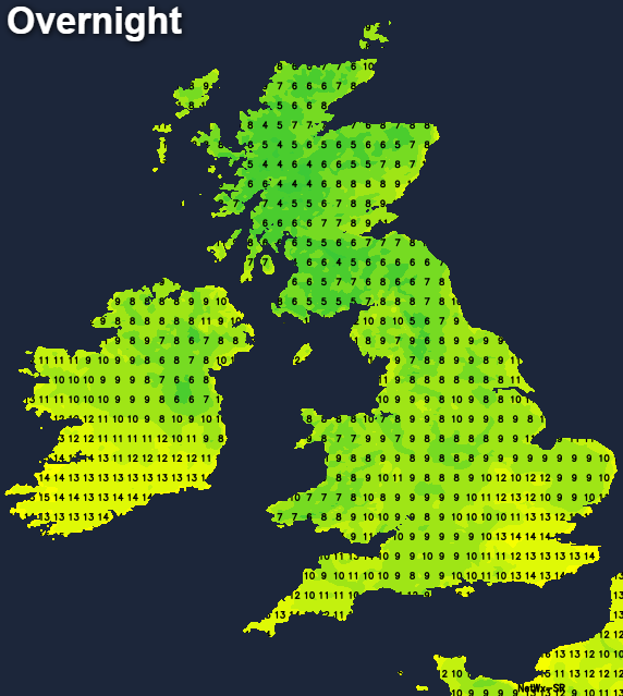
It's a chilly start this morning where skies have been clear overnight, with early mist patches in rural areas soon clearing. Cloud amounts will vary, but most parts will be fine with sunny spells as an anticyclone becomes established across most regions. The cloud could become thick enough to produce an isolated light shower almost anywhere, but you'll be very unlucky if you catch one with most places staying dry.
It'll become pleasantly warm where you have the best of the sunshine, with top temperatures mostly between 18 and 22C across much of England and Wales. Scotland and Northern Ireland will see a somewhat cooler 14 to 17C, with probably a South or South Easterly breeze developing across Northern Ireland through the afternoon.
The dry, quiet weather will continue into the evening and overnight with generally well-broken skies. Clear spells will allow it to turn chilly again especially in rural areas. With light winds, patchy mist and perhaps patchy fog could form towards dawn, but these'll be short-lived soon clearing after sunrise. The exception could be the Channel Islands, Isles of Scilly and perhaps Cornwall, where the cloud could produce the odd shower later in the night, with the Channel Islands most at risk. Lowest temperatures around 4 or 5C in some Scottish glens but 7 to 9C more generally in rural areas and 10 to 13C in towns and cities.
Friday will be similar in another mainly dry day, with probably more in the way of sunshine over much of England, Wales and central and eastern parts of Scotland. As a result and after a chilly start in some rural areas, temperatures should reach a warm 19 to 23C quite widely by the afternoon and perhaps 24C over parts of the East and South East in just gentle breezes. Northern Ireland, the far West of Scotland, West Wales particularly Dyfed and the South West will see more in the way of cloud. Here mostly light showers seem likely especially later in the day, in a light or moderate South or South Easterly breeze., with top temperatures in the West mainly in the range 17 to 20C.
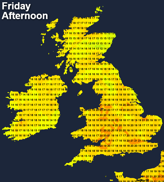
The evening and night see the cloud and patchy rain perhaps 'creeping' a little further eastwards, although its extent is uncertain at present. For particularly central and eastern parts of England and Scotland, however, it'll remain dry with generally well-broken skies in just a light South or South Easterly breeze. It'll turn misty again in some rural areas with perhaps a few short-lived fog patches forming towards dawn. It should also not turn quite so chilly, with minimum temperatures 7 to 9C in rural areas East of the Pennines and across East Scotland, but 10 to 13C more generally.
The coming weekend sees somewhat of an East/West split across the country. The East and many central areas should stay mostly dry with sunny spells leading to a warm afternoon. Further West and over Northern Ireland, you're likely to see more in the way of cloud and a few showers, although the boundary between two remains something of a debate at the moment.