The changeable spell shows no signs of ending just yet with more rain and showers moving through at times. The north and west of the country will often bear the brunt as the southeast stays warmest and driest.
We have a three-way split in our weather today as a cold front slowly edges southeast marking the divide between fresher, cooler air and the still humid and very warm air still affecting the southeast.
To the north of the front, across Scotland and the far north of England, there'll be a fair bit of cloud, with the best of the breaks in the east. There'll also be some bits and pieces of showery rain, which'll become more meaningful and widespread later in the day. The same can be said about the rain on the weather front, to start the day it's very patchy, but it'll perk up this afternoon and evening as it moves through Northern England, into Wales and the Midlands.
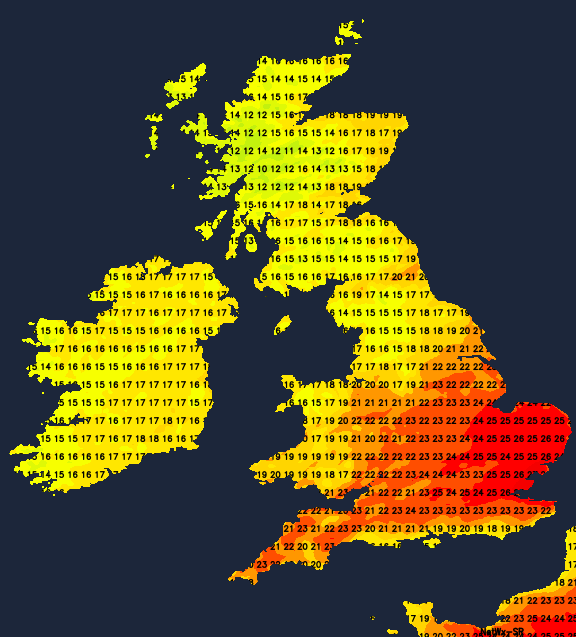
To the southeast of that, another mostly dry, warm, humid day with some good spells of sunshine breaking through. Temperatures in the southeast corner will peak at 24-27c, other parts of central and southern England at 21-24c. Elsewhere, 18-22c will be more like it, along with a fresher feel.
Overnight and into Thursday the front carries on moving southeast, and it'll take well into the afternoon or even early evening before clearing the southeast corner. There'll not be too much rain left on it by this stage, but it'll certainly be a different type of day tomorrow with the extra cloud and patchy wet weather moving through. Elsewhere tomorrow, it's a day of sunny spells and a fairly good number of showers. They'll be most frequent in the north and west, but a good number will make their way across the country, blown on by a fresh west to southwest wind. Some will be on the heavy side and don't be surprised if you hear a few rumbles of thunder too.
Temperatures tomorrow will range from 18-21c in the southeast, 16-19c just about everywhere else.
Friday sees low pressure not too far away - moving through to the south of Iceland. It's going to bring more weather fronts in toward the British Isles, and that means more rain for some at least.
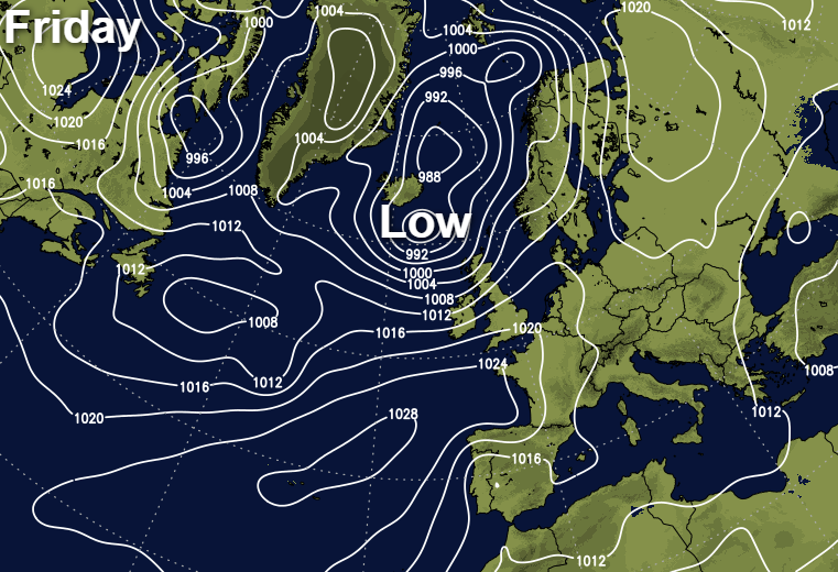
As has so often been the case of late, it'll be the northwestern half of Britain bearing the brunt of that, as the more sheltered southeast stays driest and warmest. It'll be blustery in the north and west as well, with gales possible in northern Scotland as the low moves past overnight and during the first part of Saturday.
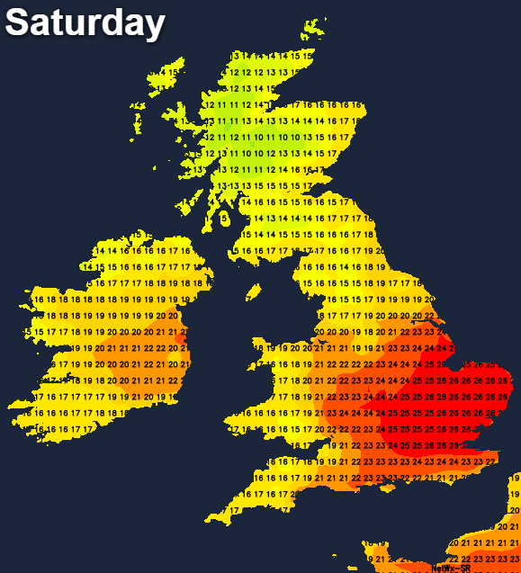
The weekend then starts with some showers mainly affecting western regions, further east, and especially southeast it'll be drier, with some sunny spells breaking through. For the southern part of England, temperatures will be on the up again by this point too, nudging into the mid-twenties. Elsewhere, it's cooler with the high-teens or perhaps low-twenties likely.
Into Sunday, the next Atlantic weather system will be arriving with us. There's a little uncertainty over the track and timing of this one, but it's most likely that northern and western parts will again catch the brunt of the wet, windy weather with the southeast staying driest.