


A wet Sunday on the way for much of the UK. Showers will follow on Monday, especially in the east. Then warming up and drying out in the south and east, those further north and west stay wetter and cooler.
One quick glance at the radar tells you most of what you need to know about the weather today, and it's wet. The reason is that we have low pressure on the scene with multiple weather fronts over the British Isles, meaning very few people are going to get away with a dry day.
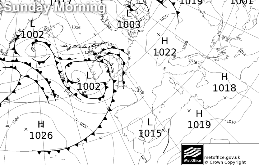
We have two main areas of rain on the go. One over the northern half of the country, moving southwest to northeast, another further south heading west to east. .Both have some heavy bursts on them, and once they clear through, there'll be some sharp, thundery showers following on behind. The rainfall totals over the next 24 hours will be starting to mount up, with 25-50mm plus in some spots. So plenty wet enough to cause some problems with surface water and flash flooding.
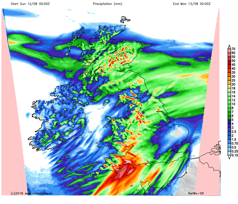
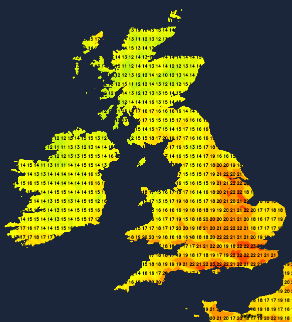
Despite the rain, it's actually going to be warm, humid day with highs peaking in the east of England at 22-25c, elsewhere, 17-21c will be more like it. The rain will take it's time to clear from the north of Scotland., along with parts of southern and eastern England overnight. There'll also be further showers - particularly in the east. Temperatures won't fall far either, with most parts staying in the mid-teens.
Monday will see the showers continue to develop, especially in the east of the country. They're going to be heavy and thundery at times, but away from them, there will be some bright or sunny spells. It'll be another warm day with a humid feel, with maxes reaching similar levels to today.
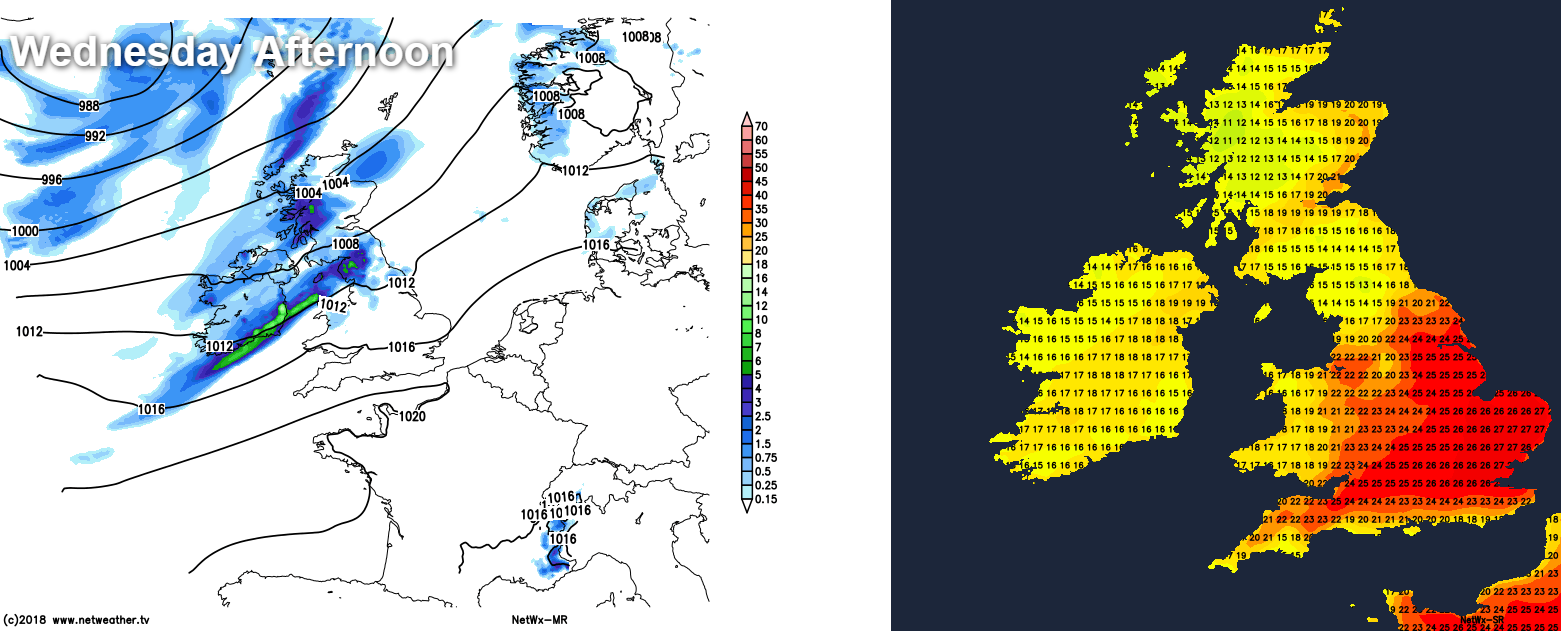
Tuesday and Wednesday will see a familiar pattern setting up, as high pressure nudges up close to the south of the UK. That'll mean plenty of dry, fine and very warm weather in the south, but further north, and especially in the northwest it'll be cooler and wet at times with low pressure never too far away.
By Wednesday afternoon, temperatures are likely to make it up into the mid-high twenties in parts of southern, central and eastern England. At the same time though, rain will be working down from the northwest, with cooler air behind it.
The rain will continue to journey southeast during Thursday, fading the further southeast it gets, but introducing fresher, cooler conditions to all parts as it moves through.
As we end with the week and move into the start of the weekend, we're back to a similar scenario to midweek. With high pressure doing its best to ridge up into the south, but low pressure further northwest pushing against it. That'll mean that the driest, warmest weather will be in south and southeast, but even here some patchy, showery rain may move through at times. The wettest, cooler weather will be further northwest though.
Beyond that, well there are signs that high pressure will continue to try to push further north into the British Isles, although it doesn't look like a straightforward process. So it may well be that initially at least, that northwest-southeast split will continue to be a feature, but the into the final quarter of the month, it does look possible that the high will be able to establish itself further north too.


